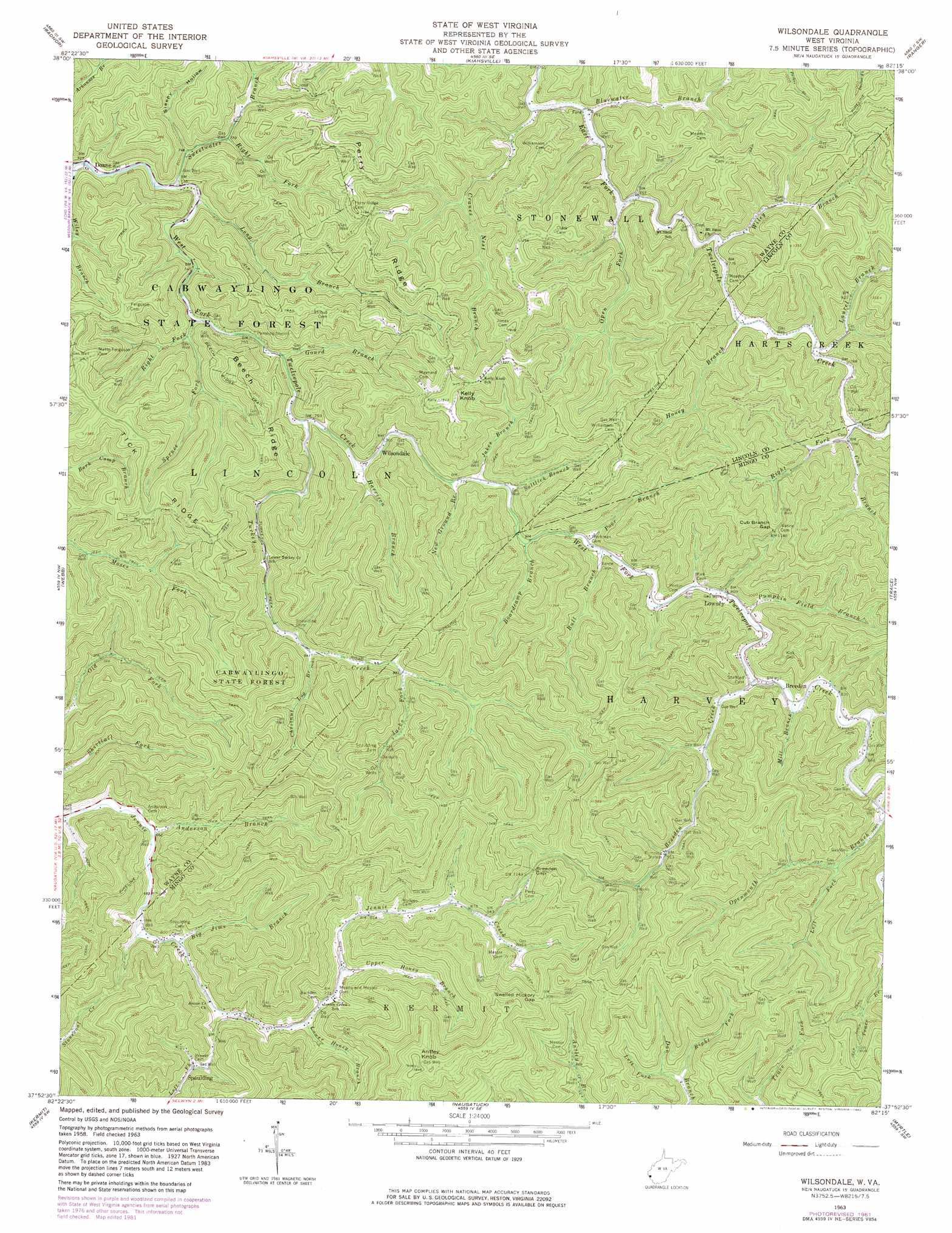
Wilsondale Topo Map West Virginia
To zoom in, hover over the map of Wilsondale
USGS Topo Quad 37082h3 - 1:24,000 scale
| Topo Map Name: | Wilsondale |
| USGS Topo Quad ID: | 37082h3 |
| Print Size: | ca. 21 1/4" wide x 27" high |
| Southeast Coordinates: | 37.875° N latitude / 82.25° W longitude |
| Map Center Coordinates: | 37.9375° N latitude / 82.3125° W longitude |
| U.S. State: | WV |
| Filename: | o37082h3.jpg |
| Download Map JPG Image: | Wilsondale topo map 1:24,000 scale |
| Map Type: | Topographic |
| Topo Series: | 7.5´ |
| Map Scale: | 1:24,000 |
| Source of Map Images: | United States Geological Survey (USGS) |
| Alternate Map Versions: |
Wilsondale WV 1963, updated 1964 Download PDF Buy paper map Wilsondale WV 1963, updated 1977 Download PDF Buy paper map Wilsondale WV 1963, updated 1982 Download PDF Buy paper map Wilsondale WV 1996, updated 2003 Download PDF Buy paper map Wilsondale WV 2010 Download PDF Buy paper map Wilsondale WV 2014 Download PDF Buy paper map Wilsondale WV 2016 Download PDF Buy paper map |
1:24,000 Topo Quads surrounding Wilsondale
Prichard |
Wayne |
Nestlow |
Branchland |
Hager |
Louisa |
Radnor |
Kiahsville |
Ranger |
Big Creek |
Milo |
Webb |
Wilsondale |
Trace |
Chapmanville |
Inez |
Kermit |
Naugatuck |
Myrtle |
Holden |
Thomas |
Varney |
Williamson |
Delbarton |
Barnabus |
> Back to 37082e1 at 1:100,000 scale
> Back to 37082a1 at 1:250,000 scale
> Back to U.S. Topo Maps home
Wilsondale topo map: Gazetteer
Wilsondale: Forests
Cabwaylingo State Forest elevation 289m 948′Wilsondale: Gaps
Breeden Gap elevation 358m 1174′Cub Branch Gap elevation 361m 1184′
Swelled Hickory Gap elevation 400m 1312′
Wilsondale: Populated Places
Breeden elevation 253m 830′Doane elevation 218m 715′
Lowney elevation 240m 787′
Spaulding elevation 241m 790′
Wilsondale elevation 233m 764′
Wilsondale: Post Offices
Breeden Post Office elevation 253m 830′Wilsondale Post Office elevation 232m 761′
Wilsondale: Ridges
Beech Ridge elevation 392m 1286′Perry Ridge elevation 400m 1312′
Wilsondale: Streams
Anderson Branch elevation 199m 652′Big Jims Branch elevation 211m 692′
Bluewater Branch elevation 226m 741′
Boardcamp Branch elevation 238m 780′
Breeden Creek elevation 245m 803′
Bull Branch elevation 238m 780′
Chestnut Log Branch elevation 255m 836′
Cranes Branch elevation 226m 741′
Cub Branch elevation 238m 780′
Gourd Branch elevation 231m 757′
Harrison Branch elevation 230m 754′
Hickory Branch elevation 240m 787′
Honey Branch elevation 233m 764′
Jacks Fork elevation 278m 912′
Jakes Branch elevation 233m 764′
Laurel Branch elevation 235m 770′
Left Fork Dan Branch elevation 282m 925′
Left Fork Openmouth Branch elevation 272m 892′
Long Branch elevation 218m 715′
Lower Honey Branch elevation 232m 761′
Mill Branch elevation 247m 810′
New Ground Branch elevation 233m 764′
Open Fork elevation 228m 748′
Poor Branch elevation 238m 780′
Pumpkin Field Branch elevation 243m 797′
Right Fork Cub Branch elevation 241m 790′
Right Fork Dan Branch elevation 255m 836′
Right Fork Spruce Fork elevation 227m 744′
Right Fork Sweetwater Branch elevation 232m 761′
Saltlick Branch elevation 234m 767′
Spruce Fork elevation 224m 734′
Sweetwater Branch elevation 220m 721′
Turkey Creek elevation 228m 748′
Upper Honey Branch elevation 235m 770′
Wiley Branch elevation 230m 754′
Wiley Branch elevation 223m 731′
Wilsondale: Summits
Antley Knob elevation 561m 1840′Kelly Knob elevation 461m 1512′
Wilsondale: Trails
Beech Ridge Trail elevation 379m 1243′Wilsondale: Valleys
Sleepy Hollow elevation 227m 744′Wilsondale digital topo map on disk
Buy this Wilsondale topo map showing relief, roads, GPS coordinates and other geographical features, as a high-resolution digital map file on DVD:
Western Virginia & Southern West Virginia
Buy digital topo maps: Western Virginia & Southern West Virginia