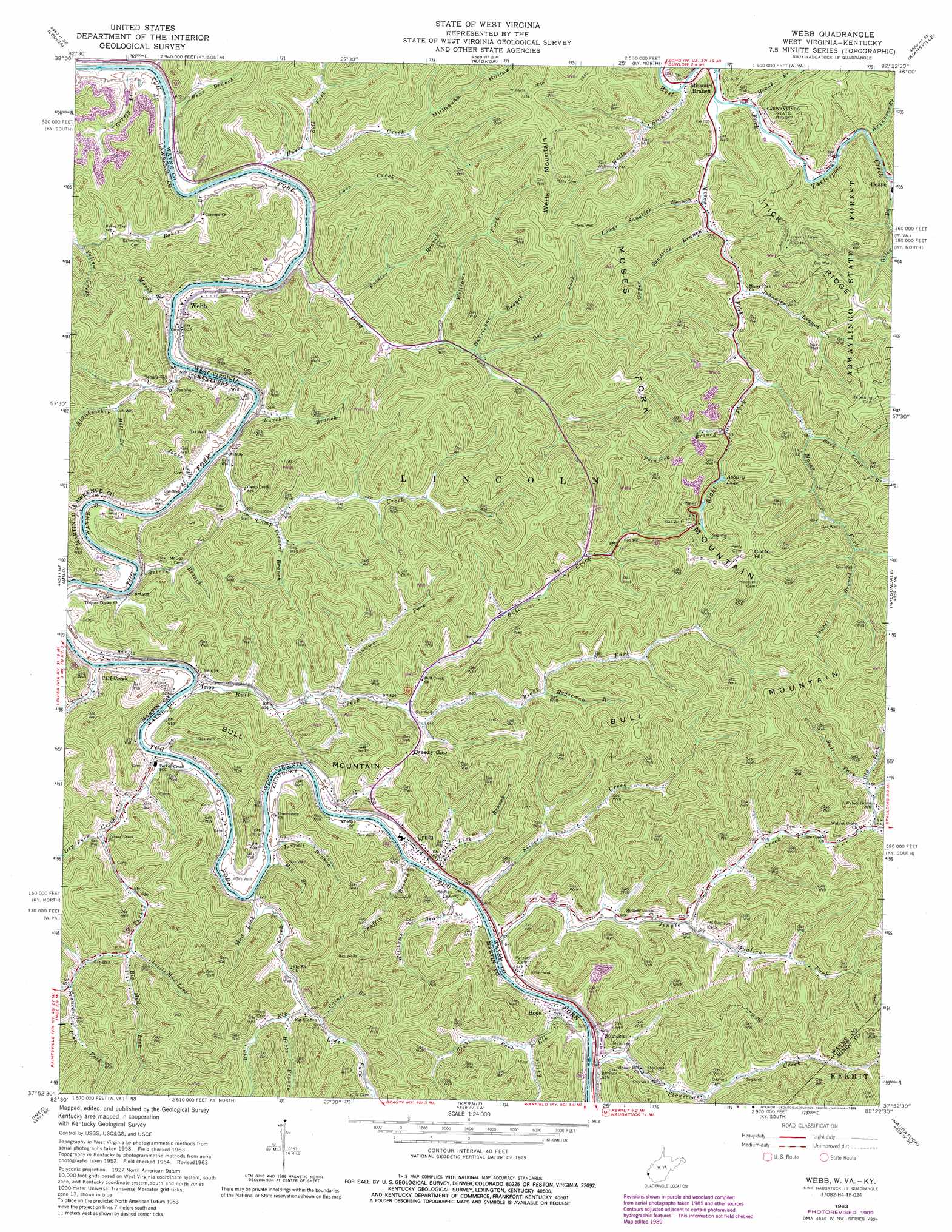
Webb Topo Map West Virginia
To zoom in, hover over the map of Webb
USGS Topo Quad 37082h4 - 1:24,000 scale
| Topo Map Name: | Webb |
| USGS Topo Quad ID: | 37082h4 |
| Print Size: | ca. 21 1/4" wide x 27" high |
| Southeast Coordinates: | 37.875° N latitude / 82.375° W longitude |
| Map Center Coordinates: | 37.9375° N latitude / 82.4375° W longitude |
| U.S. States: | WV, KY |
| Filename: | o37082h4.jpg |
| Download Map JPG Image: | Webb topo map 1:24,000 scale |
| Map Type: | Topographic |
| Topo Series: | 7.5´ |
| Map Scale: | 1:24,000 |
| Source of Map Images: | United States Geological Survey (USGS) |
| Alternate Map Versions: |
Webb WV 1954, updated 1955 Download PDF Buy paper map Webb WV 1963, updated 1964 Download PDF Buy paper map Webb WV 1963, updated 1967 Download PDF Buy paper map Webb WV 1963, updated 1976 Download PDF Buy paper map Webb WV 1963, updated 1989 Download PDF Buy paper map Webb WV 2010 Download PDF Buy paper map Webb WV 2014 Download PDF Buy paper map Webb WV 2016 Download PDF Buy paper map |
1:24,000 Topo Quads surrounding Webb
Fallsburg |
Prichard |
Wayne |
Nestlow |
Branchland |
Adams |
Louisa |
Radnor |
Kiahsville |
Ranger |
Richardson |
Milo |
Webb |
Wilsondale |
Trace |
Offutt |
Inez |
Kermit |
Naugatuck |
Myrtle |
Lancer |
Thomas |
Varney |
Williamson |
Delbarton |
> Back to 37082e1 at 1:100,000 scale
> Back to 37082a1 at 1:250,000 scale
> Back to U.S. Topo Maps home
Webb topo map: Gazetteer
Webb: Gaps
Breezy Gap elevation 238m 780′Webb: Populated Places
Crum elevation 188m 616′Hode elevation 192m 629′
Millet (historical) elevation 178m 583′
Missouri Branch elevation 215m 705′
Stonecoal elevation 192m 629′
Tripp elevation 185m 606′
Upper Tug elevation 178m 583′
Webb elevation 187m 613′
Webb: Post Offices
Cassie Post Office (historical) elevation 181m 593′Webb: Reservoirs
Asbury Lake elevation 259m 849′Webb: Ridges
Tick Ridge elevation 409m 1341′Webb: Streams
Arkansas Branch elevation 218m 715′Bark Camp Branch elevation 234m 767′
Bear Branch elevation 168m 551′
Big Branch elevation 172m 564′
Big Elk Creek elevation 178m 583′
Big Mud Lick elevation 191m 626′
Blankenship Branch elevation 168m 551′
Bull Creek elevation 171m 561′
Bull Fork elevation 199m 652′
Burchett Branch elevation 168m 551′
Cainer Branch elevation 190m 623′
Calf Creek elevation 171m 561′
Camp Creek elevation 168m 551′
Chaffin Branch elevation 172m 564′
Coon Creek elevation 168m 551′
Dog Fork elevation 186m 610′
Drag Creek elevation 168m 551′
Dry Fork elevation 180m 590′
Griffy Branch elevation 169m 554′
Hagerman Branch elevation 201m 659′
Hobbs Branch elevation 182m 597′
Horse Creek elevation 170m 557′
Hurricane Branch elevation 185m 606′
Jarrell Branch elevation 179m 587′
Jennie Creek elevation 173m 567′
Jones Branch elevation 174m 570′
Jonnies Branch elevation 220m 721′
Laurel Branch elevation 250m 820′
Left Fork Big Elk Creek elevation 181m 593′
Lick Branch elevation 172m 564′
Little Elk Creek elevation 175m 574′
Little Mud Lick elevation 190m 623′
Lower Sandlick Branch elevation 216m 708′
Meade Branch elevation 215m 705′
Mill Branch elevation 189m 620′
Missouri Branch elevation 211m 692′
Moses Fork elevation 212m 695′
Mossy Branch elevation 178m 583′
Mud Lick elevation 172m 564′
Mudlick Fork elevation 183m 600′
Old Fork elevation 192m 629′
Painter Branch elevation 175m 574′
Peters Branch elevation 169m 554′
Right Fork Bull Creek elevation 196m 643′
Right Fork Little Elk Creek elevation 202m 662′
Right Fork Moses Fork elevation 225m 738′
Right Fork Stonecoal Creek elevation 193m 633′
Roberts Branch elevation 196m 643′
Rocklick Branch elevation 241m 790′
Shirttail Fork elevation 197m 646′
Silk Fork elevation 173m 567′
Silver Creek elevation 174m 570′
Spruce Pine Fork elevation 200m 656′
Stonecoal Creek elevation 185m 606′
Summer Fork elevation 181m 593′
Turkey Creek elevation 172m 564′
Upper Sandlick Branch elevation 216m 708′
Vincent Branch elevation 181m 593′
Wells Branch elevation 211m 692′
Williams Branch elevation 172m 564′
Williams Fork elevation 188m 616′
Webb: Summits
Bull Mountain elevation 426m 1397′Cotton Hill elevation 424m 1391′
Moses Fork Mountain elevation 394m 1292′
Wells Mountain elevation 388m 1272′
Webb: Valleys
Millhouse Hollow elevation 192m 629′Webb digital topo map on disk
Buy this Webb topo map showing relief, roads, GPS coordinates and other geographical features, as a high-resolution digital map file on DVD:
Western Virginia & Southern West Virginia
Buy digital topo maps: Western Virginia & Southern West Virginia