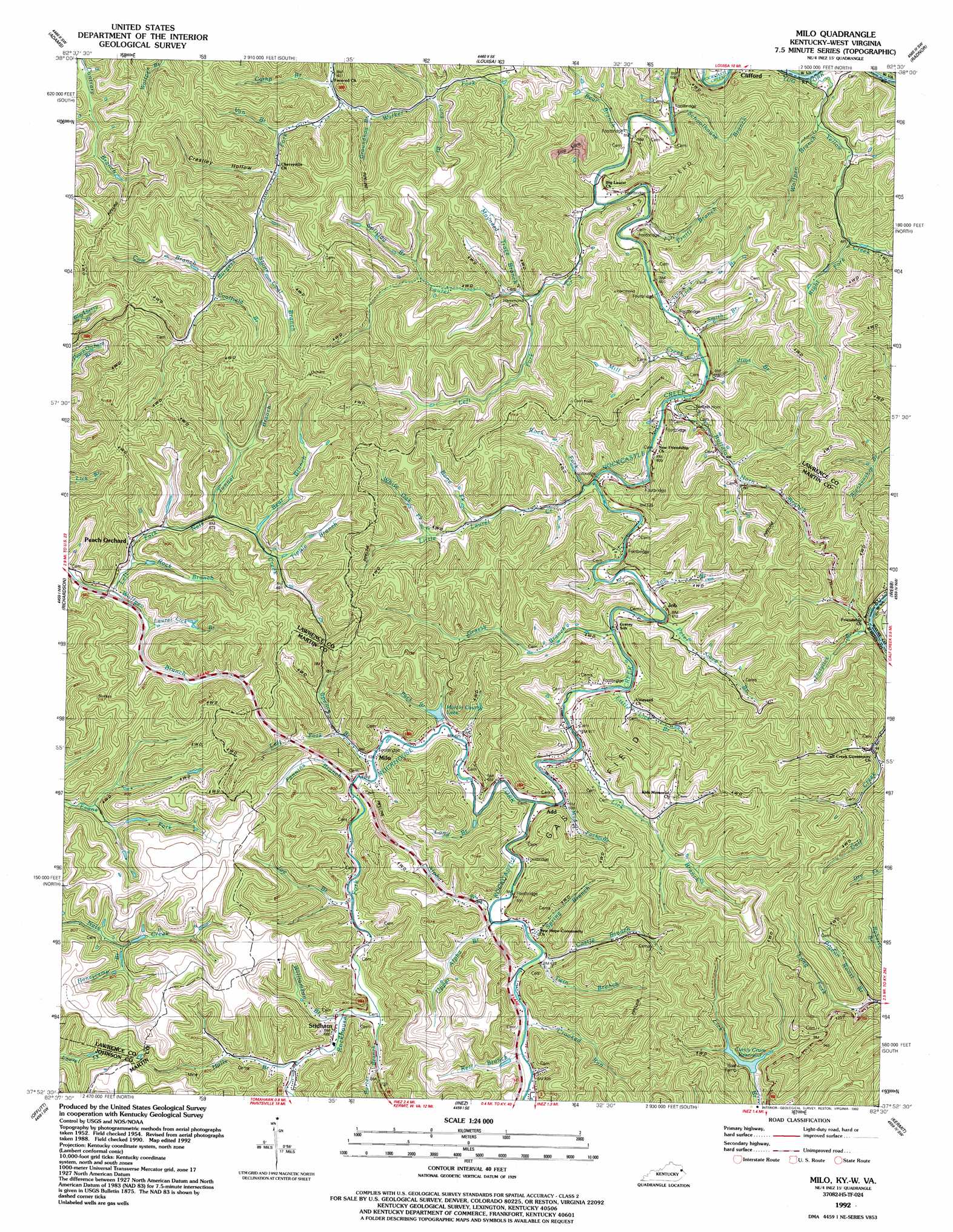
Milo Topo Map Kentucky
To zoom in, hover over the map of Milo
USGS Topo Quad 37082h5 - 1:24,000 scale
| Topo Map Name: | Milo |
| USGS Topo Quad ID: | 37082h5 |
| Print Size: | ca. 21 1/4" wide x 27" high |
| Southeast Coordinates: | 37.875° N latitude / 82.5° W longitude |
| Map Center Coordinates: | 37.9375° N latitude / 82.5625° W longitude |
| U.S. States: | KY, WV |
| Filename: | o37082h5.jpg |
| Download Map JPG Image: | Milo topo map 1:24,000 scale |
| Map Type: | Topographic |
| Topo Series: | 7.5´ |
| Map Scale: | 1:24,000 |
| Source of Map Images: | United States Geological Survey (USGS) |
| Alternate Map Versions: |
Milo KY 1954, updated 1955 Download PDF Buy paper map Milo KY 1954, updated 1967 Download PDF Buy paper map Milo KY 1954, updated 1978 Download PDF Buy paper map Milo KY 1954, updated 1989 Download PDF Buy paper map Milo KY 1992, updated 1992 Download PDF Buy paper map Milo KY 2010 Download PDF Buy paper map Milo KY 2013 Download PDF Buy paper map Milo KY 2016 Download PDF Buy paper map |
1:24,000 Topo Quads surrounding Milo
Webbville |
Fallsburg |
Prichard |
Wayne |
Nestlow |
Blaine |
Adams |
Louisa |
Radnor |
Kiahsville |
Sitka |
Richardson |
Milo |
Webb |
Wilsondale |
Paintsville |
Offutt |
Inez |
Kermit |
Naugatuck |
Prestonsburg |
Lancer |
Thomas |
Varney |
Williamson |
> Back to 37082e1 at 1:100,000 scale
> Back to 37082a1 at 1:250,000 scale
> Back to U.S. Topo Maps home
Milo topo map: Gazetteer
Milo: Gaps
Hall Gap elevation 286m 938′Milo: Populated Places
Castle elevation 197m 646′Job elevation 237m 777′
Laurel elevation 178m 583′
Milo elevation 195m 639′
Peach Orchard elevation 184m 603′
Stidham elevation 220m 721′
Milo: Post Offices
Mirty Post Office (historical) elevation 186m 610′Peach Orchard Post Office (historical) elevation 183m 600′
Stidham Post Office elevation 197m 646′
Milo: Reservoirs
Curtis Crum Reservoir elevation 210m 688′Martin County Lake elevation 198m 649′
Milo: Streams
Alpha Branch elevation 187m 613′Bear Branch elevation 179m 587′
Bear Branch elevation 210m 688′
Bone Fork elevation 216m 708′
Buffalo Horn Branch elevation 183m 600′
Camp Branch elevation 193m 633′
Castle School elevation 192m 629′
Coolfield Branch elevation 219m 718′
Cow Branch elevation 209m 685′
Crooked Run elevation 189m 620′
Fannins Branch elevation 191m 626′
Flutylick Branch elevation 176m 577′
Grassy Branch elevation 183m 600′
Groundhog Branch elevation 190m 623′
Halls Branch elevation 204m 669′
Honeycamp Branch elevation 216m 708′
Jims Branch elevation 183m 600′
Joe Branch elevation 194m 636′
Joe Branch elevation 183m 600′
Kell Branch elevation 187m 613′
Laurel Creek elevation 184m 603′
Laurel Lick Branch elevation 190m 623′
Left Fork Laurel Creek elevation 212m 695′
Left Fork Spence Branch elevation 190m 623′
Lick Branch elevation 177m 580′
Lick Branch elevation 198m 649′
Lick Branch elevation 195m 639′
Little Lick Branch elevation 183m 600′
Long Branch elevation 215m 705′
Long Branch elevation 200m 656′
Long Fork elevation 211m 692′
Maynard Trace Branch elevation 194m 636′
Mill Creek elevation 176m 577′
Mud Fork Branch elevation 193m 633′
Pack Branch elevation 193m 633′
Peter Cave Branch elevation 183m 600′
Pigeon Roost Branch elevation 204m 669′
Porter Branch elevation 198m 649′
Pruitt Branch elevation 187m 613′
Right Fork Yellow Creek elevation 188m 616′
Rock Branch elevation 183m 600′
Rock Fork elevation 181m 593′
Rockhouse Fork elevation 183m 600′
Schoolhouse Branch elevation 208m 682′
Smith Branch elevation 191m 626′
Spence Branch elevation 189m 620′
Splitlog Branch elevation 217m 711′
Spring Branch elevation 188m 616′
Stone Cool Branch elevation 228m 748′
Tipple Branch elevation 207m 679′
Tunnel Branch elevation 196m 643′
Twin Branch elevation 188m 616′
Upper Alpha Branch elevation 191m 626′
Van Branch elevation 189m 620′
Walker Fork elevation 209m 685′
White Oak Fork elevation 215m 705′
Williamson Branch elevation 200m 656′
Wolfpen Branch elevation 180m 590′
Wolfpen Branch elevation 173m 567′
Yellow Creek elevation 170m 557′
Milo: Summits
Peach Orchard Knob elevation 316m 1036′Milo: Valleys
Crestley Hollow elevation 191m 626′Milo digital topo map on disk
Buy this Milo topo map showing relief, roads, GPS coordinates and other geographical features, as a high-resolution digital map file on DVD:
Western Virginia & Southern West Virginia
Buy digital topo maps: Western Virginia & Southern West Virginia