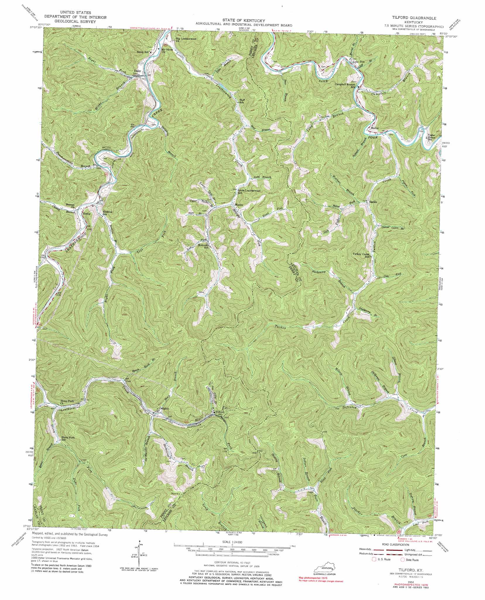
Tilford Topo Map Kentucky
To zoom in, hover over the map of Tilford
USGS Topo Quad 37083a1 - 1:24,000 scale
| Topo Map Name: | Tilford |
| USGS Topo Quad ID: | 37083a1 |
| Print Size: | ca. 21 1/4" wide x 27" high |
| Southeast Coordinates: | 37° N latitude / 83° W longitude |
| Map Center Coordinates: | 37.0625° N latitude / 83.0625° W longitude |
| U.S. State: | KY |
| Filename: | o37083a1.jpg |
| Download Map JPG Image: | Tilford topo map 1:24,000 scale |
| Map Type: | Topographic |
| Topo Series: | 7.5´ |
| Map Scale: | 1:24,000 |
| Source of Map Images: | United States Geological Survey (USGS) |
| Alternate Map Versions: |
Tilford KY 1954, updated 1956 Download PDF Buy paper map Tilford KY 1954, updated 1966 Download PDF Buy paper map Tilford KY 1954, updated 1980 Download PDF Buy paper map Tilford KY 2011 Download PDF Buy paper map Tilford KY 2013 Download PDF Buy paper map Tilford KY 2016 Download PDF Buy paper map |
| FStopo: | US Forest Service topo Tilford is available: Download FStopo PDF Download FStopo TIF |
1:24,000 Topo Quads surrounding Tilford
Krypton |
Hazard North |
Carrie |
Hindman |
Kite |
Hyden East |
Hazard South |
Vicco |
Blackey |
Mayking |
Cutshin |
Leatherwood |
Tilford |
Roxana |
Whitesburg |
Bledsoe |
Nolansburg |
Louellen |
Benham |
Appalachia |
Harlan |
Evarts |
Pennington Gap |
Keokee |
Big Stone Gap |
> Back to 37083a1 at 1:100,000 scale
> Back to 37082a1 at 1:250,000 scale
> Back to U.S. Topo Maps home
Tilford topo map: Gazetteer
Tilford: Populated Places
Banks elevation 329m 1079′Beehive elevation 316m 1036′
Daisy elevation 294m 964′
Delphia elevation 450m 1476′
Hallie elevation 314m 1030′
Slemp elevation 316m 1036′
Tilford elevation 521m 1709′
Turkey Creek elevation 362m 1187′
Wentz elevation 355m 1164′
Tilford: Post Offices
Daisy Post Office (historical) elevation 287m 941′Jesse Post Office (historical) elevation 316m 1036′
Jessie Post Office (historical) elevation 301m 987′
Josie Post Office (historical) elevation 363m 1190′
Slemp Post Office (historical) elevation 314m 1030′
Wentz Post Office (historical) elevation 351m 1151′
Tilford: Reservoirs
Lake Tom elevation 305m 1000′Tilford: Ridges
Jewell Ridge elevation 712m 2335′Tilford: Streams
Andy Branch elevation 339m 1112′Ax Handle Branch elevation 438m 1437′
Baker Branch elevation 384m 1259′
Barkcamp Branch elevation 458m 1502′
Barkcamp Branch elevation 360m 1181′
Bates Fork elevation 335m 1099′
Bear Branch elevation 292m 958′
Beech Fork elevation 316m 1036′
Beech Rock Branch elevation 410m 1345′
Beehive Branch elevation 306m 1003′
Bent Branch elevation 319m 1046′
Blair Fork elevation 438m 1437′
Campbell Branch elevation 304m 997′
Cliff Branch elevation 303m 994′
Cole Fork elevation 351m 1151′
Coon Branch elevation 389m 1276′
Deadening Branch elevation 363m 1190′
Deephole Branch elevation 296m 971′
Delphia Post Office elevation 537m 1761′
Dike Branch elevation 311m 1020′
Field Fork elevation 365m 1197′
Gibson Branch elevation 401m 1315′
Hicks Branch elevation 293m 961′
Horn Branch elevation 438m 1437′
Indian Branch elevation 459m 1505′
Ingram Branch elevation 378m 1240′
Jackson Fork elevation 486m 1594′
Jim Polly Branch elevation 482m 1581′
Left Fork Bates Fork elevation 351m 1151′
Left Fork Beehive Branch elevation 327m 1072′
Little Leatherwood Creek elevation 286m 938′
Long Branch elevation 303m 994′
Long Prong Branch elevation 345m 1131′
Lost Fork elevation 370m 1213′
Lower Twin Branch elevation 348m 1141′
Muriel Branch elevation 301m 987′
Nats Branch elevation 362m 1187′
Oldhouse Branch elevation 351m 1151′
Oldhouse Branch elevation 408m 1338′
Owens Branch elevation 309m 1013′
Owens Cabin Branch elevation 336m 1102′
Pigeon Fork elevation 321m 1053′
Pigeon Roost Branch elevation 360m 1181′
Pitcher Branch elevation 383m 1256′
Puncheoncamp Branch elevation 299m 980′
Right Fork Beehive Branch elevation 327m 1072′
Right Fork Hicks Branch elevation 297m 974′
Right Fork Stony Fork elevation 417m 1368′
Road Fork elevation 362m 1187′
Road Fork elevation 459m 1505′
Saltlick Branch elevation 308m 1010′
Seng Branch elevation 401m 1315′
Shipley Branch elevation 460m 1509′
Stony Fork elevation 358m 1174′
Straight Fork elevation 347m 1138′
Turkey Creek elevation 310m 1017′
Upper Twin Branch elevation 349m 1145′
Wilson Branch elevation 433m 1420′
Wolfpen Branch elevation 329m 1079′
Tilford digital topo map on disk
Buy this Tilford topo map showing relief, roads, GPS coordinates and other geographical features, as a high-resolution digital map file on DVD:
Western Virginia & Southern West Virginia
Buy digital topo maps: Western Virginia & Southern West Virginia