Cutshin Topo Map Kentucky
To zoom in, hover over the map of Cutshin
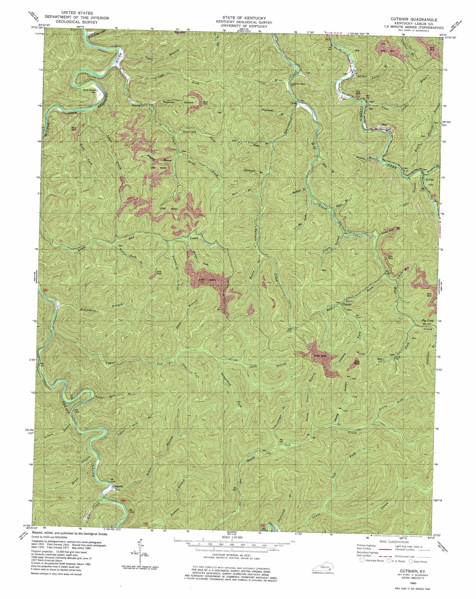
USGS Topo Quad 37083a3 - 1:24,000 scale
| Topo Map Name: | Cutshin |
| USGS Topo Quad ID: | 37083a3 |
| Print Size: | ca. 21 1/4" wide x 27" high |
| Southeast Coordinates: | 37° N latitude / 83.25° W longitude |
| Map Center Coordinates: | 37.0625° N latitude / 83.3125° W longitude |
| U.S. State: | KY |
| Filename: | o37083a3.jpg |
| Download Map JPG Image: | Cutshin topo map 1:24,000 scale |
| Map Type: | Topographic |
| Topo Series: | 7.5´ |
| Map Scale: | 1:24,000 |
| Source of Map Images: | United States Geological Survey (USGS) |
| Alternate Map Versions: |
Cutshin KY 1954, updated 1956 Download PDF Buy paper map Cutshin KY 1954, updated 1967 Download PDF Buy paper map Cutshin KY 1980, updated 1980 Download PDF Buy paper map Cutshin KY 2011 Download PDF Buy paper map Cutshin KY 2013 Download PDF Buy paper map Cutshin KY 2016 Download PDF Buy paper map |
| FStopo: | US Forest Service topo Cutshin is available: Download FStopo PDF Download FStopo TIF |
1:24,000 Topo Quads surrounding Cutshin
Mistletoe |
Buckhorn |
Krypton |
Hazard North |
Carrie |
Big Creek |
Hyden West |
Hyden East |
Hazard South |
Vicco |
Creekville |
Hoskinston |
Cutshin |
Leatherwood |
Tilford |
Beverly |
Helton |
Bledsoe |
Nolansburg |
Louellen |
Balkan |
Wallins Creek |
Harlan |
Evarts |
Pennington Gap |
> Back to 37083a1 at 1:100,000 scale
> Back to 37082a1 at 1:250,000 scale
> Back to U.S. Topo Maps home
Cutshin topo map: Gazetteer
Cutshin: Flats
Hardys Bottom elevation 380m 1246′Cutshin: Populated Places
Causey elevation 436m 1430′Chappell elevation 315m 1033′
Cinda elevation 301m 987′
Cutshin elevation 309m 1013′
Cutshin: Post Offices
Big Fork Post Office (historical) elevation 450m 1476′Camp Creek Post Office (historical) elevation 268m 879′
Causey Post Office (historical) elevation 436m 1430′
Chapel Post Office elevation 314m 1030′
Cinda Post Office (historical) elevation 300m 984′
Cutshin Post Office (historical) elevation 306m 1003′
Haywood Post Office (historical) elevation 292m 958′
Pennington Post Office (historical) elevation 443m 1453′
Sinda Post Office (historical) elevation 330m 1082′
Whiting Post Office (historical) elevation 422m 1384′
Cutshin: Streams
Ague Branch elevation 395m 1295′Baker Fork elevation 396m 1299′
Bear Branch elevation 347m 1138′
Beatty Fork elevation 433m 1420′
Bee Fork elevation 337m 1105′
Beech Bottom Branch elevation 300m 984′
Big Fork elevation 432m 1417′
Bills Branch elevation 311m 1020′
Bonnet Rock Branch elevation 387m 1269′
Camp Creek elevation 268m 879′
Coal Branch elevation 268m 879′
Cow Fork elevation 399m 1309′
Deadening Fork elevation 404m 1325′
Double Rock Branch elevation 372m 1220′
Elk Creek elevation 315m 1033′
Garrison Fork elevation 329m 1079′
Grassy Branch elevation 306m 1003′
Grassy Fork elevation 457m 1499′
Hendrix Branch elevation 299m 980′
Hensley Branch elevation 343m 1125′
Honey Branch elevation 315m 1033′
Hurricane Creek elevation 261m 856′
Jerrys Branch elevation 299m 980′
Johns Creek elevation 266m 872′
Lane Branch elevation 302m 990′
Larkin Lewis Branch elevation 292m 958′
Left Fork Camp Creek elevation 273m 895′
Left Fork Lewis Creek elevation 374m 1227′
Level Branch elevation 441m 1446′
Levi Lewis Branch elevation 291m 954′
Long Fork elevation 328m 1076′
Lower Bent Branch elevation 300m 984′
Maggard Branch elevation 304m 997′
Marion Fork elevation 413m 1354′
Mathias Branch elevation 325m 1066′
Muncy Branch elevation 374m 1227′
Myra Branch elevation 403m 1322′
Paces Trace Branch elevation 410m 1345′
Peters Branch elevation 349m 1145′
Poundmill Branch elevation 326m 1069′
Right Fork Johns Creek elevation 277m 908′
Robin Branch elevation 310m 1017′
Roundhole Branch elevation 287m 941′
Schoolhouse Branch elevation 389m 1276′
Signboard Branch elevation 328m 1076′
Tantrough Branch elevation 344m 1128′
Templeton Fork elevation 414m 1358′
Thad Branch elevation 342m 1122′
Trace Branch elevation 332m 1089′
Upper Bad Creek elevation 293m 961′
Upper Bent Branch elevation 312m 1023′
Wilder Branch elevation 296m 971′
Wolf Creek elevation 301m 987′
Cutshin: Valleys
Motts Hollow elevation 420m 1377′Raccoon Hollow elevation 305m 1000′
Cutshin digital topo map on disk
Buy this Cutshin topo map showing relief, roads, GPS coordinates and other geographical features, as a high-resolution digital map file on DVD:
Western Virginia & Southern West Virginia
Buy digital topo maps: Western Virginia & Southern West Virginia