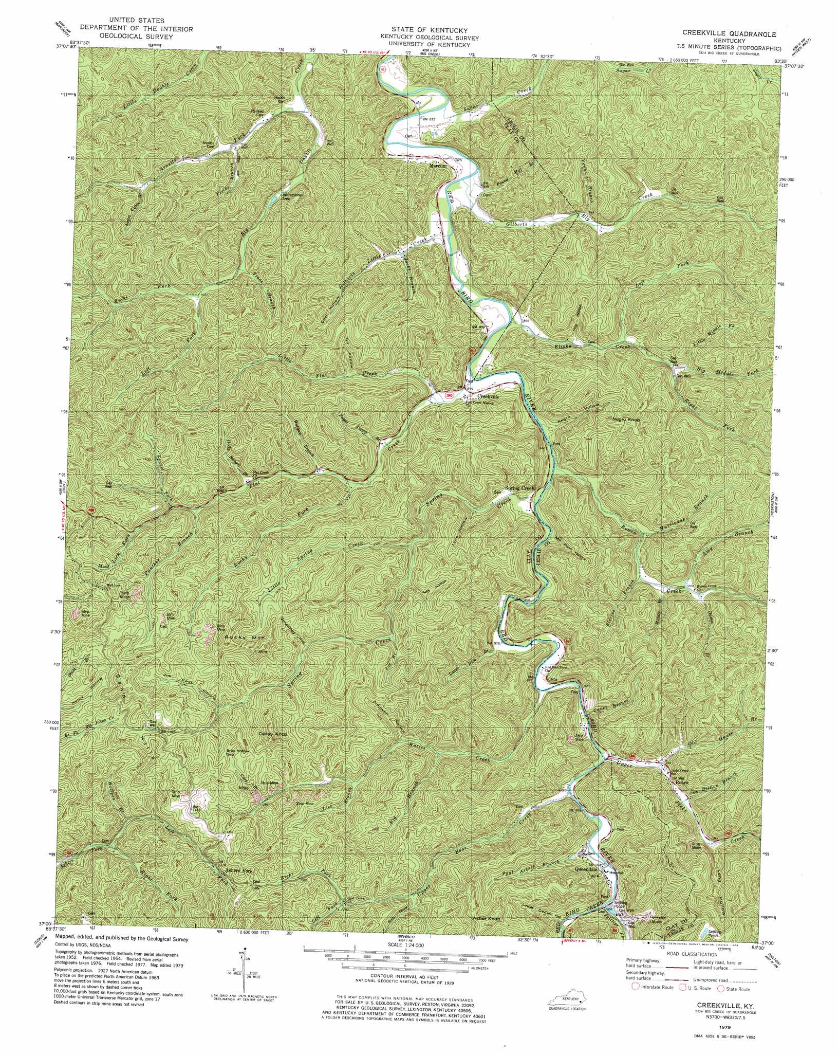
Creekville Topo Map Kentucky
To zoom in, hover over the map of Creekville
USGS Topo Quad 37083a5 - 1:24,000 scale
| Topo Map Name: | Creekville |
| USGS Topo Quad ID: | 37083a5 |
| Print Size: | ca. 21 1/4" wide x 27" high |
| Southeast Coordinates: | 37° N latitude / 83.5° W longitude |
| Map Center Coordinates: | 37.0625° N latitude / 83.5625° W longitude |
| U.S. State: | KY |
| Filename: | o37083a5.jpg |
| Download Map JPG Image: | Creekville topo map 1:24,000 scale |
| Map Type: | Topographic |
| Topo Series: | 7.5´ |
| Map Scale: | 1:24,000 |
| Source of Map Images: | United States Geological Survey (USGS) |
| Alternate Map Versions: |
Creekville KY 1954, updated 1956 Download PDF Buy paper map Creekville KY 1954, updated 1971 Download PDF Buy paper map Creekville KY 1979, updated 1979 Download PDF Buy paper map Creekville KY 2011 Download PDF Buy paper map Creekville KY 2013 Download PDF Buy paper map Creekville KY 2016 Download PDF Buy paper map |
| FStopo: | US Forest Service topo Creekville is available: Download FStopo PDF Download FStopo TIF |
1:24,000 Topo Quads surrounding Creekville
Maulden |
Oneida |
Mistletoe |
Buckhorn |
Krypton |
Manchester |
Barcreek |
Big Creek |
Hyden West |
Hyden East |
Hima |
Ogle |
Creekville |
Hoskinston |
Cutshin |
Fount |
Scalf |
Beverly |
Helton |
Bledsoe |
Artemus |
Pineville |
Balkan |
Wallins Creek |
Harlan |
> Back to 37083a1 at 1:100,000 scale
> Back to 37082a1 at 1:250,000 scale
> Back to U.S. Topo Maps home
Creekville topo map: Gazetteer
Creekville: Gaps
Brier Hollow Gap elevation 472m 1548′Creekville: Parks
Redbird Wildlife Management Area elevation 500m 1640′Creekville: Populated Places
Ashers Fork elevation 426m 1397′Creekville elevation 296m 971′
Marcum elevation 271m 889′
Queendale elevation 314m 1030′
Roark elevation 318m 1043′
Spring Creek elevation 281m 921′
Creekville: Post Offices
Asher Fork Post Office (historical) elevation 419m 1374′Creekville Post Office (historical) elevation 297m 974′
Marcum Post Office (historical) elevation 278m 912′
Roark Post Office elevation 317m 1040′
Skidmore Post Office (historical) elevation 307m 1007′
Spring Creek Post Office (historical) elevation 280m 918′
Van Camp Post Office (historical) elevation 296m 971′
Creekville: Streams
Amy Branch elevation 305m 1000′Arnetts Fork elevation 273m 895′
Big Branch elevation 328m 1076′
Big Middle Fork Elisha Creek elevation 298m 977′
Blevins Branch elevation 299m 980′
Bowen Creek elevation 284m 931′
Caney Branch elevation 293m 961′
Cave Branch elevation 391m 1282′
Daniel Branch elevation 311m 1020′
Deer Lick Branch elevation 372m 1220′
Deer Lick Branch elevation 375m 1230′
Dillion Branch elevation 307m 1007′
Elisha Creek elevation 269m 882′
Fields Branch elevation 295m 967′
Flat Creek elevation 270m 885′
Gilberts Big Creek elevation 265m 869′
Gilberts Little Creek elevation 264m 866′
Holly Bottom Branch elevation 316m 1036′
Hurricane Branch elevation 292m 958′
Jacks Branch elevation 307m 1007′
Joe Branch elevation 450m 1476′
Katies Creek elevation 289m 948′
Laurel Fork elevation 361m 1184′
Left Fork Ashers Fork elevation 339m 1112′
Left Fork Big Double Creek elevation 313m 1026′
Left Fork Elisha Creek elevation 288m 944′
Left Fork Upper Bear Creek elevation 390m 1279′
Little Flat Creek elevation 277m 908′
Little Middle Fork Elisha Creek elevation 306m 1003′
Little Spring Creek elevation 330m 1082′
Lower Rich Branch elevation 280m 918′
Middle Branch Bowen Creek elevation 302m 990′
Mud Lick Fork elevation 359m 1177′
Negro Cabin Branch elevation 324m 1062′
Old House Branch elevation 301m 987′
Panther Branch elevation 347m 1138′
Paul Ashers Branch elevation 300m 984′
Phillips Fork elevation 302m 990′
Pound Mill Branch elevation 267m 875′
Red Bird Creek elevation 302m 990′
Right Fork Ashers Fork elevation 339m 1112′
Right Fork Big Double Creek elevation 312m 1023′
Right Fork Elisha Creek elevation 300m 984′
Right Fork Upper Bear Creek elevation 390m 1279′
Rocklick Branch elevation 340m 1115′
Rocky Fork elevation 297m 974′
Spring Creek elevation 279m 915′
Sugar Camp Branch elevation 285m 935′
Sugar Creek elevation 264m 866′
Trace Branch elevation 302m 990′
Upper Bear Creek elevation 294m 964′
Upper Jacks Creek elevation 296m 971′
Venus Branch elevation 284m 931′
Wolfpen Branch elevation 301m 987′
Wolfpen Branch elevation 357m 1171′
Creekville: Summits
Asher Knob elevation 585m 1919′Caney Knob elevation 563m 1847′
Hoskins Knob elevation 486m 1594′
Negro Knob elevation 514m 1686′
Rocky Mountain elevation 556m 1824′
Sand Hills elevation 502m 1646′
Creekville: Trails
Redbird Crest Trail elevation 488m 1601′Creekville: Valleys
Coal Hollow elevation 336m 1102′Dimpson Hollow elevation 344m 1128′
Groundhog Hollow elevation 383m 1256′
Het Hollow elevation 358m 1174′
Hog Hollow elevation 284m 931′
Ivy Hollow elevation 316m 1036′
Jim Cove Hollow elevation 399m 1309′
Long Hollow elevation 326m 1069′
Lower DeZarn Hollow elevation 305m 1000′
Lynn Hollow elevation 300m 984′
Mill Pond Hollow elevation 295m 967′
Negro Hollow elevation 279m 915′
Rich Cove Hollow elevation 386m 1266′
Creekville digital topo map on disk
Buy this Creekville topo map showing relief, roads, GPS coordinates and other geographical features, as a high-resolution digital map file on DVD:
Western Virginia & Southern West Virginia
Buy digital topo maps: Western Virginia & Southern West Virginia