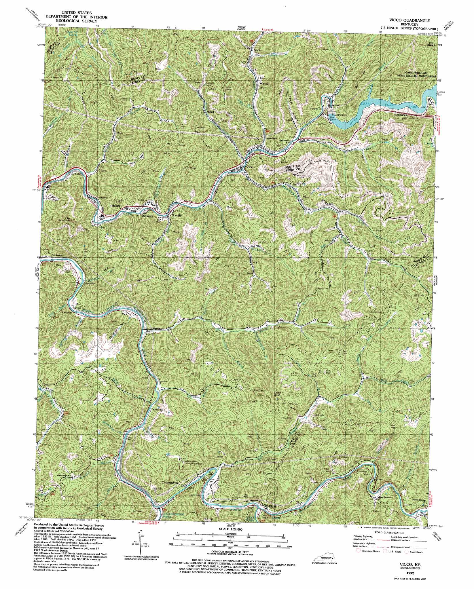
Vicco Topo Map Kentucky
To zoom in, hover over the map of Vicco
USGS Topo Quad 37083b1 - 1:24,000 scale
| Topo Map Name: | Vicco |
| USGS Topo Quad ID: | 37083b1 |
| Print Size: | ca. 21 1/4" wide x 27" high |
| Southeast Coordinates: | 37.125° N latitude / 83° W longitude |
| Map Center Coordinates: | 37.1875° N latitude / 83.0625° W longitude |
| U.S. State: | KY |
| Filename: | o37083b1.jpg |
| Download Map JPG Image: | Vicco topo map 1:24,000 scale |
| Map Type: | Topographic |
| Topo Series: | 7.5´ |
| Map Scale: | 1:24,000 |
| Source of Map Images: | United States Geological Survey (USGS) |
| Alternate Map Versions: |
Vicco KY 1954, updated 1956 Download PDF Buy paper map Vicco KY 1954, updated 1968 Download PDF Buy paper map Vicco KY 1954, updated 1978 Download PDF Buy paper map Vicco KY 1954, updated 1989 Download PDF Buy paper map Vicco KY 1992, updated 1992 Download PDF Buy paper map Vicco KY 2010 Download PDF Buy paper map Vicco KY 2013 Download PDF Buy paper map Vicco KY 2016 Download PDF Buy paper map |
1:24,000 Topo Quads surrounding Vicco
Haddix |
Noble |
Vest |
Handshoe |
Wayland |
Krypton |
Hazard North |
Carrie |
Hindman |
Kite |
Hyden East |
Hazard South |
Vicco |
Blackey |
Mayking |
Cutshin |
Leatherwood |
Tilford |
Roxana |
Whitesburg |
Bledsoe |
Nolansburg |
Louellen |
Benham |
Appalachia |
> Back to 37083a1 at 1:100,000 scale
> Back to 37082a1 at 1:250,000 scale
> Back to U.S. Topo Maps home
Vicco topo map: Gazetteer
Vicco: Bridges
Dakota Bridge elevation 276m 905′Vicco: Parks
Carr Creek State Park elevation 338m 1108′Carr Fork Lake State Wildlife Management Areas elevation 528m 1732′
Vicco: Populated Places
Acup elevation 338m 1108′Allock elevation 336m 1102′
Anco elevation 367m 1204′
Big Branch (historical) elevation 298m 977′
Carr Fork (historical) elevation 308m 1010′
Cornettsville elevation 284m 931′
Defiance elevation 291m 954′
Fuson elevation 295m 967′
Fusonia elevation 288m 944′
Happy elevation 285m 935′
Kodak elevation 334m 1095′
Sassafras elevation 289m 948′
Scuddy elevation 290m 951′
Ulvah elevation 302m 990′
Vicco elevation 287m 941′
Wiscoal elevation 343m 1125′
Vicco: Post Offices
Allock Post Office (historical) elevation 339m 1112′Anco Post Office (historical) elevation 395m 1295′
Barridge Post Office (historical) elevation 319m 1046′
Bluefield Post Office (historical) elevation 301m 987′
Brashearville Post Office (historical) elevation 281m 921′
Cornette Post Office (historical) elevation 292m 958′
Cornettsville Post Office elevation 286m 938′
Crow Post Office (historical) elevation 392m 1286′
Dakota Post Office (historical) elevation 283m 928′
Fort Branch Post Office (historical) elevation 289m 948′
Fusonia Post Office (historical) elevation 289m 948′
Gander Post Office (historical) elevation 511m 1676′
Gourd Post Office (historical) elevation 358m 1174′
Happy Post Office elevation 309m 1013′
Kodak Post Office (historical) elevation 327m 1072′
Salt Creek Post Office (historical) elevation 429m 1407′
Sassafras Post Office (historical) elevation 290m 951′
Scuddy Post Office (historical) elevation 288m 944′
Smithboro Post Office (historical) elevation 308m 1010′
Ulvah Post Office (historical) elevation 297m 974′
Ulvah Post Office (historical) elevation 291m 954′
Vicco: Reservoirs
Carr Fork Lake elevation 304m 997′Vicco: Streams
Acup Branch elevation 267m 875′Bear Branch elevation 278m 912′
Bee Branch elevation 382m 1253′
Big Branch elevation 277m 908′
Brushy Fork elevation 337m 1105′
Bull Creek elevation 285m 935′
Campbell Branch elevation 278m 912′
Dixon Branch elevation 326m 1069′
Doty Branch elevation 267m 875′
Dykes Branch elevation 280m 918′
Field Branch elevation 276m 905′
Firescald Branch elevation 364m 1194′
Fort Branch elevation 279m 915′
George Branch elevation 280m 918′
Hurricane Branch elevation 276m 905′
Hurt Fork elevation 311m 1020′
Kelly Branch elevation 316m 1036′
Kelly Fork elevation 327m 1072′
Leatherwood Creek elevation 278m 912′
Lick Fork elevation 351m 1151′
Lower Lick Fork elevation 365m 1197′
Mare Branch elevation 384m 1259′
Montgomery Creek elevation 286m 938′
Orchard Branch elevation 291m 954′
Orchard Branch elevation 278m 912′
Puncheoncamp Branch elevation 340m 1115′
Red Oak Branch elevation 290m 951′
Right Fork Montgomery Creek elevation 333m 1092′
Sassafras Creek elevation 292m 958′
Schoolhouse Branch elevation 278m 912′
Scuddy Branch elevation 277m 908′
Stacy Branch elevation 286m 938′
Straight Fork elevation 381m 1250′
Sugar Branch elevation 308m 1010′
Talent Branch elevation 293m 961′
Upper Lick Fork elevation 390m 1279′
Water Branch elevation 279m 915′
White Oak Branch elevation 275m 902′
Wicks Branch elevation 327m 1072′
Wooten Branch elevation 279m 915′
Yellow Creek elevation 286m 938′
Vicco: Summits
Dixon Knob elevation 659m 2162′Halls Mountain elevation 515m 1689′
Vicco: Valleys
McIntire Hollow elevation 283m 928′Rowdy Hollow elevation 291m 954′
Vicco digital topo map on disk
Buy this Vicco topo map showing relief, roads, GPS coordinates and other geographical features, as a high-resolution digital map file on DVD:
Western Virginia & Southern West Virginia
Buy digital topo maps: Western Virginia & Southern West Virginia