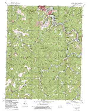
Hazard South Topo Map Kentucky
To zoom in, hover over the map of Hazard South
USGS Topo Quad 37083b2 - 1:24,000 scale
| Topo Map Name: | Hazard South |
| USGS Topo Quad ID: | 37083b2 |
| Print Size: | ca. 21 1/4" wide x 27" high |
| Southeast Coordinates: | 37.125° N latitude / 83.125° W longitude |
| Map Center Coordinates: | 37.1875° N latitude / 83.1875° W longitude |
| U.S. State: | KY |
| Filename: | o37083b2.jpg |
| Download Map JPG Image: | Hazard South topo map 1:24,000 scale |
| Map Type: | Topographic |
| Topo Series: | 7.5´ |
| Map Scale: | 1:24,000 |
| Source of Map Images: | United States Geological Survey (USGS) |
| Alternate Map Versions: |
Hazard South KY 1954, updated 1956 Download PDF Buy paper map Hazard South KY 1954, updated 1967 Download PDF Buy paper map Hazard South KY 1972, updated 1973 Download PDF Buy paper map Hazard South KY 1972, updated 1976 Download PDF Buy paper map Hazard South KY 1992, updated 1992 Download PDF Buy paper map Hazard South KY 2011 Download PDF Buy paper map Hazard South KY 2013 Download PDF Buy paper map Hazard South KY 2016 Download PDF Buy paper map |
| FStopo: | US Forest Service topo Hazard South is available: Download FStopo PDF Download FStopo TIF |
1:24,000 Topo Quads surrounding Hazard South
> Back to 37083a1 at 1:100,000 scale
> Back to 37082a1 at 1:250,000 scale
> Back to U.S. Topo Maps home
Hazard South topo map: Gazetteer
Hazard South: Mines
Candy Coal Mine elevation 279m 915′ECCO Coal Mine elevation 281m 921′
Hazard South: Populated Places
Browns Fork elevation 282m 925′Christopher elevation 270m 885′
Curly Fork elevation 313m 1026′
Daley elevation 333m 1092′
Diablock elevation 279m 915′
Dow elevation 312m 1023′
Eversole elevation 315m 1033′
Farler elevation 337m 1105′
Fourseam elevation 276m 905′
Frew elevation 322m 1056′
Glomawr elevation 276m 905′
Hazard elevation 283m 928′
Jeff elevation 279m 915′
Lothair elevation 267m 875′
Middle Fork elevation 319m 1046′
Viper elevation 275m 902′
Woodland Park elevation 268m 879′
Hazard South: Post Offices
Browns Fork Post Office (historical) elevation 280m 918′Christopher Post Office (historical) elevation 272m 892′
Daley Post Office (historical) elevation 326m 1069′
Diablock Post Office (historical) elevation 320m 1049′
Dow Post Office (historical) elevation 314m 1030′
Farler Post Office (historical) elevation 356m 1167′
Frew Post Office (historical) elevation 322m 1056′
Glomawr Post Office (historical) elevation 272m 892′
Hazard Post Office elevation 264m 866′
Jeff Post Office elevation 272m 892′
Kirby Post Office (historical) elevation 386m 1266′
Storm King Post Office (historical) elevation 290m 951′
Tana Post Office (historical) elevation 444m 1456′
Viper Post Office (historical) elevation 270m 885′
Hazard South: Streams
Bailey Branch elevation 338m 1108′Bear Branch elevation 264m 866′
Bear Branch elevation 324m 1062′
Bens Branch elevation 301m 987′
Big Branch elevation 307m 1007′
Buckeye Creek elevation 267m 875′
Buffalo Creek elevation 265m 869′
Buffalo Fork elevation 322m 1056′
Bull Fork elevation 328m 1076′
Campbell Branch elevation 277m 908′
Carr Fork elevation 267m 875′
Curly Fork elevation 271m 889′
Davidson Branch elevation 266m 872′
Elk Branch elevation 265m 869′
Elk Branch elevation 268m 879′
Elm Lick Fork elevation 286m 938′
Engle Branch elevation 266m 872′
Fields Fork elevation 337m 1105′
Four Seam Branch elevation 427m 1400′
Garman Branch elevation 266m 872′
Good Fork elevation 337m 1105′
Gregory Branch elevation 265m 869′
Hollythicket Branch elevation 303m 994′
Jacks Branch elevation 306m 1003′
Laurel Fork elevation 359m 1177′
Left Fork Maces Creek elevation 281m 921′
Lick Branch elevation 324m 1062′
Lick Fork elevation 322m 1056′
Maces Creek elevation 268m 879′
Messer Branch elevation 256m 839′
Middle Fork Maces Creek elevation 284m 931′
Minyard Branch elevation 311m 1020′
Negro Branch elevation 300m 984′
Peter Fork elevation 321m 1053′
Plumford Branch elevation 276m 905′
Polecat Branch elevation 311m 1020′
Poundmill Branch elevation 294m 964′
Raccoon Creek elevation 263m 862′
Richcoal Branch elevation 365m 1197′
Right Fork Buffalo Fork elevation 336m 1102′
Right Fork Maces Creek elevation 273m 895′
Riley Branch elevation 295m 967′
Rogers Branch elevation 375m 1230′
Saw Branch elevation 359m 1177′
Stratton Fork elevation 339m 1112′
Tackett Creek elevation 289m 948′
Wells Fork elevation 337m 1105′
Whitaker Fork elevation 287m 941′
Wolf Branch elevation 292m 958′
Wolf Fork elevation 365m 1197′
Wooly Fork elevation 291m 954′
Wooton Branch elevation 324m 1062′
Hazard South: Valleys
Big Rock Hollow elevation 364m 1194′Happy Hollow elevation 289m 948′
Sheep Hollow elevation 297m 974′
Stillhouse Hollow elevation 280m 918′
Talp Hollow elevation 328m 1076′
Hazard South digital topo map on disk
Buy this Hazard South topo map showing relief, roads, GPS coordinates and other geographical features, as a high-resolution digital map file on DVD:
Western Virginia & Southern West Virginia
Buy digital topo maps: Western Virginia & Southern West Virginia


