Manchester Topo Map Kentucky
To zoom in, hover over the map of Manchester
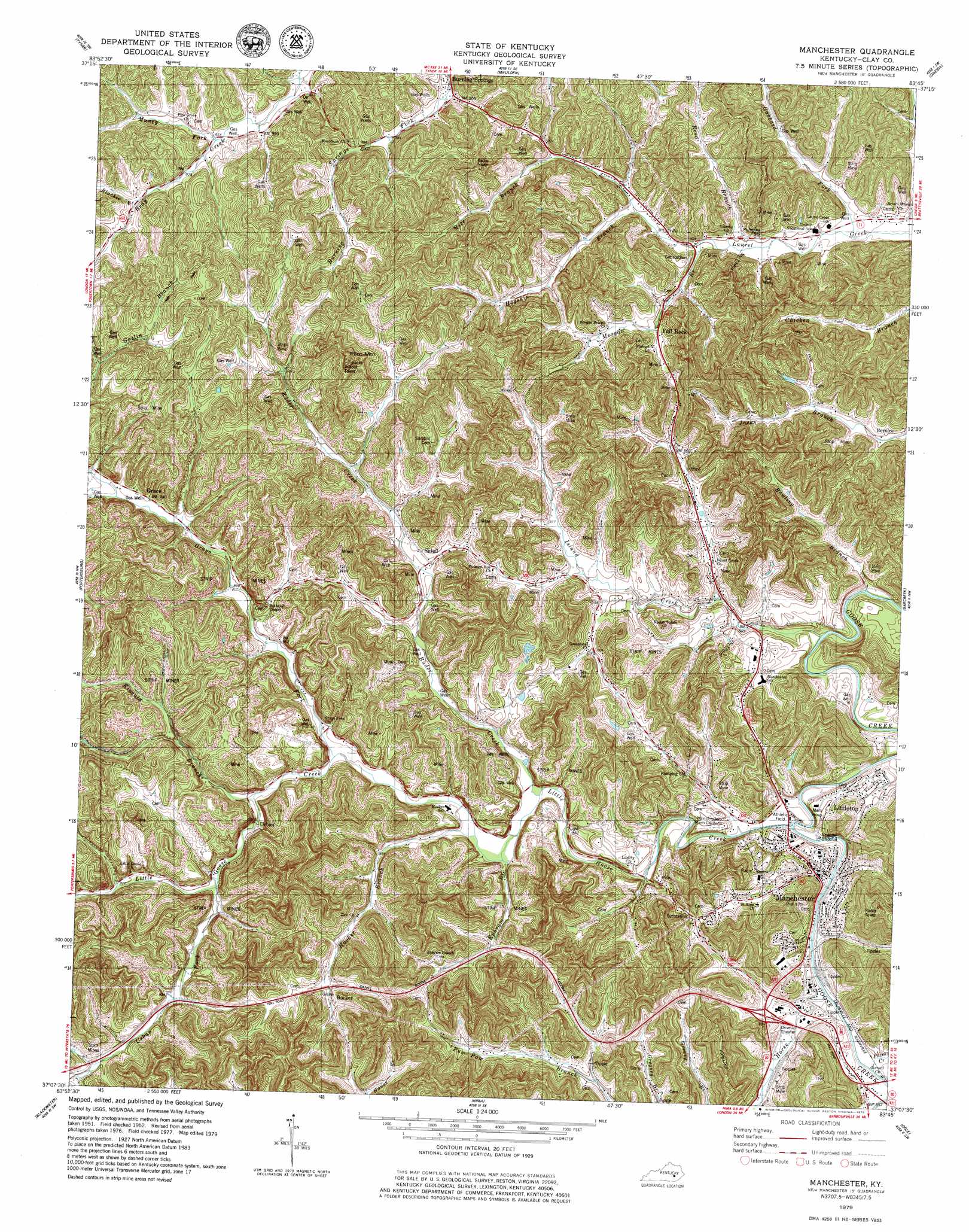
USGS Topo Quad 37083b7 - 1:24,000 scale
| Topo Map Name: | Manchester |
| USGS Topo Quad ID: | 37083b7 |
| Print Size: | ca. 21 1/4" wide x 27" high |
| Southeast Coordinates: | 37.125° N latitude / 83.75° W longitude |
| Map Center Coordinates: | 37.1875° N latitude / 83.8125° W longitude |
| U.S. State: | KY |
| Filename: | o37083b7.jpg |
| Download Map JPG Image: | Manchester topo map 1:24,000 scale |
| Map Type: | Topographic |
| Topo Series: | 7.5´ |
| Map Scale: | 1:24,000 |
| Source of Map Images: | United States Geological Survey (USGS) |
| Alternate Map Versions: |
Manchester KY 1952, updated 1954 Download PDF Buy paper map Manchester KY 1952, updated 1966 Download PDF Buy paper map Manchester KY 1979, updated 1979 Download PDF Buy paper map Manchester KY 2011 Download PDF Buy paper map Manchester KY 2013 Download PDF Buy paper map Manchester KY 2016 Download PDF Buy paper map |
| FStopo: | US Forest Service topo Manchester is available: Download FStopo PDF Download FStopo TIF |
1:24,000 Topo Quads surrounding Manchester
Sandgap |
Mckee |
Sturgeon |
Booneville |
Cowcreek |
Parrot |
Tyner |
Maulden |
Oneida |
Mistletoe |
London |
Portersburg |
Manchester |
Barcreek |
Big Creek |
Lily |
Blackwater |
Hima |
Ogle |
Creekville |
Corbin |
Heidrick |
Fount |
Scalf |
Beverly |
> Back to 37083a1 at 1:100,000 scale
> Back to 37082a1 at 1:250,000 scale
> Back to U.S. Topo Maps home
Manchester topo map: Gazetteer
Manchester: Areas
Manchester Memorial Gardens elevation 276m 905′Manchester: Crossings
Gillian Ford elevation 255m 836′Manchester: Gaps
Coder Gap elevation 316m 1036′Spice Gap elevation 304m 997′
Manchester: Populated Places
Bernice elevation 272m 892′Burning Springs elevation 287m 941′
Fall Rock elevation 312m 1023′
Flatwoods elevation 313m 1026′
Grace elevation 288m 944′
Gray Fork elevation 266m 872′
Hooker elevation 298m 977′
Littleton elevation 275m 902′
Manchester elevation 265m 869′
Murry elevation 323m 1059′
Pleasant Valley elevation 293m 961′
Sidell elevation 301m 987′
Urban elevation 273m 895′
Manchester: Post Offices
Add Post Office (historical) elevation 261m 856′Bernice Post Office (historical) elevation 274m 898′
Caution Post Office (historical) elevation 275m 902′
East Manchester Post Office (historical) elevation 263m 862′
Fall Rock Post Office elevation 307m 1007′
Garrard Post Office elevation 260m 853′
Grace Post Office (historical) elevation 348m 1141′
Hollingsworth Post Office (historical) elevation 278m 912′
Hooker Post Office (historical) elevation 300m 984′
Ponder Post Office (historical) elevation 292m 958′
Sacker Gap Post Office (historical) elevation 319m 1046′
Sidell Post Office (historical) elevation 301m 987′
Sourwood Post Office (historical) elevation 329m 1079′
Tinker Post Office (historical) elevation 299m 980′
Urban Post Office (historical) elevation 272m 892′
Manchester: Streams
Blackie Branch elevation 308m 1010′Bowling Branch elevation 249m 816′
Buck Branch elevation 282m 925′
Ephram Branch elevation 259m 849′
Gabbard Fork elevation 265m 869′
Grays Fork elevation 269m 882′
Greenbriar Branch elevation 255m 836′
Hogskin Branch elevation 279m 915′
Hooker Branch elevation 258m 846′
Horse Creek elevation 256m 839′
Island Creek elevation 250m 820′
Kincaid Branch elevation 267m 875′
Little Goose Creek elevation 255m 836′
Mize Branch elevation 282m 925′
Morgan Branch elevation 274m 898′
Muncy Fork elevation 291m 954′
Needmore Branch elevation 258m 846′
Paces Creek elevation 255m 836′
Rader Creek elevation 258m 846′
Reed Branch elevation 271m 889′
Right Fork Island Creek elevation 266m 872′
Rock Gap Branch elevation 279m 915′
Sandlin Branch elevation 297m 974′
Shed Branch elevation 258m 846′
Shin Bone Branch elevation 280m 918′
Stone Coal Branch elevation 255m 836′
Tanyard Branch elevation 285m 935′
Tinker Branch elevation 301m 987′
Urban Fork elevation 271m 889′
Wells Branch elevation 292m 958′
Whitmore Branch elevation 283m 928′
Yeager Branch elevation 272m 892′
Manchester: Summits
Pilot Mountain elevation 464m 1522′Manchester: Valleys
Tanard Hollow elevation 270m 885′Manchester digital topo map on disk
Buy this Manchester topo map showing relief, roads, GPS coordinates and other geographical features, as a high-resolution digital map file on DVD:
Western Virginia & Southern West Virginia
Buy digital topo maps: Western Virginia & Southern West Virginia