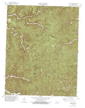
Mistletoe Topo Map Kentucky
To zoom in, hover over the map of Mistletoe
USGS Topo Quad 37083c5 - 1:24,000 scale
| Topo Map Name: | Mistletoe |
| USGS Topo Quad ID: | 37083c5 |
| Print Size: | ca. 21 1/4" wide x 27" high |
| Southeast Coordinates: | 37.25° N latitude / 83.5° W longitude |
| Map Center Coordinates: | 37.3125° N latitude / 83.5625° W longitude |
| U.S. State: | KY |
| Filename: | o37083c5.jpg |
| Download Map JPG Image: | Mistletoe topo map 1:24,000 scale |
| Map Type: | Topographic |
| Topo Series: | 7.5´ |
| Map Scale: | 1:24,000 |
| Source of Map Images: | United States Geological Survey (USGS) |
| Alternate Map Versions: |
Mistletoe KY 1953, updated 1955 Download PDF Buy paper map Mistletoe KY 1953, updated 1966 Download PDF Buy paper map Mistletoe KY 1979, updated 1979 Download PDF Buy paper map Mistletoe KY 2011 Download PDF Buy paper map Mistletoe KY 2013 Download PDF Buy paper map Mistletoe KY 2016 Download PDF Buy paper map |
| FStopo: | US Forest Service topo Mistletoe is available: Download FStopo PDF Download FStopo TIF |
1:24,000 Topo Quads surrounding Mistletoe
> Back to 37083a1 at 1:100,000 scale
> Back to 37082a1 at 1:250,000 scale
> Back to U.S. Topo Maps home
Mistletoe topo map: Gazetteer
Mistletoe: Capes
Panther Fork elevation 324m 1062′Mistletoe: Falls
Falls of Buffalo elevation 371m 1217′Mistletoe: Gaps
Deep Gap elevation 423m 1387′Locust Gap elevation 397m 1302′
Mistletoe: Populated Places
Couch Fork Neighborhood elevation 280m 918′Couch Town Neighborhood elevation 266m 872′
Dalesburg elevation 317m 1040′
Doorway elevation 319m 1046′
Lucky Fork elevation 283m 928′
Middle Squabble elevation 279m 915′
Mistletoe elevation 264m 866′
Rockhouse Neighborhood elevation 275m 902′
Sebastian elevation 237m 777′
Upper Squabble elevation 363m 1190′
Whoopflarea elevation 296m 971′
Mistletoe: Post Offices
Cortland Post Office elevation 281m 921′Doorway Post Office (historical) elevation 389m 1276′
Doorway Post Office (historical) elevation 319m 1046′
Gabbard Post Office elevation 239m 784′
Luck Fork Post Office (historical) elevation 278m 912′
Mistletoe Post Office elevation 263m 862′
Sebastian Post Office (historical) elevation 237m 777′
Seth Post Office (historical) elevation 254m 833′
Whoopflarea Post Office elevation 310m 1017′
Mistletoe: Ridges
Whoopflarea elevation 400m 1312′Mistletoe: Streams
Barbecue Branch elevation 309m 1013′Barn Branch elevation 274m 898′
Beatty Fork elevation 292m 958′
Big Branch elevation 371m 1217′
Big Branch elevation 299m 980′
Big Dan Branch elevation 269m 882′
Bill Oak Branch elevation 313m 1026′
Billy Branch elevation 265m 869′
Board Branch elevation 233m 764′
Brier Branch elevation 350m 1148′
Bunches Branch elevation 237m 777′
Cabin Branch elevation 272m 892′
Cherry Tree Branch elevation 291m 954′
Collins Branch elevation 257m 843′
Cortland Fork elevation 280m 918′
Davis Branch elevation 265m 869′
Deer Lick elevation 308m 1010′
Downey Branch elevation 261m 856′
Drench Branch elevation 283m 928′
Drowned Branch elevation 260m 853′
Dusty Fork elevation 322m 1056′
Enoch Fork elevation 293m 961′
Gabriel Fork elevation 274m 898′
Gay Branch elevation 359m 1177′
Guy Camp Branch elevation 237m 777′
Harrison Branch elevation 249m 816′
Jeff Branch elevation 283m 928′
Jeff Branch elevation 291m 954′
Jesse Branch elevation 269m 882′
Joyce Fork elevation 294m 964′
Keith Branch elevation 242m 793′
Laurel Fork elevation 247m 810′
Lick Branch elevation 266m 872′
Little McJonkin Branch elevation 299m 980′
Long Branch elevation 250m 820′
Long Fork elevation 328m 1076′
Lower Allen Branch elevation 254m 833′
Lower Twin Branch elevation 315m 1033′
Lucky Fork elevation 247m 810′
McJonkin Branch elevation 304m 997′
Meadow Branch elevation 251m 823′
Meadow Fork elevation 359m 1177′
Meadow Fork elevation 316m 1036′
Merill Branch elevation 287m 941′
Middle Allen Branch elevation 259m 849′
Mike Branch elevation 299m 980′
Mill Timber Branch elevation 276m 905′
Newberry Fork elevation 339m 1112′
Pig Pen Branch elevation 359m 1177′
Pig Pen Fork elevation 339m 1112′
Rattlesnake Creek elevation 239m 784′
Rockhouse Branch elevation 263m 862′
Schoolhouse Branch elevation 314m 1030′
Spruce Pine Fork elevation 277m 908′
Stable Branch elevation 297m 974′
Stable Hollow Branch elevation 267m 875′
Stamper Branch elevation 288m 944′
Steel Trap Branch elevation 281m 921′
Sugar Camp Branch elevation 259m 849′
Trace Branch elevation 262m 859′
Trace Branch elevation 242m 793′
Upper Allen Branch elevation 263m 862′
Upper Twin Branch elevation 316m 1036′
Watches Fork elevation 297m 974′
Wheatfield Branch elevation 259m 849′
Mistletoe: Summits
Bargers Knob elevation 507m 1663′Cherry Tree Knob elevation 515m 1689′
Cherry Tree Knob elevation 501m 1643′
Mistletoe: Valleys
Bald Head Hollow elevation 321m 1053′Blue John Hollow elevation 263m 862′
Ground Hog Hollow elevation 358m 1174′
Joe Hollow elevation 346m 1135′
Poplar Hollow elevation 300m 984′
Seng Cove elevation 347m 1138′
Still House Hollow elevation 300m 984′
Toenail Hollow elevation 342m 1122′
Mistletoe digital topo map on disk
Buy this Mistletoe topo map showing relief, roads, GPS coordinates and other geographical features, as a high-resolution digital map file on DVD:
Western Virginia & Southern West Virginia
Buy digital topo maps: Western Virginia & Southern West Virginia


