Maulden Topo Map Kentucky
To zoom in, hover over the map of Maulden
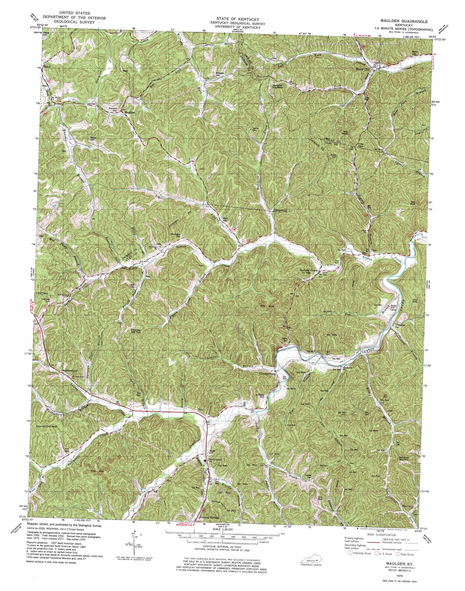
USGS Topo Quad 37083c7 - 1:24,000 scale
| Topo Map Name: | Maulden |
| USGS Topo Quad ID: | 37083c7 |
| Print Size: | ca. 21 1/4" wide x 27" high |
| Southeast Coordinates: | 37.25° N latitude / 83.75° W longitude |
| Map Center Coordinates: | 37.3125° N latitude / 83.8125° W longitude |
| U.S. State: | KY |
| Filename: | o37083c7.jpg |
| Download Map JPG Image: | Maulden topo map 1:24,000 scale |
| Map Type: | Topographic |
| Topo Series: | 7.5´ |
| Map Scale: | 1:24,000 |
| Source of Map Images: | United States Geological Survey (USGS) |
| Alternate Map Versions: |
Maulden KY 1954, updated 1955 Download PDF Buy paper map Maulden KY 1954, updated 1971 Download PDF Buy paper map Maulden KY 1979, updated 1979 Download PDF Buy paper map Maulden KY 2011 Download PDF Buy paper map Maulden KY 2013 Download PDF Buy paper map Maulden KY 2016 Download PDF Buy paper map |
| FStopo: | US Forest Service topo Maulden is available: Download FStopo PDF Download FStopo TIF |
1:24,000 Topo Quads surrounding Maulden
Alcorn |
Leighton |
Heidelberg |
Beattyville |
Tallega |
Sandgap |
Mckee |
Sturgeon |
Booneville |
Cowcreek |
Parrot |
Tyner |
Maulden |
Oneida |
Mistletoe |
London |
Portersburg |
Manchester |
Barcreek |
Big Creek |
Lily |
Blackwater |
Hima |
Ogle |
Creekville |
> Back to 37083a1 at 1:100,000 scale
> Back to 37082a1 at 1:250,000 scale
> Back to U.S. Topo Maps home
Maulden topo map: Gazetteer
Maulden: Gaps
Clay Gap elevation 317m 1040′Maulden: Populated Places
Chestnutburg elevation 254m 833′Island City elevation 255m 836′
Maulden elevation 316m 1036′
Mouth of Little Sextons Creek elevation 233m 764′
Sextons Creek elevation 249m 816′
Shepherdtown elevation 284m 931′
Sourwood elevation 265m 869′
Union elevation 315m 1033′
Vine elevation 299m 980′
Maulden: Post Offices
Chestnutburg Post Office (historical) elevation 257m 843′Dory Post Office (historical) elevation 249m 816′
Ethel Post Office (historical) elevation 260m 853′
Malcolm Post Office (historical) elevation 262m 859′
Nathanton Post Office (historical) elevation 308m 1010′
Sexton Creek Post Office elevation 233m 764′
Sextons Creek Post Office elevation 249m 816′
Vine Post Office (historical) elevation 287m 941′
Maulden: Ridges
Silvermine Ridge elevation 348m 1141′Maulden: Streams
Bray Creek elevation 255m 836′Brushy Branch elevation 271m 889′
Buckeye Branch elevation 295m 967′
Buncomb Creek elevation 250m 820′
Burning Springs Fork elevation 260m 853′
Cave Branch elevation 239m 784′
Chestnut Branch elevation 247m 810′
Clark Branch elevation 278m 912′
Cradlebow Branch elevation 237m 777′
Double Lick elevation 347m 1138′
Double Lick elevation 309m 1013′
Eds Lick elevation 301m 987′
Ells Branch elevation 238m 780′
Falling Timber Branch elevation 284m 931′
Fox Branch elevation 236m 774′
Fuston Branch elevation 274m 898′
Grassy Branch elevation 237m 777′
Gum Branch elevation 276m 905′
Herd Fork elevation 316m 1036′
Hog Camp Branch elevation 295m 967′
Holly Fork elevation 255m 836′
Huckleberry Branch elevation 268m 879′
Jims Branch elevation 240m 787′
Leger Fork elevation 257m 843′
Little Sexton Creek elevation 233m 764′
Maulden Branch elevation 316m 1036′
Opossum Trot Branch elevation 273m 895′
Pennington Fork elevation 287m 941′
Pigeon Roost Branch elevation 265m 869′
Pine Lick Branch elevation 283m 928′
Ponder Branch elevation 256m 839′
Robinsons Creek elevation 261m 856′
Rocky Branch elevation 280m 918′
Rocky Branch elevation 328m 1076′
Sacker Branch elevation 292m 958′
Sacker Creek elevation 253m 830′
Maulden: Valleys
Clark-Dun Well Hollow elevation 267m 875′Cope Hollow elevation 348m 1141′
Thomas Hollow elevation 294m 964′
Maulden digital topo map on disk
Buy this Maulden topo map showing relief, roads, GPS coordinates and other geographical features, as a high-resolution digital map file on DVD:
Western Virginia & Southern West Virginia
Buy digital topo maps: Western Virginia & Southern West Virginia