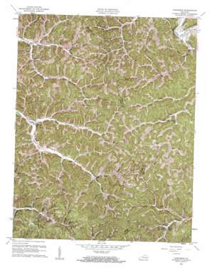
Cowcreek Topo Map Kentucky
To zoom in, hover over the map of Cowcreek
USGS Topo Quad 37083d5 - 1:24,000 scale
| Topo Map Name: | Cowcreek |
| USGS Topo Quad ID: | 37083d5 |
| Print Size: | ca. 21 1/4" wide x 27" high |
| Southeast Coordinates: | 37.375° N latitude / 83.5° W longitude |
| Map Center Coordinates: | 37.4375° N latitude / 83.5625° W longitude |
| U.S. State: | KY |
| Filename: | o37083d5.jpg |
| Download Map JPG Image: | Cowcreek topo map 1:24,000 scale |
| Map Type: | Topographic |
| Topo Series: | 7.5´ |
| Map Scale: | 1:24,000 |
| Source of Map Images: | United States Geological Survey (USGS) |
| Alternate Map Versions: |
Cowcreek KY 1953, updated 1954 Download PDF Buy paper map Cowcreek KY 1961, updated 1961 Download PDF Buy paper map Cowcreek KY 2011 Download PDF Buy paper map Cowcreek KY 2013 Download PDF Buy paper map Cowcreek KY 2016 Download PDF Buy paper map |
| FStopo: | US Forest Service topo Cowcreek is available: Download FStopo PDF Download FStopo TIF |
1:24,000 Topo Quads surrounding Cowcreek
> Back to 37083a1 at 1:100,000 scale
> Back to 37082a1 at 1:250,000 scale
> Back to U.S. Topo Maps home
Cowcreek topo map: Gazetteer
Cowcreek: Populated Places
Arnett elevation 249m 816′Cowcreek elevation 215m 705′
Hall Neighborhood elevation 260m 853′
Houston elevation 254m 833′
Indian Creek Neighborhood elevation 252m 826′
Lerose elevation 226m 741′
Morris Fork elevation 262m 859′
Ricetown elevation 249m 816′
Turkey elevation 213m 698′
Cowcreek: Post Offices
Arnett Post Office (historical) elevation 255m 836′Ash Post Office (historical) elevation 242m 793′
Cowcreek Post Office elevation 222m 728′
Lerose Post Office (historical) elevation 224m 734′
Mine Fork Post Office (historical) elevation 224m 734′
Ricetown Post Office (historical) elevation 246m 807′
Cowcreek: Streams
Amis Branch elevation 261m 856′Baker Branch elevation 268m 879′
Beech Fork elevation 223m 731′
Broker Branch elevation 249m 816′
Buck Fork elevation 273m 895′
Burton Fork elevation 244m 800′
Caney Branch elevation 239m 784′
Crane Fork elevation 231m 757′
Eversole Branch elevation 241m 790′
Grassy Branch elevation 258m 846′
Horn Branch elevation 274m 898′
Ikie Branch elevation 245m 803′
Ingol Fork elevation 249m 816′
Jennings Branch elevation 258m 846′
Left Fork Cow Creek elevation 213m 698′
Long Fork elevation 244m 800′
Mare Fork elevation 238m 780′
McIntosh Fork elevation 244m 800′
Moore Fork elevation 232m 761′
Morris Fork elevation 251m 823′
Poletown Fork elevation 223m 731′
Right Fork Cow Creek elevation 213m 698′
Right Fork Jetts Creek elevation 219m 718′
Riley Fork elevation 278m 912′
Roberts Fork elevation 248m 813′
Rose Fork elevation 247m 810′
Short Fork elevation 248m 813′
Smith Fork elevation 249m 816′
Spencer Fork elevation 247m 810′
Spencer Fork elevation 223m 731′
Split Poplar Fork elevation 260m 853′
Spruce Fork elevation 289m 948′
Stringtown Branch elevation 244m 800′
Ten Acre Fork elevation 258m 846′
Terry Branch elevation 238m 780′
Terry Fork elevation 209m 685′
Turkey Creek elevation 206m 675′
White Oak Fork elevation 267m 875′
Wilson Fork elevation 225m 738′
Zeke Branch elevation 220m 721′
Cowcreek: Summits
Rice Knob elevation 435m 1427′Rose Knob elevation 407m 1335′
Cowcreek: Valleys
Bug Hollow elevation 277m 908′Deadening Hollow elevation 216m 708′
Halcomb Hollow elevation 231m 757′
Pigpen Hollow elevation 272m 892′
Tabletree Hollow elevation 236m 774′
Wolfpen Hollow elevation 250m 820′
Cowcreek digital topo map on disk
Buy this Cowcreek topo map showing relief, roads, GPS coordinates and other geographical features, as a high-resolution digital map file on DVD:
Western Virginia & Southern West Virginia
Buy digital topo maps: Western Virginia & Southern West Virginia


