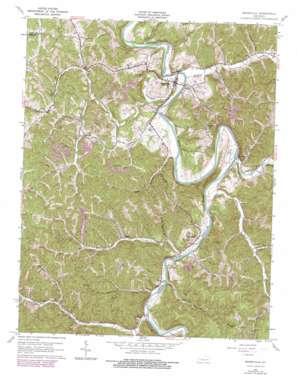
Booneville Topo Map Kentucky
To zoom in, hover over the map of Booneville
USGS Topo Quad 37083d6 - 1:24,000 scale
| Topo Map Name: | Booneville |
| USGS Topo Quad ID: | 37083d6 |
| Print Size: | ca. 21 1/4" wide x 27" high |
| Southeast Coordinates: | 37.375° N latitude / 83.625° W longitude |
| Map Center Coordinates: | 37.4375° N latitude / 83.6875° W longitude |
| U.S. State: | KY |
| Filename: | o37083d6.jpg |
| Download Map JPG Image: | Booneville topo map 1:24,000 scale |
| Map Type: | Topographic |
| Topo Series: | 7.5´ |
| Map Scale: | 1:24,000 |
| Source of Map Images: | United States Geological Survey (USGS) |
| Alternate Map Versions: |
Booneville KY 1953, updated 1955 Download PDF Buy paper map Booneville KY 1961, updated 1963 Download PDF Buy paper map Booneville KY 1961, updated 1976 Download PDF Buy paper map Booneville KY 1961, updated 1978 Download PDF Buy paper map Booneville KY 2011 Download PDF Buy paper map Booneville KY 2013 Download PDF Buy paper map Booneville KY 2016 Download PDF Buy paper map |
| FStopo: | US Forest Service topo Booneville is available: Download FStopo PDF Download FStopo TIF |
1:24,000 Topo Quads surrounding Booneville
> Back to 37083a1 at 1:100,000 scale
> Back to 37082a1 at 1:250,000 scale
> Back to U.S. Topo Maps home
Booneville topo map: Gazetteer
Booneville: Basins
The Sag elevation 208m 682′Booneville: Bends
Cawood Bend elevation 211m 692′Booneville: Pillars
Boones Rock elevation 305m 1000′Booneville: Populated Places
Blake elevation 251m 823′Booneville elevation 216m 708′
Chestnut Gap elevation 281m 921′
Chestnut Neighborhood elevation 279m 915′
Conkling elevation 225m 738′
Elk Lick Neighborhood elevation 283m 928′
Eversole elevation 211m 692′
Hogg Neighborhood elevation 230m 754′
Levi elevation 253m 830′
Major elevation 236m 774′
Pleasant Neighborhood elevation 278m 912′
Scoville elevation 261m 856′
Southfork elevation 218m 715′
Sugar Camp Neighborhood elevation 246m 807′
Booneville: Post Offices
Blake Post Office (historical) elevation 254m 833′Booneville Post Office elevation 207m 679′
Buck Creek Post Office (historical) elevation 285m 935′
Conkling Post Office elevation 212m 695′
Eversole Post Office elevation 225m 738′
Levi Post Office (historical) elevation 268m 879′
Major Post Office elevation 253m 830′
Posey Post Office (historical) elevation 262m 859′
Scoville Post Office (historical) elevation 263m 862′
Southfork Post Office elevation 215m 705′
Turin Post Office elevation 213m 698′
Booneville: Springs
Boone Spring elevation 201m 659′Booneville: Streams
Bear Run elevation 201m 659′Betty Bowman Creek elevation 200m 656′
Betty Thomas Branch elevation 213m 698′
Buck Creek elevation 199m 652′
Cow Creek elevation 201m 659′
Doe Creek elevation 207m 679′
Fish Creek elevation 199m 652′
Gabbard Branch elevation 224m 734′
Gilbert Branch elevation 207m 679′
Horse Branch elevation 248m 813′
Indian Creek elevation 206m 675′
Left Fork Island Creek elevation 213m 698′
Lower Island Creek elevation 206m 675′
Lower Wolf Creek elevation 204m 669′
McGuire Fork elevation 241m 790′
Meadow Creek elevation 201m 659′
Mill Town Branch elevation 199m 652′
Mud Lick elevation 270m 885′
Peachtree Branch elevation 268m 879′
Rowland Branch elevation 231m 757′
Sugar Camp Creek elevation 206m 675′
Upper Wolf Creek elevation 209m 685′
White Oak Creek elevation 204m 669′
Wolf Creek elevation 206m 675′
Booneville: Summits
High Rock Mountain elevation 312m 1023′Mine Knob elevation 323m 1059′
Turkey Knob elevation 357m 1171′
Booneville: Valleys
Greenville Hollow elevation 218m 715′Booneville digital topo map on disk
Buy this Booneville topo map showing relief, roads, GPS coordinates and other geographical features, as a high-resolution digital map file on DVD:
Western Virginia & Southern West Virginia
Buy digital topo maps: Western Virginia & Southern West Virginia


