Sturgeon Topo Map Kentucky
To zoom in, hover over the map of Sturgeon
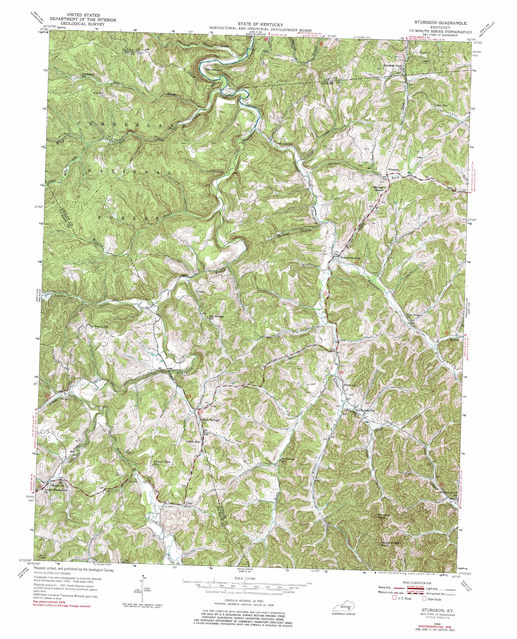
USGS Topo Quad 37083d7 - 1:24,000 scale
| Topo Map Name: | Sturgeon |
| USGS Topo Quad ID: | 37083d7 |
| Print Size: | ca. 21 1/4" wide x 27" high |
| Southeast Coordinates: | 37.375° N latitude / 83.75° W longitude |
| Map Center Coordinates: | 37.4375° N latitude / 83.8125° W longitude |
| U.S. State: | KY |
| Filename: | o37083d7.jpg |
| Download Map JPG Image: | Sturgeon topo map 1:24,000 scale |
| Map Type: | Topographic |
| Topo Series: | 7.5´ |
| Map Scale: | 1:24,000 |
| Source of Map Images: | United States Geological Survey (USGS) |
| Alternate Map Versions: |
Sturgeon KY 1953, updated 1955 Download PDF Buy paper map Sturgeon KY 1953, updated 1966 Download PDF Buy paper map Sturgeon KY 1953, updated 1978 Download PDF Buy paper map Sturgeon KY 1953, updated 1983 Download PDF Buy paper map Sturgeon KY 2011 Download PDF Buy paper map Sturgeon KY 2013 Download PDF Buy paper map Sturgeon KY 2016 Download PDF Buy paper map |
| FStopo: | US Forest Service topo Sturgeon is available: Download FStopo PDF Download FStopo TIF |
1:24,000 Topo Quads surrounding Sturgeon
Panola |
Irvine |
Cobhill |
Zachariah |
Campton |
Alcorn |
Leighton |
Heidelberg |
Beattyville |
Tallega |
Sandgap |
Mckee |
Sturgeon |
Booneville |
Cowcreek |
Parrot |
Tyner |
Maulden |
Oneida |
Mistletoe |
London |
Portersburg |
Manchester |
Barcreek |
Big Creek |
> Back to 37083a1 at 1:100,000 scale
> Back to 37082a1 at 1:250,000 scale
> Back to U.S. Topo Maps home
Sturgeon topo map: Gazetteer
Sturgeon: Parks
High Rock elevation 274m 898′Sturgeon: Populated Places
Big Spring Neighborhood elevation 300m 984′Brewer Neighborhood elevation 268m 879′
Elias elevation 313m 1026′
Endee elevation 314m 1030′
Hickory Flat elevation 368m 1207′
Moors Neighborhood elevation 234m 767′
Mummie elevation 304m 997′
Needmore Neighborhood elevation 311m 1020′
Rock Spring Neighborhood elevation 297m 974′
Sturgeon elevation 277m 908′
Travellers Rest elevation 258m 846′
Travis elevation 271m 889′
Vincent elevation 309m 1013′
Sturgeon: Post Offices
Botner Post Office (historical) elevation 300m 984′Brewer Post Office (historical) elevation 271m 889′
Chadwell Post Office (historical) elevation 280m 918′
Earnestville Post Office (historical) elevation 226m 741′
Elias Post Office (historical) elevation 313m 1026′
Endee Post Office (historical) elevation 286m 938′
Green Hall Post Office (historical) elevation 311m 1020′
Greenhill Post Office elevation 302m 990′
Lynch Post Office (historical) elevation 276m 905′
Mummie Post Office (historical) elevation 308m 1010′
Powell Post Office (historical) elevation 262m 859′
Sturgeon Post Office (historical) elevation 280m 918′
Travelers Rest Post Office (historical) elevation 259m 849′
Vincent Post Office elevation 312m 1023′
Sturgeon: Streams
Beals Fork elevation 274m 898′Blackwater Creek elevation 280m 918′
Brewer Fork elevation 286m 938′
Brushy Creek elevation 243m 797′
Crane Creek elevation 232m 761′
Dry Fork elevation 233m 764′
Granny Dismal Creek elevation 219m 718′
Grassy Creek elevation 280m 918′
Hartsock Branch elevation 249m 816′
Little Sturgeon Creek elevation 231m 757′
Little Wild Dog Creek elevation 280m 918′
Mills Branch elevation 287m 941′
Rowlette Branch elevation 261m 856′
Spruce Fork elevation 237m 777′
Travis Creek elevation 256m 839′
Warren Chapel Branch elevation 257m 843′
Wild Dog Creek elevation 225m 738′
Wilfreds Fork elevation 298m 977′
Wilson Fork elevation 280m 918′
Wolf Pen Creek elevation 292m 958′
Sturgeon: Summits
Hunters Knob elevation 418m 1371′Island Creek Knob elevation 429m 1407′
Sturgeon digital topo map on disk
Buy this Sturgeon topo map showing relief, roads, GPS coordinates and other geographical features, as a high-resolution digital map file on DVD:
Western Virginia & Southern West Virginia
Buy digital topo maps: Western Virginia & Southern West Virginia