Guage Topo Map Kentucky
To zoom in, hover over the map of Guage
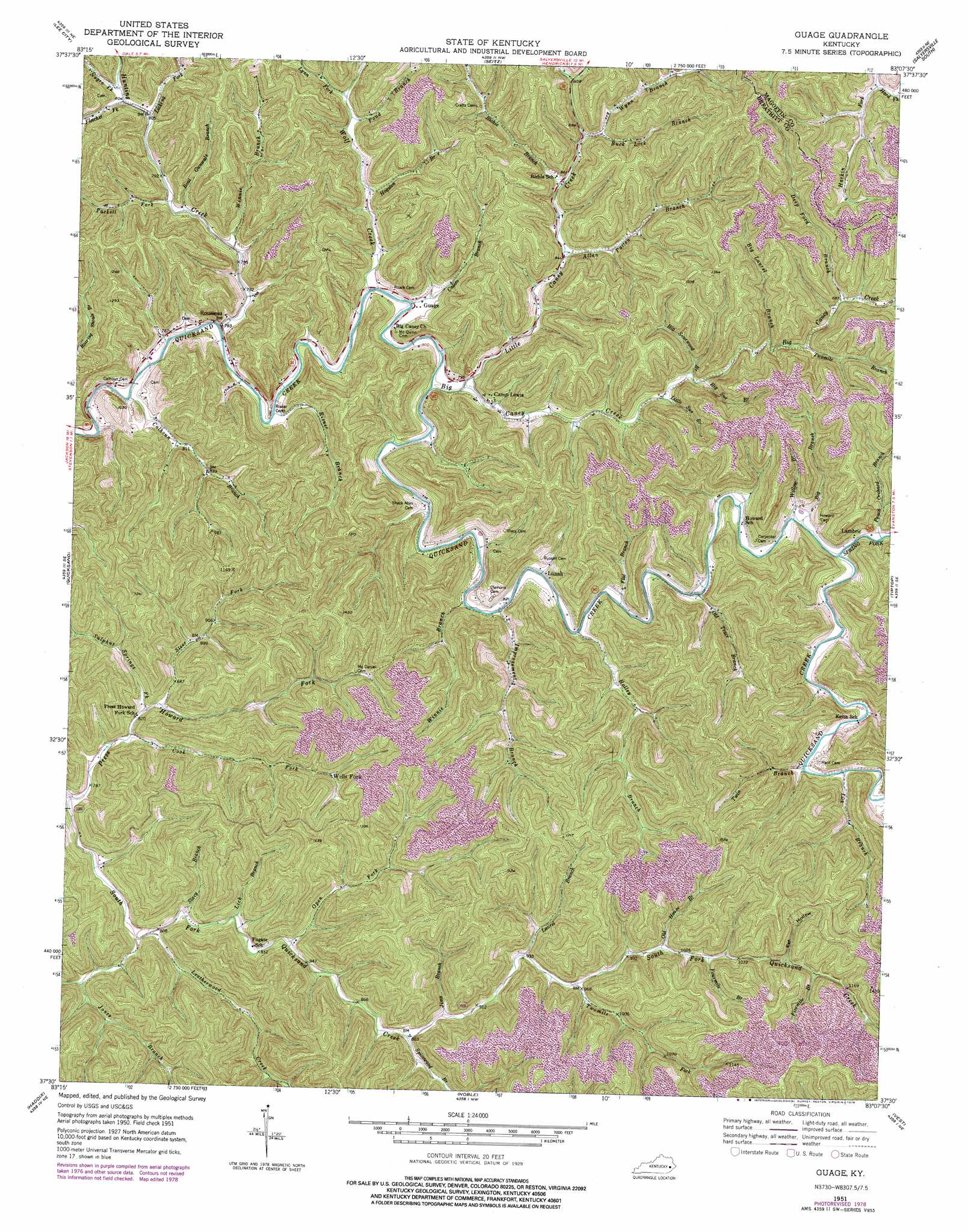
USGS Topo Quad 37083e2 - 1:24,000 scale
| Topo Map Name: | Guage |
| USGS Topo Quad ID: | 37083e2 |
| Print Size: | ca. 21 1/4" wide x 27" high |
| Southeast Coordinates: | 37.5° N latitude / 83.125° W longitude |
| Map Center Coordinates: | 37.5625° N latitude / 83.1875° W longitude |
| U.S. State: | KY |
| Filename: | o37083e2.jpg |
| Download Map JPG Image: | Guage topo map 1:24,000 scale |
| Map Type: | Topographic |
| Topo Series: | 7.5´ |
| Map Scale: | 1:24,000 |
| Source of Map Images: | United States Geological Survey (USGS) |
| Alternate Map Versions: |
Guage KY 1951, updated 1952 Download PDF Buy paper map Guage KY 1951, updated 1969 Download PDF Buy paper map Guage KY 1951, updated 1977 Download PDF Buy paper map Guage KY 1951, updated 1978 Download PDF Buy paper map Guage KY 2010 Download PDF Buy paper map Guage KY 2013 Download PDF Buy paper map Guage KY 2016 Download PDF Buy paper map |
1:24,000 Topo Quads surrounding Guage
Hazel Green |
Cannel City |
White Oak |
Salyersville North |
Oil Springs |
Landsaw |
Lee City |
Seitz |
Salyersville South |
Ivyton |
Jackson |
Quicksand |
Guage |
Tiptop |
David |
Canoe |
Haddix |
Noble |
Vest |
Handshoe |
Buckhorn |
Krypton |
Hazard North |
Carrie |
Hindman |
> Back to 37083e1 at 1:100,000 scale
> Back to 37082a1 at 1:250,000 scale
> Back to U.S. Topo Maps home
Guage topo map: Gazetteer
Guage: Populated Places
Guage elevation 240m 787′Lambric elevation 258m 846′
Lunah elevation 246m 807′
Rousseau elevation 237m 777′
Wells Fork elevation 305m 1000′
Guage: Streams
Allen Patton Branch elevation 252m 826′Alum Cave Branch elevation 252m 826′
Big Branch elevation 254m 833′
Big Caney Creek elevation 234m 767′
Big Laurel Branch elevation 266m 872′
Big Sourwood Branch elevation 255m 836′
Big Sue Branch elevation 257m 843′
Boat Gunwale Branch elevation 240m 787′
Buck Lick Branch elevation 265m 869′
Calhoun Branch elevation 231m 757′
Calico Branch elevation 238m 780′
Cook Fork elevation 246m 807′
Deep Ford Branch elevation 272m 892′
Fivemile Branch elevation 349m 1145′
Flat Branch elevation 244m 800′
Fletcher Fork elevation 245m 803′
Fourmile Branch elevation 319m 1046′
Hade Fork elevation 262m 859′
Hard Fork elevation 291m 954′
Harkin Fork elevation 291m 954′
Hogston Branch elevation 249m 816′
Holley Branch elevation 244m 800′
Hunting Creek elevation 233m 764′
Improvement Branch elevation 241m 790′
Jims Branch elevation 273m 895′
Jones Branch elevation 243m 797′
Laurel Branch elevation 287m 941′
Leatherwood Creek elevation 244m 800′
Lick Branch elevation 255m 836′
Lick Branch elevation 249m 816′
Licking Fork elevation 242m 793′
Little Caney Creek elevation 237m 777′
Little Sue Branch elevation 252m 826′
Lynn Fork elevation 265m 869′
Negro Fork elevation 246m 807′
Old House Branch elevation 310m 1017′
Old Trace Branch elevation 247m 810′
Open Fork elevation 255m 836′
Peach Orchard Branch elevation 254m 833′
Pond Branch elevation 260m 853′
Richie Branch elevation 259m 849′
Risner Branch elevation 233m 764′
Spicewood Branch elevation 268m 879′
Spring Fork Quicksand Creek elevation 250m 820′
Stacy Branch elevation 247m 810′
Steer Fork elevation 254m 833′
Sulphur Springs Fork elevation 250m 820′
Tackett Fork elevation 240m 787′
Twin Branch elevation 254m 833′
Twomile Branch elevation 268m 879′
Twomile Fork elevation 291m 954′
Willow Branch elevation 248m 813′
Winnie Branch elevation 237m 777′
Winnie Branch elevation 239m 784′
Wolf Creek elevation 235m 770′
Wynn Branch elevation 271m 889′
Guage: Valleys
Eaf Hollow elevation 340m 1115′Guage digital topo map on disk
Buy this Guage topo map showing relief, roads, GPS coordinates and other geographical features, as a high-resolution digital map file on DVD:
Western Virginia & Southern West Virginia
Buy digital topo maps: Western Virginia & Southern West Virginia