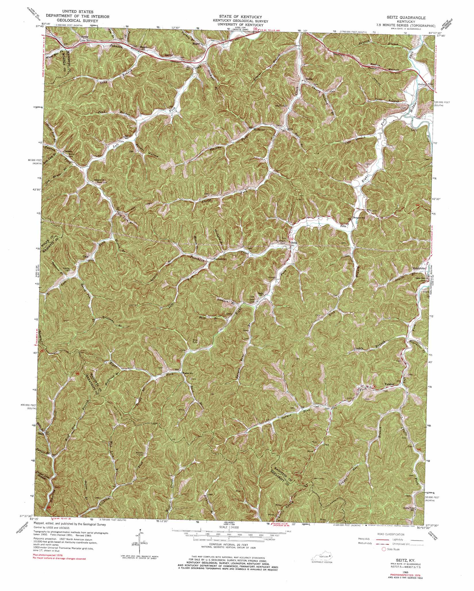
Seitz Topo Map Kentucky
To zoom in, hover over the map of Seitz
USGS Topo Quad 37083f2 - 1:24,000 scale
| Topo Map Name: | Seitz |
| USGS Topo Quad ID: | 37083f2 |
| Print Size: | ca. 21 1/4" wide x 27" high |
| Southeast Coordinates: | 37.625° N latitude / 83.125° W longitude |
| Map Center Coordinates: | 37.6875° N latitude / 83.1875° W longitude |
| U.S. State: | KY |
| Filename: | o37083f2.jpg |
| Download Map JPG Image: | Seitz topo map 1:24,000 scale |
| Map Type: | Topographic |
| Topo Series: | 7.5´ |
| Map Scale: | 1:24,000 |
| Source of Map Images: | United States Geological Survey (USGS) |
| Alternate Map Versions: |
Seitz KY 1951, updated 1953 Download PDF Buy paper map Seitz KY 1965, updated 1967 Download PDF Buy paper map Seitz KY 1965, updated 1978 Download PDF Buy paper map Seitz KY 2010 Download PDF Buy paper map Seitz KY 2013 Download PDF Buy paper map Seitz KY 2016 Download PDF Buy paper map |
1:24,000 Topo Quads surrounding Seitz
Ezel |
West Liberty |
Lenox |
Dingus |
Redbush |
Hazel Green |
Cannel City |
White Oak |
Salyersville North |
Oil Springs |
Landsaw |
Lee City |
Seitz |
Salyersville South |
Ivyton |
Jackson |
Quicksand |
Guage |
Tiptop |
David |
Canoe |
Haddix |
Noble |
Vest |
Handshoe |
> Back to 37083e1 at 1:100,000 scale
> Back to 37082a1 at 1:250,000 scale
> Back to U.S. Topo Maps home
Seitz topo map: Gazetteer
Seitz: Flats
Bunker Bottom Flat elevation 267m 875′Seitz: Populated Places
Bays elevation 271m 889′Craft Fork elevation 287m 941′
Cutuno elevation 278m 912′
Dale elevation 283m 928′
Epson elevation 261m 856′
Foraker elevation 272m 892′
Fritz elevation 268m 879′
Gullett elevation 260m 853′
Hager elevation 258m 846′
Netty elevation 265m 869′
Ova elevation 268m 879′
Puncheon elevation 321m 1053′
Right Middle Fork elevation 296m 971′
Seitz elevation 270m 885′
Stella elevation 266m 872′
Seitz: Post Offices
Dale Post Office (historical) elevation 283m 928′Epson Post Office (historical) elevation 260m 853′
Fritz Post Office (historical) elevation 307m 1007′
Gullet Post Office (historical) elevation 260m 853′
Hagar Post Office (historical) elevation 271m 889′
Netty Post Office (historical) elevation 265m 869′
Ora Post Office (historical) elevation 271m 889′
Puncheon Post Office (historical) elevation 284m 931′
Seitz Post Office (historical) elevation 270m 885′
Stella Post Office (historical) elevation 264m 866′
Seitz: Streams
Alsept Fork elevation 323m 1059′Arnett Branch elevation 264m 866′
Arnett Branch elevation 289m 948′
Back Branch elevation 289m 948′
Back Branch elevation 283m 928′
Big Lick Branch elevation 276m 905′
Boardtree Fork elevation 268m 879′
Burton Fork elevation 270m 885′
Cherry Orchard Branch elevation 255m 836′
Cocker Lick Branch elevation 256m 839′
Cole Branch elevation 256m 839′
Crafts Fork elevation 273m 895′
Cranes Nest Branch elevation 272m 892′
Dyer Branch elevation 262m 859′
Gilum Branch elevation 254m 833′
Gose Branch elevation 255m 836′
Holbrook Branch elevation 300m 984′
Holbrooks Branch elevation 284m 931′
Horse Pen Branch elevation 283m 928′
Hunted Lick Branch elevation 284m 931′
Jackson Branch elevation 262m 859′
Johnson Branch elevation 274m 898′
Joseph Branch elevation 290m 951′
Keeton Branch elevation 278m 912′
Laurel Branch elevation 257m 843′
Left Fork Johnson Creek elevation 255m 836′
Left Fork Johnson Creek elevation 255m 836′
Left Fork Licking River elevation 257m 843′
Left Fork Puncheon Creek elevation 281m 921′
Les Higgins Branch elevation 261m 856′
Lick Branch elevation 268m 879′
Long Branch elevation 260m 853′
Moore Branch elevation 289m 948′
Mud Lick Branch elevation 282m 925′
Old House Branch elevation 268m 879′
Orchard Branch elevation 280m 918′
Paddle Branch elevation 271m 889′
Patrick Branch elevation 255m 836′
Patton Branch elevation 253m 830′
Pond Branch elevation 267m 875′
Puncheon Creek elevation 268m 879′
Purcell Branch elevation 262m 859′
Reed Branch elevation 259m 849′
Right Fork Licking River elevation 256m 839′
Rock Lick Branch elevation 275m 902′
Rudd Branch elevation 266m 872′
Sandlick Branch elevation 281m 921′
Scotch Branch elevation 264m 866′
Sheep Pen Branch elevation 277m 908′
Spruce Branch elevation 273m 895′
Spruce Pine Fork elevation 272m 892′
Stable Branch elevation 269m 882′
Stamper Branch elevation 258m 846′
Stevens Fork elevation 262m 859′
Tim Branch elevation 261m 856′
Tobacco Branch elevation 292m 958′
Turkey Branch elevation 258m 846′
Turtle Branch elevation 271m 889′
Warren Rowe Branch elevation 267m 875′
Wells Branch elevation 271m 889′
Wheel Rim Fork elevation 269m 882′
Williams Branch elevation 298m 977′
Wolf Pen Branch elevation 262m 859′
Seitz: Valleys
Arnett Hollow elevation 268m 879′Seitz digital topo map on disk
Buy this Seitz topo map showing relief, roads, GPS coordinates and other geographical features, as a high-resolution digital map file on DVD:
Western Virginia & Southern West Virginia
Buy digital topo maps: Western Virginia & Southern West Virginia