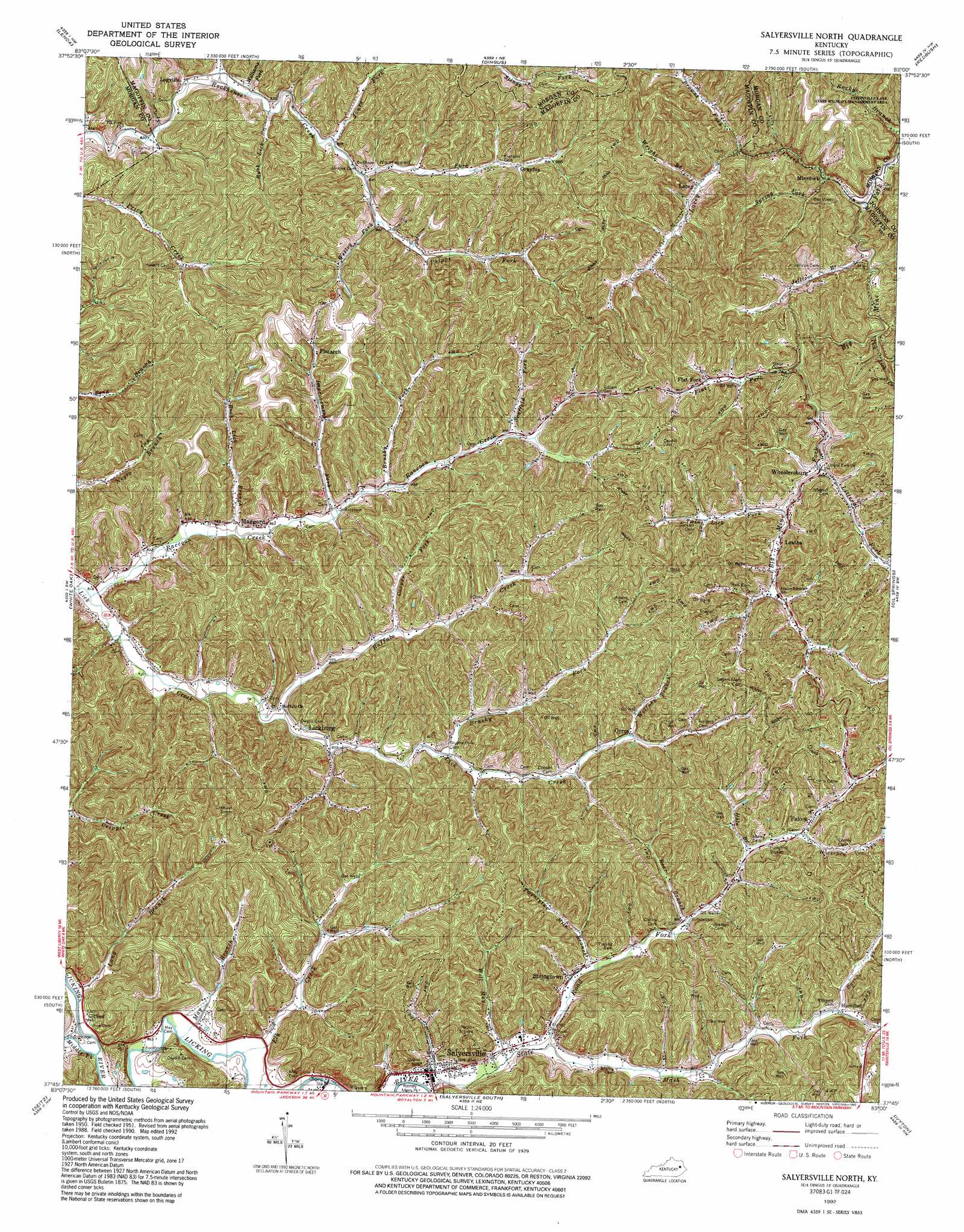
Salyersville North Topo Map Kentucky
To zoom in, hover over the map of Salyersville North
USGS Topo Quad 37083g1 - 1:24,000 scale
| Topo Map Name: | Salyersville North |
| USGS Topo Quad ID: | 37083g1 |
| Print Size: | ca. 21 1/4" wide x 27" high |
| Southeast Coordinates: | 37.75° N latitude / 83° W longitude |
| Map Center Coordinates: | 37.8125° N latitude / 83.0625° W longitude |
| U.S. State: | KY |
| Filename: | o37083g1.jpg |
| Download Map JPG Image: | Salyersville North topo map 1:24,000 scale |
| Map Type: | Topographic |
| Topo Series: | 7.5´ |
| Map Scale: | 1:24,000 |
| Source of Map Images: | United States Geological Survey (USGS) |
| Alternate Map Versions: |
Salyersville North KY 1951, updated 1953 Download PDF Buy paper map Salyersville North KY 1962, updated 1964 Download PDF Buy paper map Salyersville North KY 1962, updated 1976 Download PDF Buy paper map Salyersville North KY 1962, updated 1978 Download PDF Buy paper map Salyersville North KY 1992, updated 1992 Download PDF Buy paper map Salyersville North KY 2010 Download PDF Buy paper map Salyersville North KY 2013 Download PDF Buy paper map Salyersville North KY 2016 Download PDF Buy paper map |
1:24,000 Topo Quads surrounding Salyersville North
Wrigley |
Sandy Hook |
Isonville |
Mazie |
Blaine |
West Liberty |
Lenox |
Dingus |
Redbush |
Sitka |
Cannel City |
White Oak |
Salyersville North |
Oil Springs |
Paintsville |
Lee City |
Seitz |
Salyersville South |
Ivyton |
Prestonsburg |
Quicksand |
Guage |
Tiptop |
David |
Martin |
> Back to 37083e1 at 1:100,000 scale
> Back to 37082a1 at 1:250,000 scale
> Back to U.S. Topo Maps home
Salyersville North topo map: Gazetteer
Salyersville North: Parks
Ramey Memorial Park elevation 256m 839′Salyersville North: Populated Places
Cyrus elevation 290m 951′Ever elevation 313m 1026′
Falcon elevation 297m 974′
Flat Fork elevation 280m 918′
Gifford elevation 259m 849′
Grayfox elevation 284m 931′
Lacey elevation 256m 839′
Leatha elevation 278m 912′
Lickburg elevation 261m 856′
Logville elevation 252m 826′
Maggard elevation 261m 856′
Mashfork elevation 279m 915′
Minefork elevation 233m 764′
Plutarch elevation 309m 1013′
Salyersville elevation 260m 853′
Stringtown elevation 266m 872′
Wheelersburg elevation 260m 853′
Salyersville North: Post Offices
Emma Post Office (historical) elevation 294m 964′Guad Post Office (historical) elevation 280m 918′
Logville Post Office (historical) elevation 246m 807′
Mary Post Office (historical) elevation 278m 912′
Orient Post Office (historical) elevation 280m 918′
Perlie Post Office (historical) elevation 279m 915′
Salyersville Post Office (historical) elevation 262m 859′
Salyersville North: Streams
Bear Branch elevation 271m 889′Browns Fork elevation 242m 793′
Brushy Fork elevation 267m 875′
Brushy Fork elevation 262m 859′
Buck Lick Branch elevation 256m 839′
Buffalo Creek elevation 265m 869′
Burton Fork elevation 279m 915′
Coal Branch elevation 257m 843′
Cooper Fork elevation 266m 872′
Elk Creek elevation 255m 836′
Flat Fork elevation 246m 807′
Hammond Fork elevation 260m 853′
Horsepen Fork elevation 255m 836′
Improvement Fork elevation 276m 905′
Jones Fork elevation 260m 853′
Lacey Creek elevation 224m 734′
Litteral Fork elevation 266m 872′
Long Branch elevation 251m 823′
Mash Fork elevation 262m 859′
May Branch elevation 253m 830′
Middle Fork Licking River elevation 255m 836′
Raccoon Creek elevation 246m 807′
Rock Lick Branch elevation 255m 836′
Round Hole Branch elevation 277m 908′
Seaffold Fork elevation 273m 895′
Spring Fork elevation 232m 761′
State Road Fork elevation 286m 938′
Tick Lick Creek elevation 238m 780′
Twentytwo Mile Branch elevation 282m 925′
Twin Lick Fork elevation 265m 869′
Wesley Fork elevation 265m 869′
Will May Branch elevation 261m 856′
Williams Fork elevation 252m 826′
Wolfpen Branch elevation 291m 954′
Wright Branch elevation 255m 836′
Salyersville North digital topo map on disk
Buy this Salyersville North topo map showing relief, roads, GPS coordinates and other geographical features, as a high-resolution digital map file on DVD:
Western Virginia & Southern West Virginia
Buy digital topo maps: Western Virginia & Southern West Virginia