Cannel City Topo Map Kentucky
To zoom in, hover over the map of Cannel City
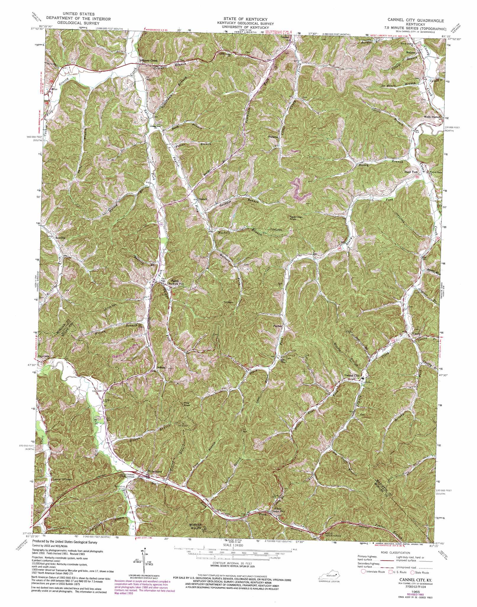
USGS Topo Quad 37083g3 - 1:24,000 scale
| Topo Map Name: | Cannel City |
| USGS Topo Quad ID: | 37083g3 |
| Print Size: | ca. 21 1/4" wide x 27" high |
| Southeast Coordinates: | 37.75° N latitude / 83.25° W longitude |
| Map Center Coordinates: | 37.8125° N latitude / 83.3125° W longitude |
| U.S. State: | KY |
| Filename: | o37083g3.jpg |
| Download Map JPG Image: | Cannel City topo map 1:24,000 scale |
| Map Type: | Topographic |
| Topo Series: | 7.5´ |
| Map Scale: | 1:24,000 |
| Source of Map Images: | United States Geological Survey (USGS) |
| Alternate Map Versions: |
Cannel City KY 1951, updated 1952 Download PDF Buy paper map Cannel City KY 1965, updated 1967 Download PDF Buy paper map Cannel City KY 1965, updated 1977 Download PDF Buy paper map Cannel City KY 1965, updated 1993 Download PDF Buy paper map Cannel City KY 2010 Download PDF Buy paper map Cannel City KY 2013 Download PDF Buy paper map Cannel City KY 2016 Download PDF Buy paper map |
1:24,000 Topo Quads surrounding Cannel City
Salt Lick |
Bangor |
Wrigley |
Sandy Hook |
Isonville |
Scranton |
Ezel |
West Liberty |
Lenox |
Dingus |
Pomeroyton |
Hazel Green |
Cannel City |
White Oak |
Salyersville North |
Campton |
Landsaw |
Lee City |
Seitz |
Salyersville South |
Tallega |
Jackson |
Quicksand |
Guage |
Tiptop |
> Back to 37083e1 at 1:100,000 scale
> Back to 37082a1 at 1:250,000 scale
> Back to U.S. Topo Maps home
Cannel City topo map: Gazetteer
Cannel City: Crossings
Adele Interchange elevation 331m 1085′Helechawa Interchange elevation 293m 961′
Cannel City: Flats
Saints Bottom elevation 264m 866′Cannel City: Populated Places
Adele elevation 308m 1010′Caney elevation 265m 869′
Cannel City elevation 272m 892′
Grassy Creek elevation 240m 787′
Head of Stacy Fork elevation 275m 902′
Helechawa elevation 305m 1000′
Lower Gillmore elevation 294m 964′
Malone elevation 243m 797′
Mize elevation 249m 816′
Nickell elevation 256m 839′
Panama elevation 277m 908′
Payton elevation 290m 951′
Rexville elevation 265m 869′
Right Fork elevation 248m 813′
Road Fork elevation 311m 1020′
Salem elevation 274m 898′
Sellars elevation 285m 935′
Stacy Fork elevation 251m 823′
Cannel City: Post Offices
Buskirk Post Office elevation 274m 898′Cannel City Post Office (historical) elevation 273m 895′
Demund Post Office (historical) elevation 253m 830′
Gilmore Post Office (historical) elevation 298m 977′
Grassy Creek Post Office (historical) elevation 238m 780′
Helechawa Post Office (historical) elevation 292m 958′
Insko Post Office elevation 308m 1010′
Insko Post Office (historical) elevation 308m 1010′
Lizzie Lane Post Office (historical) elevation 313m 1026′
Malone Post Office elevation 243m 797′
Mize Post Office (historical) elevation 249m 816′
Nickell Post Office (historical) elevation 256m 839′
Nickell Post Office (historical) elevation 244m 800′
Panama Post Office (historical) elevation 279m 915′
Payton Post Office (historical) elevation 288m 944′
Rexville Post Office (historical) elevation 266m 872′
Sellers Post Office (historical) elevation 285m 935′
Wells Post Office (historical) elevation 252m 826′
Cannel City: Streams
Arnett Branch elevation 297m 974′Barker Branch elevation 250m 820′
Benton Branch elevation 255m 836′
Big Staff Branch elevation 285m 935′
Brushy Fork elevation 260m 853′
Buck Branch elevation 241m 790′
Caskey Fork elevation 247m 810′
Castle Branch elevation 244m 800′
Conley Branch elevation 304m 997′
De Board Branch elevation 241m 790′
Doe Branch elevation 269m 882′
Eighth Branch elevation 291m 954′
Felins Branch elevation 243m 797′
Gevedon Branch elevation 255m 836′
Greear Branch elevation 237m 777′
Halsey Branch elevation 246m 807′
Haney Branch elevation 246m 807′
Lacy Branch elevation 290m 951′
Lewis Branch elevation 252m 826′
Lunce Branch elevation 290m 951′
Lykins Branch elevation 241m 790′
Mining Branch elevation 268m 879′
Nickell Branch elevation 260m 853′
Oldfield Fork elevation 247m 810′
Payton Fork elevation 240m 787′
Phils Branch elevation 242m 793′
Phipps Fork elevation 258m 846′
Poorhouse Fork elevation 243m 797′
Rosnick Branch elevation 256m 839′
Salem Fork elevation 237m 777′
Sellars Fork elevation 246m 807′
Spring Branch elevation 266m 872′
Stacy Fork elevation 247m 810′
State Road Fork elevation 287m 941′
Stick Branch elevation 291m 954′
Stinson Branch elevation 257m 843′
Stone Coal Fork elevation 272m 892′
Testerman Branch elevation 240m 787′
Village Branch elevation 239m 784′
Walters Fork elevation 267m 875′
Webb Branch elevation 250m 820′
Wilson Branch elevation 285m 935′
Wilson Branch elevation 269m 882′
Yearling Branch elevation 268m 879′
Cannel City: Summits
Pilot Knob elevation 403m 1322′Testerman Knob elevation 390m 1279′
Cannel City: Valleys
Gibbs Hollow elevation 297m 974′Cannel City digital topo map on disk
Buy this Cannel City topo map showing relief, roads, GPS coordinates and other geographical features, as a high-resolution digital map file on DVD:
Western Virginia & Southern West Virginia
Buy digital topo maps: Western Virginia & Southern West Virginia