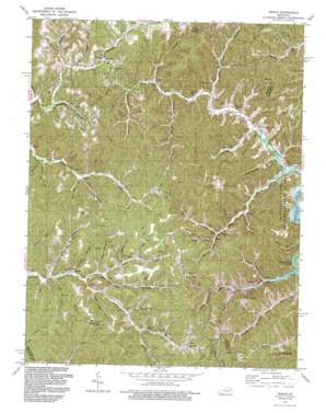
Dingus Topo Map Kentucky
To zoom in, hover over the map of Dingus
USGS Topo Quad 37083h1 - 1:24,000 scale
| Topo Map Name: | Dingus |
| USGS Topo Quad ID: | 37083h1 |
| Print Size: | ca. 21 1/4" wide x 27" high |
| Southeast Coordinates: | 37.875° N latitude / 83° W longitude |
| Map Center Coordinates: | 37.9375° N latitude / 83.0625° W longitude |
| U.S. State: | KY |
| Filename: | o37083h1.jpg |
| Download Map JPG Image: | Dingus topo map 1:24,000 scale |
| Map Type: | Topographic |
| Topo Series: | 7.5´ |
| Map Scale: | 1:24,000 |
| Source of Map Images: | United States Geological Survey (USGS) |
| Alternate Map Versions: |
Dingus KY 1951, updated 1953 Download PDF Buy paper map Dingus KY 1962, updated 1964 Download PDF Buy paper map Dingus KY 1962, updated 1976 Download PDF Buy paper map Dingus KY 1962, updated 1978 Download PDF Buy paper map Dingus KY 1962, updated 1988 Download PDF Buy paper map Dingus KY 1992, updated 1992 Download PDF Buy paper map Dingus KY 2010 Download PDF Buy paper map Dingus KY 2013 Download PDF Buy paper map Dingus KY 2016 Download PDF Buy paper map |
1:24,000 Topo Quads surrounding Dingus
> Back to 37083e1 at 1:100,000 scale
> Back to 37082a1 at 1:250,000 scale
> Back to U.S. Topo Maps home
Dingus topo map: Gazetteer
Dingus: Gaps
Peddler Gap elevation 255m 836′Dingus: Populated Places
Cindas Creek elevation 235m 770′Coffee Creek elevation 292m 958′
Crockett elevation 278m 912′
Dingus elevation 269m 882′
Jeptha elevation 262m 859′
Lost Creek elevation 262m 859′
Lower Sandlick elevation 241m 790′
Middle Fork elevation 254m 833′
Mima elevation 308m 1010′
Moon elevation 230m 754′
Ophir elevation 224m 734′
Silverhill elevation 316m 1036′
Upper Sandlick elevation 236m 774′
Dingus: Post Offices
Dingus Post Office (historical) elevation 267m 875′Fyffe Post Office (historical) elevation 252m 826′
Jeptha Post Office (historical) elevation 260m 853′
Mima Post Office (historical) elevation 246m 807′
Moon Post Office (historical) elevation 237m 777′
Ophir Post Office (historical) elevation 229m 751′
Relief Post Office (historical) elevation 227m 744′
Silverhill Post Office (historical) elevation 304m 997′
Dingus: Streams
Bear Branch elevation 252m 826′Birch Fork elevation 262m 859′
Buck Branch elevation 261m 856′
Cindas Creek elevation 222m 728′
Coffee Creek elevation 259m 849′
Deadling Branch elevation 256m 839′
Doc Ison Branch elevation 231m 757′
Ferguson Branch elevation 250m 820′
Fyffe Branch elevation 219m 718′
Gillam Branch elevation 259m 849′
Gray Branch elevation 283m 928′
Gum Bottom Branch elevation 234m 767′
Hinson Branch elevation 260m 853′
Hog Branch elevation 276m 905′
Horse Mill Branch elevation 258m 846′
Laurel Branch elevation 251m 823′
Laurel Fork elevation 250m 820′
Lick Branch elevation 253m 830′
Little Caney Branch elevation 244m 800′
Long Branch elevation 219m 718′
Meetinghouse Branch elevation 219m 718′
Old House Branch elevation 253m 830′
Old House Branch elevation 269m 882′
Pasture Branch elevation 240m 787′
Paulina Branch elevation 257m 843′
Pelfry Branch elevation 233m 764′
Peter Cave Branch elevation 259m 849′
Piney Branch elevation 254m 833′
Powder Spring Branch elevation 258m 846′
Right Fork Smith Creek elevation 251m 823′
Road Fork elevation 276m 905′
Smith Creek elevation 217m 711′
Sow Branch elevation 250m 820′
Splitwood Branch elevation 254m 833′
Stingy Fork elevation 273m 895′
Turpentine Branch elevation 233m 764′
White Oak Branch elevation 258m 846′
Willie Branch elevation 276m 905′
Dingus: Summits
Peddler Hill elevation 387m 1269′Dingus digital topo map on disk
Buy this Dingus topo map showing relief, roads, GPS coordinates and other geographical features, as a high-resolution digital map file on DVD:
Western Virginia & Southern West Virginia
Buy digital topo maps: Western Virginia & Southern West Virginia


