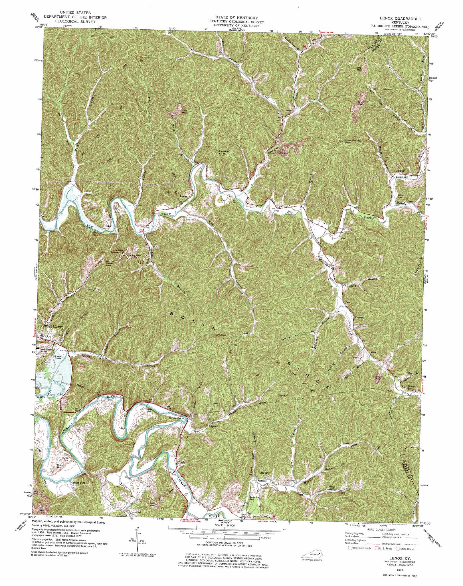
Lenox Topo Map Kentucky
To zoom in, hover over the map of Lenox
USGS Topo Quad 37083h2 - 1:24,000 scale
| Topo Map Name: | Lenox |
| USGS Topo Quad ID: | 37083h2 |
| Print Size: | ca. 21 1/4" wide x 27" high |
| Southeast Coordinates: | 37.875° N latitude / 83.125° W longitude |
| Map Center Coordinates: | 37.9375° N latitude / 83.1875° W longitude |
| U.S. State: | KY |
| Filename: | o37083h2.jpg |
| Download Map JPG Image: | Lenox topo map 1:24,000 scale |
| Map Type: | Topographic |
| Topo Series: | 7.5´ |
| Map Scale: | 1:24,000 |
| Source of Map Images: | United States Geological Survey (USGS) |
| Alternate Map Versions: |
Lenox KY 1950, updated 1953 Download PDF Buy paper map Lenox KY 1951, updated 1953 Download PDF Buy paper map Lenox KY 1951, updated 1973 Download PDF Buy paper map Lenox KY 1977, updated 1978 Download PDF Buy paper map Lenox KY 2010 Download PDF Buy paper map Lenox KY 2013 Download PDF Buy paper map Lenox KY 2016 Download PDF Buy paper map |
1:24,000 Topo Quads surrounding Lenox
Morehead |
Haldeman |
Ault |
Bruin |
Willard |
Bangor |
Wrigley |
Sandy Hook |
Isonville |
Mazie |
Ezel |
West Liberty |
Lenox |
Dingus |
Redbush |
Hazel Green |
Cannel City |
White Oak |
Salyersville North |
Oil Springs |
Landsaw |
Lee City |
Seitz |
Salyersville South |
Ivyton |
> Back to 37083e1 at 1:100,000 scale
> Back to 37082a1 at 1:250,000 scale
> Back to U.S. Topo Maps home
Lenox topo map: Gazetteer
Lenox: Bends
Cottle Bend elevation 241m 790′Lenox: Populated Places
Caskey Settement elevation 242m 793′Cottle elevation 244m 800′
Elamton elevation 254m 833′
Elkfork elevation 261m 856′
Florress elevation 249m 816′
Gordon Ford elevation 237m 777′
Jones Creek elevation 245m 803′
Lenox elevation 243m 797′
Rush Branch elevation 246m 807′
Lenox: Post Offices
Alice Post Office (historical) elevation 245m 803′Cattle Post Office (historical) elevation 243m 797′
Elamton Post Office (historical) elevation 256m 839′
Elamton Post Office (historical) elevation 255m 836′
Flores Post Office (historical) elevation 245m 803′
Forest Post Office (historical) elevation 252m 826′
Goodsey Post Office (historical) elevation 244m 800′
Gordon Ford Post Office (historical) elevation 231m 757′
Lennox Post Office (historical) elevation 243m 797′
Manker Post Office (historical) elevation 313m 1026′
Steele Post Office (historical) elevation 246m 807′
White Oak Post Office (historical) elevation 254m 833′
Lenox: Ridges
Bolin Ridge elevation 315m 1033′Lenox: Streams
Big Mandy Creek elevation 245m 803′Bolin Branch elevation 249m 816′
Conley Branch elevation 244m 800′
Cow Branch elevation 237m 777′
Dunnie Branch elevation 255m 836′
Fannins Fork elevation 250m 820′
Ferguson Branch elevation 247m 810′
Grampus Branch elevation 249m 816′
Harper Branch elevation 241m 790′
Indian Creek elevation 233m 764′
Jones Creek elevation 231m 757′
Left Fork Lacy Creek elevation 247m 810′
Left Fork Laurel Fork elevation 255m 836′
Lick Branch elevation 237m 777′
Middle Fork Elk Fork elevation 246m 807′
Middle Fork Lacy Creek elevation 247m 810′
Mill Branch elevation 238m 780′
Mill Branch elevation 236m 774′
Mordica Branch elevation 232m 761′
Muddy Branch elevation 250m 820′
Pelfrey Branch elevation 245m 803′
Right Fork Lacy Creek elevation 247m 810′
Right Fork Laurel Fork elevation 255m 836′
Rockhouse Branch elevation 262m 859′
Rush Branch elevation 238m 780′
Simpson Branch elevation 249m 816′
Spaws Creek elevation 236m 774′
Stable Branch elevation 238m 780′
Straight Creek elevation 238m 780′
Sugar Camp Branch elevation 243m 797′
Tantroft Branch elevation 248m 813′
War Creek elevation 232m 761′
White Oak Creek elevation 238m 780′
Williams Creek elevation 244m 800′
Lenox: Summits
Fairfield Hill elevation 287m 941′Granddaddy Knob elevation 385m 1263′
Limekiln Knob elevation 376m 1233′
Park Hill elevation 257m 843′
Lenox digital topo map on disk
Buy this Lenox topo map showing relief, roads, GPS coordinates and other geographical features, as a high-resolution digital map file on DVD:
Western Virginia & Southern West Virginia
Buy digital topo maps: Western Virginia & Southern West Virginia