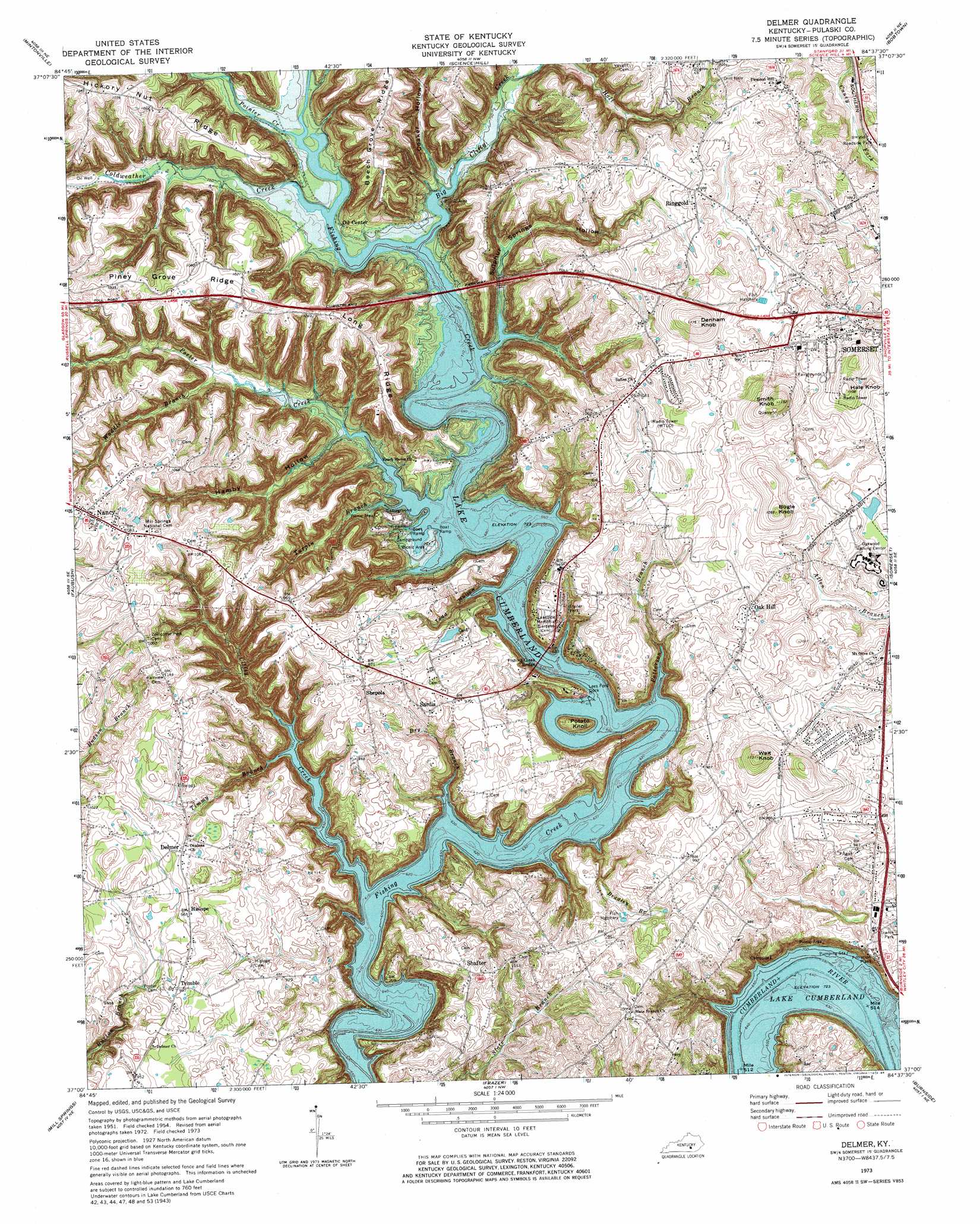
Delmer Topo Map Kentucky
To zoom in, hover over the map of Delmer
USGS Topo Quad 37084a6 - 1:24,000 scale
| Topo Map Name: | Delmer |
| USGS Topo Quad ID: | 37084a6 |
| Print Size: | ca. 21 1/4" wide x 27" high |
| Southeast Coordinates: | 37° N latitude / 84.625° W longitude |
| Map Center Coordinates: | 37.0625° N latitude / 84.6875° W longitude |
| U.S. State: | KY |
| Filename: | o37084a6.jpg |
| Download Map JPG Image: | Delmer topo map 1:24,000 scale |
| Map Type: | Topographic |
| Topo Series: | 7.5´ |
| Map Scale: | 1:24,000 |
| Source of Map Images: | United States Geological Survey (USGS) |
| Alternate Map Versions: |
Delmer KY 1954, updated 1955 Download PDF Buy paper map Delmer KY 1961, updated 1962 Download PDF Buy paper map Delmer KY 1973, updated 1974 Download PDF Buy paper map Delmer KY 1973, updated 1984 Download PDF Buy paper map Delmer KY 2010 Download PDF Buy paper map Delmer KY 2013 Download PDF Buy paper map Delmer KY 2016 Download PDF Buy paper map |
1:24,000 Topo Quads surrounding Delmer
Liberty |
Yosemite |
Eubank |
Woodstock |
Maretburg |
Phil |
Mintonville |
Science Hill |
Bobtown |
Shopville |
Eli |
Faubush |
Delmer |
Somerset |
Dykes |
Jabez |
Mill Springs |
Frazer |
Burnside |
Hail |
Parnell |
Monticello |
Coopersville |
Nevelsville |
Wiborg |
> Back to 37084a1 at 1:100,000 scale
> Back to 37084a1 at 1:250,000 scale
> Back to U.S. Topo Maps home
Delmer topo map: Gazetteer
Delmer: Airports
Somerset-Pulaski County EMS Heliport elevation 311m 1020′Delmer: Bridges
Fishing Creek Bridge elevation 220m 721′Delmer: Populated Places
Delmer elevation 298m 977′Hislope elevation 294m 964′
Nancy elevation 327m 1072′
Oak Hill elevation 304m 997′
Oil Center elevation 236m 774′
Ringgold elevation 331m 1085′
Sardis elevation 292m 958′
Shafter elevation 297m 974′
Shepola elevation 300m 984′
Trimble elevation 290m 951′
Delmer: Ridges
Hickory Nut Ridge elevation 314m 1030′Long Ridge elevation 308m 1010′
Piney Grove Ridge elevation 324m 1062′
Delmer: Streams
Big Clifty Creek elevation 220m 721′Brandley Branch elevation 274m 898′
Clifty Creek elevation 220m 721′
Coldweather Creek elevation 220m 721′
Dry Branch elevation 220m 721′
Patterson Branch elevation 220m 721′
Pointer Creek elevation 220m 721′
Porter Creek elevation 220m 721′
Timmy Branch elevation 220m 721′
Turpin Branch elevation 220m 721′
Waddle Branch elevation 234m 767′
Delmer: Summits
Bogle Knob elevation 329m 1079′Denham Knob elevation 353m 1158′
Hale Knob elevation 337m 1105′
Potato Knoll elevation 256m 839′
Smith Knob elevation 351m 1151′
Wait Knob elevation 344m 1128′
Delmer: Valleys
Coaker Hollow elevation 229m 751′Hamby Hollow elevation 229m 751′
Sulphur Springs Hollow elevation 221m 725′
Todd Hollow elevation 220m 721′
Delmer digital topo map on disk
Buy this Delmer topo map showing relief, roads, GPS coordinates and other geographical features, as a high-resolution digital map file on DVD: