Bernstadt Topo Map Kentucky
To zoom in, hover over the map of Bernstadt
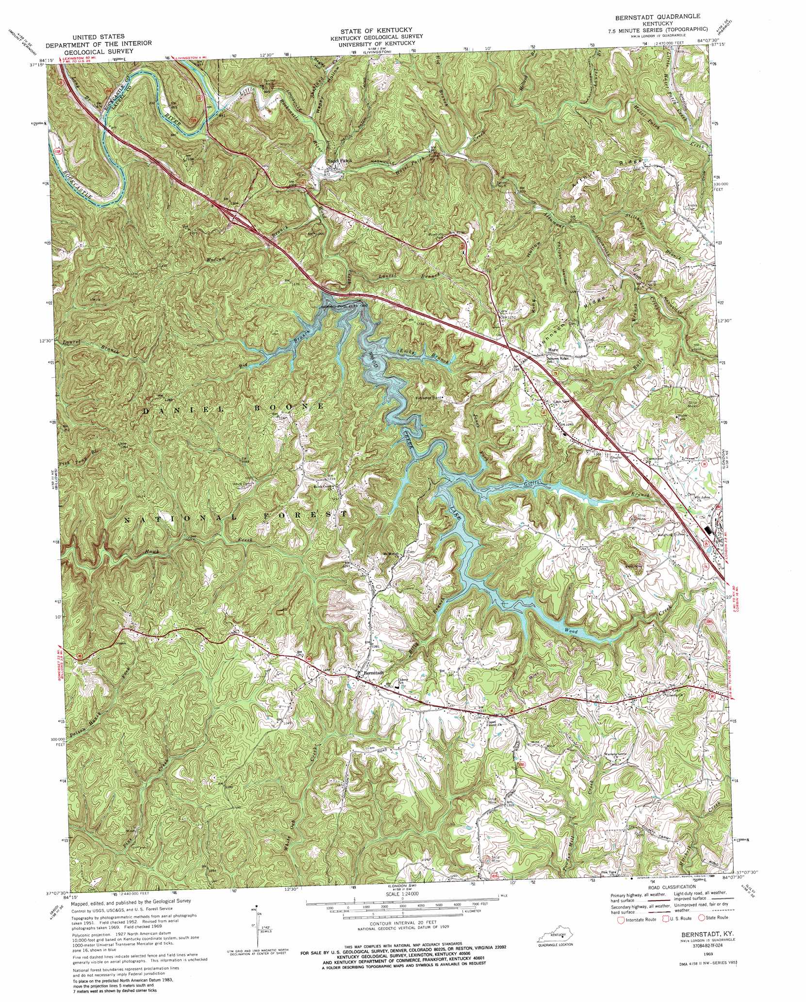
USGS Topo Quad 37084b2 - 1:24,000 scale
| Topo Map Name: | Bernstadt |
| USGS Topo Quad ID: | 37084b2 |
| Print Size: | ca. 21 1/4" wide x 27" high |
| Southeast Coordinates: | 37.125° N latitude / 84.125° W longitude |
| Map Center Coordinates: | 37.1875° N latitude / 84.1875° W longitude |
| U.S. State: | KY |
| Filename: | o37084b2.jpg |
| Download Map JPG Image: | Bernstadt topo map 1:24,000 scale |
| Map Type: | Topographic |
| Topo Series: | 7.5´ |
| Map Scale: | 1:24,000 |
| Source of Map Images: | United States Geological Survey (USGS) |
| Alternate Map Versions: |
Bernstadt KY 1952, updated 1954 Download PDF Buy paper map Bernstadt KY 1952, updated 1969 Download PDF Buy paper map Bernstadt KY 1969, updated 1971 Download PDF Buy paper map Bernstadt KY 1969, updated 1977 Download PDF Buy paper map Bernstadt KY 1969, updated 1989 Download PDF Buy paper map Bernstadt KY 2010 Download PDF Buy paper map Bernstadt KY 2013 Download PDF Buy paper map Bernstadt KY 2016 Download PDF Buy paper map |
| FStopo: | US Forest Service topo Bernstadt is available: Download FStopo PDF Download FStopo TIF |
1:24,000 Topo Quads surrounding Bernstadt
Brodhead |
Wildie |
Johnetta |
Sandgap |
Mckee |
Maretburg |
Mount Vernon |
Livingston |
Parrot |
Tyner |
Shopville |
Billows |
Bernstadt |
London |
Portersburg |
Dykes |
Ano |
London Sw |
Lily |
Blackwater |
Hail |
Sawyer |
Vox |
Corbin |
Heidrick |
> Back to 37084a1 at 1:100,000 scale
> Back to 37084a1 at 1:250,000 scale
> Back to U.S. Topo Maps home
Bernstadt topo map: Gazetteer
Bernstadt: Airports
GG Heliport elevation 353m 1158′Bernstadt: Populated Places
Bernstadt elevation 390m 1279′Hare elevation 381m 1250′
Hazel Patch elevation 352m 1154′
Bernstadt: Reservoirs
Wood Creek Lake elevation 306m 1003′Bernstadt: Ridges
Arthur Ridge elevation 347m 1138′Johnson Ridge elevation 371m 1217′
Bernstadt: Streams
Altamont Creek elevation 267m 875′Big Branch elevation 306m 1003′
Billy Branch elevation 306m 1003′
Bulls Branch elevation 298m 977′
Gillis Branch elevation 306m 1003′
Hazel Patch Creek elevation 264m 866′
Hellard Branch elevation 274m 898′
Hog Branch elevation 289m 948′
Jones Fork elevation 306m 1003′
Laurel Branch elevation 294m 964′
Laurel Branch elevation 266m 872′
Little Hazel Patch Creek elevation 305m 1000′
Little Rockcastle River elevation 255m 836′
Long Branch elevation 253m 830′
Rocky Branch elevation 306m 1003′
Shetland Creek elevation 258m 846′
Stillhouse Branch elevation 292m 958′
Wollum Branch elevation 259m 849′
Wood Creek elevation 262m 859′
Bernstadt: Tunnels
Tunnel Number 6 elevation 306m 1003′Tunnel Number 7 elevation 312m 1023′
Tunnel Number 8 elevation 319m 1046′
Tunnel Number 9 elevation 349m 1145′
Bernstadt: Valleys
Begley Hollow elevation 266m 872′Happy Hollow elevation 262m 859′
King Hollow elevation 286m 938′
Milburn Hollow elevation 266m 872′
Philpot Hollow elevation 298m 977′
Bernstadt digital topo map on disk
Buy this Bernstadt topo map showing relief, roads, GPS coordinates and other geographical features, as a high-resolution digital map file on DVD: