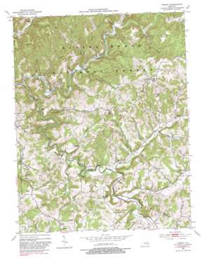
Parrot Topo Map Kentucky
To zoom in, hover over the map of Parrot
USGS Topo Quad 37084c1 - 1:24,000 scale
| Topo Map Name: | Parrot |
| USGS Topo Quad ID: | 37084c1 |
| Print Size: | ca. 21 1/4" wide x 27" high |
| Southeast Coordinates: | 37.25° N latitude / 84° W longitude |
| Map Center Coordinates: | 37.3125° N latitude / 84.0625° W longitude |
| U.S. State: | KY |
| Filename: | o37084c1.jpg |
| Download Map JPG Image: | Parrot topo map 1:24,000 scale |
| Map Type: | Topographic |
| Topo Series: | 7.5´ |
| Map Scale: | 1:24,000 |
| Source of Map Images: | United States Geological Survey (USGS) |
| Alternate Map Versions: |
Parrot KY 1953, updated 1955 Download PDF Buy paper map Parrot KY 1953, updated 1968 Download PDF Buy paper map Parrot KY 1953, updated 1981 Download PDF Buy paper map Parrot KY 2010 Download PDF Buy paper map Parrot KY 2013 Download PDF Buy paper map Parrot KY 2016 Download PDF Buy paper map |
| FStopo: | US Forest Service topo Parrot is available: Download FStopo PDF Download FStopo TIF |
1:24,000 Topo Quads surrounding Parrot
> Back to 37084a1 at 1:100,000 scale
> Back to 37084a1 at 1:250,000 scale
> Back to U.S. Topo Maps home
Parrot topo map: Gazetteer
Parrot: Populated Places
Ardery elevation 285m 935′Cornelius elevation 305m 1000′
Cornette elevation 306m 1003′
Cruise elevation 378m 1240′
Dabolt elevation 392m 1286′
Dango elevation 284m 931′
Eberle elevation 315m 1033′
Flatton elevation 386m 1266′
Lantana elevation 284m 931′
Laurel Branch elevation 309m 1013′
Old Bend elevation 357m 1171′
Peoples elevation 296m 971′
Pine Flat elevation 410m 1345′
Seven Pines elevation 411m 1348′
Victory elevation 361m 1184′
Parrot: Post Offices
Ardery Post Office (historical) elevation 279m 915′Carko Post Office (historical) elevation 298m 977′
Cornelius Post Office (historical) elevation 308m 1010′
Dango Post Office (historical) elevation 284m 931′
Debolt Post Office (historical) elevation 410m 1345′
Deese Post Office (historical) elevation 405m 1328′
Eberele Post Office (historical) elevation 306m 1003′
Lantana Post Office (historical) elevation 284m 931′
Middle Fork Post Office (historical) elevation 278m 912′
Parrot Post Office (historical) elevation 393m 1289′
Peoples Post Office (historical) elevation 297m 974′
Parrot: Streams
Alum Cave Branch elevation 295m 967′Black Lick Branch elevation 280m 918′
Buzzard Branch elevation 292m 958′
Cave Branch elevation 286m 938′
Dry Branch elevation 292m 958′
Hog Branch elevation 282m 925′
Indian Creek elevation 284m 931′
Laurel Branch elevation 280m 918′
Laurel Fork elevation 284m 931′
MacKanaw Creek elevation 277m 908′
Middle Fork Rockcastle River elevation 266m 872′
Moores Creek elevation 292m 958′
Nichols Branch elevation 298m 977′
Panther Creek elevation 280m 918′
Peter Branch elevation 270m 885′
Peter Cave Branch elevation 278m 912′
Pigeon Roost Branch elevation 299m 980′
Pond Creek elevation 285m 935′
Pond Lick Branch elevation 303m 994′
Raccoon Creek elevation 286m 938′
Renfro Branch elevation 277m 908′
Robinson Creek elevation 270m 885′
Saruis Branch elevation 280m 918′
Seals Branch elevation 319m 1046′
South Fork Rockcastle River elevation 266m 872′
Stanberry Branch elevation 298m 977′
Toms Branch elevation 297m 974′
White Oak Creek elevation 283m 928′
Wolf Pen Branch elevation 288m 944′
Parrot digital topo map on disk
Buy this Parrot topo map showing relief, roads, GPS coordinates and other geographical features, as a high-resolution digital map file on DVD:


