Livingston Topo Map Kentucky
To zoom in, hover over the map of Livingston
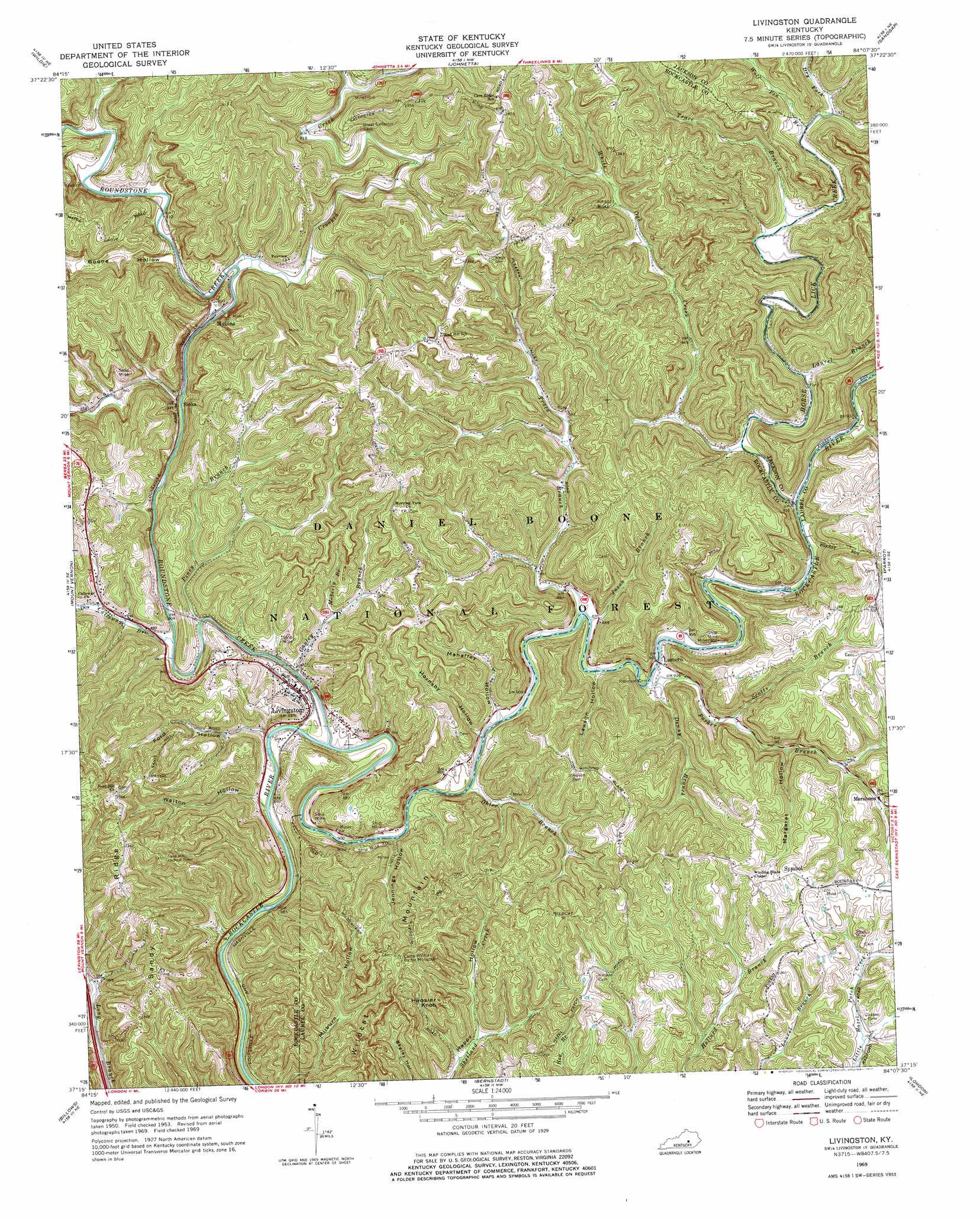
USGS Topo Quad 37084c2 - 1:24,000 scale
| Topo Map Name: | Livingston |
| USGS Topo Quad ID: | 37084c2 |
| Print Size: | ca. 21 1/4" wide x 27" high |
| Southeast Coordinates: | 37.25° N latitude / 84.125° W longitude |
| Map Center Coordinates: | 37.3125° N latitude / 84.1875° W longitude |
| U.S. State: | KY |
| Filename: | o37084c2.jpg |
| Download Map JPG Image: | Livingston topo map 1:24,000 scale |
| Map Type: | Topographic |
| Topo Series: | 7.5´ |
| Map Scale: | 1:24,000 |
| Source of Map Images: | United States Geological Survey (USGS) |
| Alternate Map Versions: |
Livingston KY 1953, updated 1954 Download PDF Buy paper map Livingston KY 1953, updated 1969 Download PDF Buy paper map Livingston KY 1969, updated 1971 Download PDF Buy paper map Livingston KY 1969, updated 1977 Download PDF Buy paper map Livingston KY 2010 Download PDF Buy paper map Livingston KY 2013 Download PDF Buy paper map Livingston KY 2016 Download PDF Buy paper map |
| FStopo: | US Forest Service topo Livingston is available: Download FStopo PDF Download FStopo TIF |
1:24,000 Topo Quads surrounding Livingston
Paint Lick |
Berea |
Bighill |
Alcorn |
Leighton |
Brodhead |
Wildie |
Johnetta |
Sandgap |
Mckee |
Maretburg |
Mount Vernon |
Livingston |
Parrot |
Tyner |
Shopville |
Billows |
Bernstadt |
London |
Portersburg |
Dykes |
Ano |
London Sw |
Lily |
Blackwater |
> Back to 37084a1 at 1:100,000 scale
> Back to 37084a1 at 1:250,000 scale
> Back to U.S. Topo Maps home
Livingston topo map: Gazetteer
Livingston: Crossings
Cruise Ferry elevation 275m 902′Livingston: Parks
Camp Wildcat Battle Monument elevation 386m 1266′Livingston: Populated Places
Lamero elevation 273m 895′Livingston elevation 278m 912′
Mershons elevation 331m 1085′
Mullins elevation 268m 879′
Sinks elevation 295m 967′
Symbol elevation 382m 1253′
Livingston: Post Offices
Lamero Post Office elevation 272m 892′Livingston: Ridges
Sandy Ridge elevation 414m 1358′Livingston: Streams
Calloway Branch elevation 260m 853′Crooked Creek elevation 268m 879′
Denny Branch elevation 267m 875′
Dry Fork elevation 281m 921′
Gauley Branch elevation 262m 859′
Horse Lick Creek elevation 266m 872′
Jason Branch elevation 268m 879′
Laurel Branch elevation 276m 905′
Moberly Branch elevation 282m 925′
Ohler Branch elevation 264m 866′
Parker Branch elevation 268m 879′
Piney Branch elevation 265m 869′
Roundstone Creek elevation 259m 849′
Scotts Branch elevation 283m 928′
Trace Branch elevation 267m 875′
Trace Branch elevation 279m 915′
White Oak Creek elevation 268m 879′
Wolf Pen Branch elevation 280m 918′
Livingston: Summits
Hoosier Knob elevation 407m 1335′Wildcat Mountain elevation 417m 1368′
Livingston: Valleys
Boone Hollow elevation 277m 908′Ford Hollow elevation 266m 872′
Hornsby Hollow elevation 263m 862′
Jennings Hollow elevation 264m 866′
Lawson Hollow elevation 268m 879′
Mahaffey Hollow elevation 267m 875′
Margaret Hollow elevation 306m 1003′
Walton Hollow elevation 267m 875′
Livingston digital topo map on disk
Buy this Livingston topo map showing relief, roads, GPS coordinates and other geographical features, as a high-resolution digital map file on DVD: