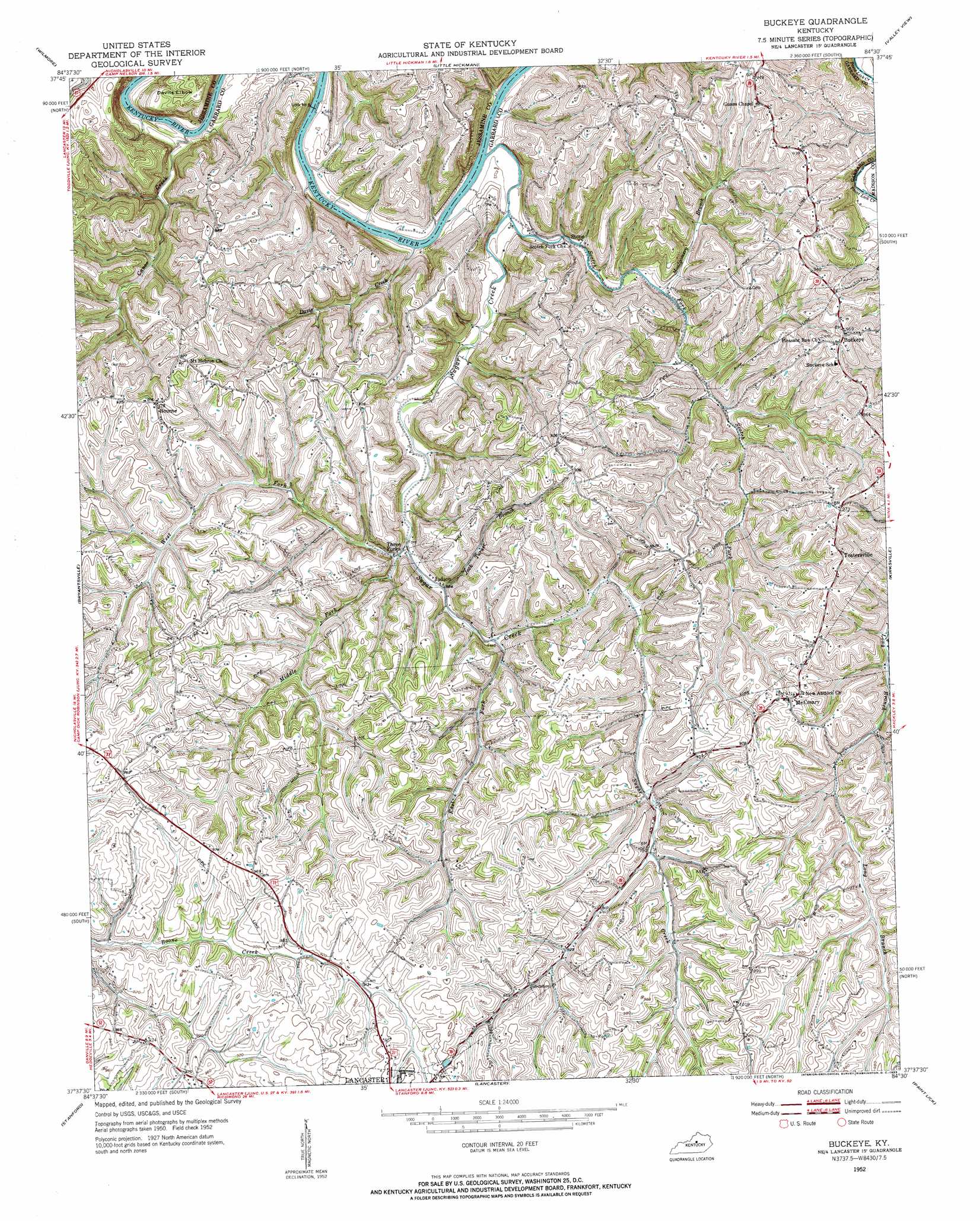
Buckeye Topo Map Kentucky
To zoom in, hover over the map of Buckeye
USGS Topo Quad 37084f5 - 1:24,000 scale
| Topo Map Name: | Buckeye |
| USGS Topo Quad ID: | 37084f5 |
| Print Size: | ca. 21 1/4" wide x 27" high |
| Southeast Coordinates: | 37.625° N latitude / 84.5° W longitude |
| Map Center Coordinates: | 37.6875° N latitude / 84.5625° W longitude |
| U.S. State: | KY |
| Filename: | o37084f5.jpg |
| Download Map JPG Image: | Buckeye topo map 1:24,000 scale |
| Map Type: | Topographic |
| Topo Series: | 7.5´ |
| Map Scale: | 1:24,000 |
| Source of Map Images: | United States Geological Survey (USGS) |
| Alternate Map Versions: |
Buckeye KY 1952, updated 1953 Download PDF Buy paper map Buckeye KY 2010 Download PDF Buy paper map Buckeye KY 2013 Download PDF Buy paper map Buckeye KY 2016 Download PDF Buy paper map |
1:24,000 Topo Quads surrounding Buckeye
Salvisa |
Keene |
Nicholasville |
Coletown |
Ford |
Harrodsburg |
Wilmore |
Little Hickman |
Valley View |
Richmond North |
Danville |
Bryantsville |
Buckeye |
Kirksville |
Richmond South |
Junction City |
Stanford |
Lancaster |
Paint Lick |
Berea |
Hustonville |
Halls Gap |
Crab Orchard |
Brodhead |
Wildie |
> Back to 37084e1 at 1:100,000 scale
> Back to 37084a1 at 1:250,000 scale
> Back to U.S. Topo Maps home
Buckeye topo map: Gazetteer
Buckeye: Bends
Devils Elbow elevation 234m 767′Buckeye: Crossings
Sugar Creek Ferry (historical) elevation 165m 541′Buckeye: Dams
United States Lock Number Eight elevation 160m 524′United States Lock Number Eight Kentucky River elevation 162m 531′
Buckeye: Populated Places
Bourne elevation 283m 928′Buckeye elevation 291m 954′
Guy (historical) elevation 235m 770′
Judson elevation 203m 666′
McCreary elevation 296m 971′
Stone elevation 177m 580′
Sweet Home (historical) elevation 177m 580′
Teatersville elevation 290m 951′
Three Forks elevation 196m 643′
Buckeye: Post Offices
Bettice Post Office (historical) elevation 299m 980′Bourne Post Office (historical) elevation 279m 915′
Buckeye Post Office (historical) elevation 291m 954′
Coy Post Office (historical) elevation 165m 541′
Edinboro Post Office (historical) elevation 168m 551′
Hogback Post Office (historical) elevation 199m 652′
Judson Post Office (historical) elevation 204m 669′
Lloyd Post Office (historical) elevation 282m 925′
McCreary Post Office (historical) elevation 299m 980′
Stone Post Office (historical) elevation 166m 544′
Teatersville Post Office (historical) elevation 294m 964′
Buckeye: Ridges
Leavell Ridge elevation 227m 744′Buckeye: Streams
Canoe Creek elevation 159m 521′Davis Creek elevation 170m 557′
East Fork Sugar Creek elevation 208m 682′
Jack Turner Branch elevation 201m 659′
Middle Fork Sugar Creek elevation 199m 652′
Montgomery Branch elevation 193m 633′
Scotch Fork elevation 166m 544′
Sugar Creek elevation 165m 541′
West Fork Sugar Creek elevation 195m 639′
Buckeye digital topo map on disk
Buy this Buckeye topo map showing relief, roads, GPS coordinates and other geographical features, as a high-resolution digital map file on DVD: