Little Hickman Topo Map Kentucky
To zoom in, hover over the map of Little Hickman
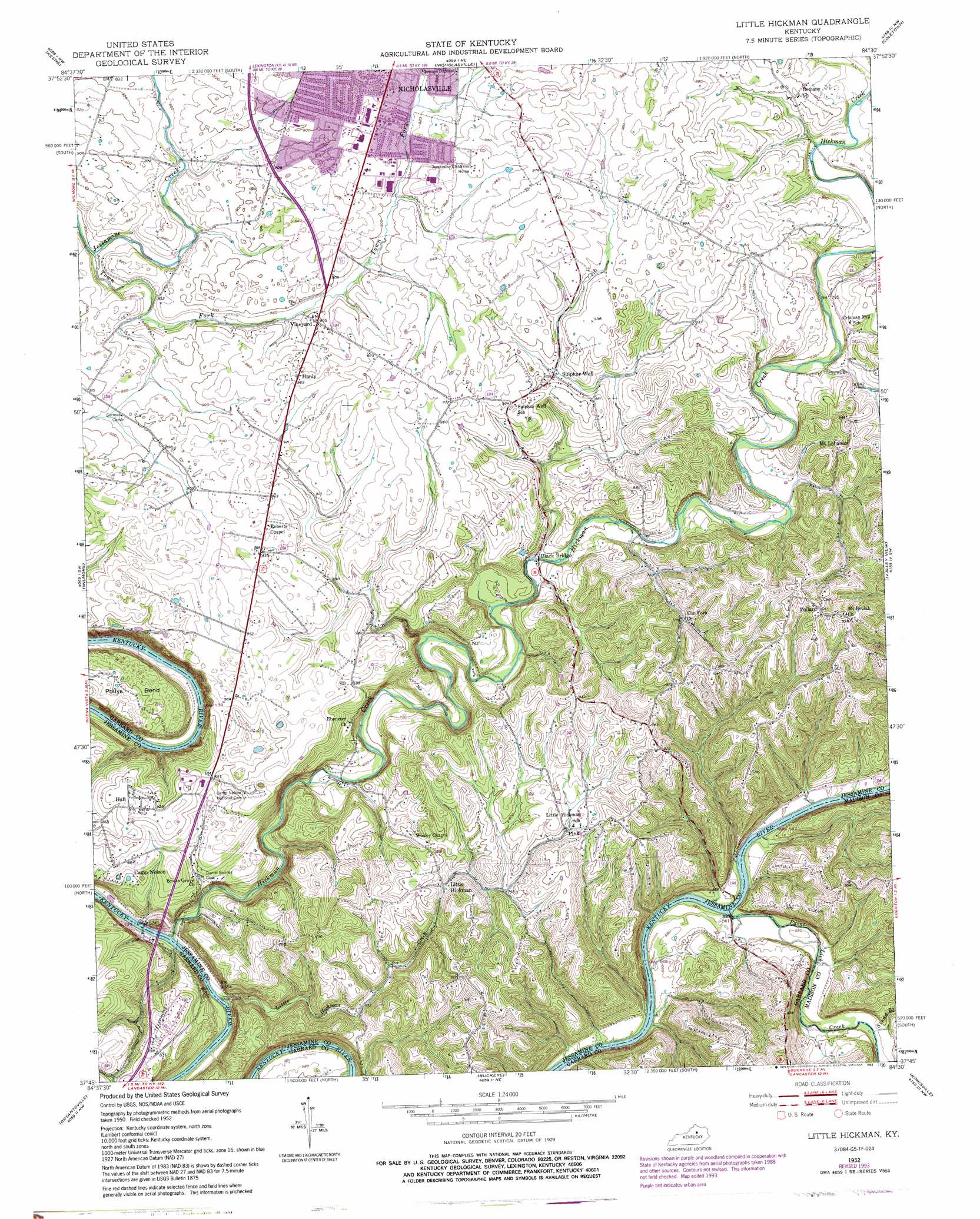
USGS Topo Quad 37084g5 - 1:24,000 scale
| Topo Map Name: | Little Hickman |
| USGS Topo Quad ID: | 37084g5 |
| Print Size: | ca. 21 1/4" wide x 27" high |
| Southeast Coordinates: | 37.75° N latitude / 84.5° W longitude |
| Map Center Coordinates: | 37.8125° N latitude / 84.5625° W longitude |
| U.S. State: | KY |
| Filename: | o37084g5.jpg |
| Download Map JPG Image: | Little Hickman topo map 1:24,000 scale |
| Map Type: | Topographic |
| Topo Series: | 7.5´ |
| Map Scale: | 1:24,000 |
| Source of Map Images: | United States Geological Survey (USGS) |
| Alternate Map Versions: |
Little Hickman KY 1952, updated 1953 Download PDF Buy paper map Little Hickman KY 1952, updated 1966 Download PDF Buy paper map Little Hickman KY 1952, updated 1976 Download PDF Buy paper map Little Hickman KY 1952, updated 1979 Download PDF Buy paper map Little Hickman KY 1952, updated 1988 Download PDF Buy paper map Little Hickman KY 1952, updated 1993 Download PDF Buy paper map Little Hickman KY 2010 Download PDF Buy paper map Little Hickman KY 2013 Download PDF Buy paper map Little Hickman KY 2016 Download PDF Buy paper map |
1:24,000 Topo Quads surrounding Little Hickman
Tyrone |
Versailles |
Lexington West |
Lexington East |
Clintonville |
Salvisa |
Keene |
Nicholasville |
Coletown |
Ford |
Harrodsburg |
Wilmore |
Little Hickman |
Valley View |
Richmond North |
Danville |
Bryantsville |
Buckeye |
Kirksville |
Richmond South |
Junction City |
Stanford |
Lancaster |
Paint Lick |
Berea |
> Back to 37084e1 at 1:100,000 scale
> Back to 37084a1 at 1:250,000 scale
> Back to U.S. Topo Maps home
Little Hickman topo map: Gazetteer
Little Hickman: Bridges
Black Bridge elevation 207m 679′Camp Nelson Bridge (historical) elevation 159m 521′
Little Hickman: Crossings
Hogans Ferry (historical) elevation 162m 531′Paint Lick Ferry (historical) elevation 164m 538′
Little Hickman: Flats
The Territory elevation 176m 577′Little Hickman: Populated Places
Camp Nelson (historical) elevation 165m 541′Chattersville (historical) elevation 252m 826′
Crisman Mill (historical) elevation 262m 859′
Edgewood (historical) elevation 293m 961′
Hall elevation 287m 941′
Hanly elevation 293m 961′
Little Hickman elevation 224m 734′
Mount Lebanon elevation 292m 958′
Oak Hill (historical) elevation 172m 564′
Pink elevation 242m 793′
Pollard elevation 305m 1000′
Sulphur Well Park (historical) elevation 286m 938′
Vineyard elevation 276m 905′
Watts Store (historical) elevation 220m 721′
Little Hickman: Post Offices
Ambrose Post Office (historical) elevation 258m 846′Boons Knob Post Office (historical) elevation 183m 600′
Brumfield Post Office (historical) elevation 167m 547′
Camp Nelson Post Office (historical) elevation 184m 603′
Fitchport Post Office (historical) elevation 166m 544′
Giles Post Office (historical) elevation 187m 613′
Hanly Post Office (historical) elevation 288m 944′
Little Hickman Post Office (historical) elevation 217m 711′
Mount Lebanon Post Office (historical) elevation 288m 944′
Pink Post Office (historical) elevation 250m 820′
Potts Mill Post Office (historical) elevation 187m 613′
Saunders Ferry Post Office (historical) elevation 169m 554′
Little Hickman: Streams
Elm Fork elevation 212m 695′Hickman Creek elevation 156m 511′
Lick Branch elevation 162m 531′
Little Hickman Creek elevation 157m 515′
Paint Lick Creek elevation 165m 541′
Sledd Branch elevation 174m 570′
Town Fork elevation 242m 793′
Little Hickman: Summits
Boones Knob elevation 223m 731′Chimney Rock elevation 256m 839′
Little Hickman: Woods
White Oak Woods elevation 243m 797′Little Hickman digital topo map on disk
Buy this Little Hickman topo map showing relief, roads, GPS coordinates and other geographical features, as a high-resolution digital map file on DVD: