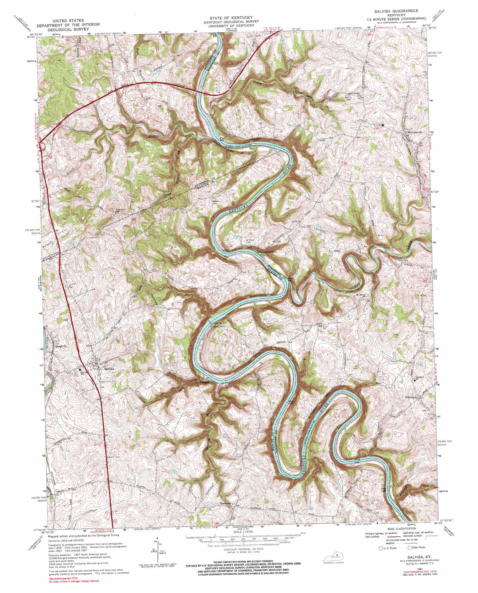
Salvisa Topo Map Kentucky
To zoom in, hover over the map of Salvisa
USGS Topo Quad 37084h7 - 1:24,000 scale
| Topo Map Name: | Salvisa |
| USGS Topo Quad ID: | 37084h7 |
| Print Size: | ca. 21 1/4" wide x 27" high |
| Southeast Coordinates: | 37.875° N latitude / 84.75° W longitude |
| Map Center Coordinates: | 37.9375° N latitude / 84.8125° W longitude |
| U.S. State: | KY |
| Filename: | o37084h7.jpg |
| Download Map JPG Image: | Salvisa topo map 1:24,000 scale |
| Map Type: | Topographic |
| Topo Series: | 7.5´ |
| Map Scale: | 1:24,000 |
| Source of Map Images: | United States Geological Survey (USGS) |
| Alternate Map Versions: |
Salvisa KY 1952, updated 1953 Download PDF Buy paper map Salvisa KY 1967, updated 1969 Download PDF Buy paper map Salvisa KY 1967, updated 1984 Download PDF Buy paper map Salvisa KY 2010 Download PDF Buy paper map Salvisa KY 2013 Download PDF Buy paper map Salvisa KY 2016 Download PDF Buy paper map |
1:24,000 Topo Quads surrounding Salvisa
Waddy |
Frankfort West |
Frankfort East |
Midway |
Georgetown |
Glensboro |
Lawrenceburg |
Tyrone |
Versailles |
Lexington West |
Ashbrook |
Mcbrayer |
Salvisa |
Keene |
Nicholasville |
Cardwell |
Cornishville |
Harrodsburg |
Wilmore |
Little Hickman |
Mackville |
Perryville |
Danville |
Bryantsville |
Buckeye |
> Back to 37084e1 at 1:100,000 scale
> Back to 37084a1 at 1:250,000 scale
> Back to U.S. Topo Maps home
Salvisa topo map: Gazetteer
Salvisa: Bends
Chapman Bend elevation 165m 541′Oregon Bend elevation 160m 524′
Salvisa: Crossings
Cummins Ferry (historical) elevation 150m 492′Scotts Ferry (historical) elevation 155m 508′
Warwick Ferry (historical) elevation 151m 495′
Salvisa: Dams
Lock Number 6 elevation 149m 488′Salvisa: Populated Places
Bondville elevation 238m 780′Cummins Ferry (historical) elevation 261m 856′
Ebenezer elevation 252m 826′
Houchin (historical) elevation 257m 843′
Mortonsville elevation 246m 807′
Nonesuch elevation 249m 816′
Oregon elevation 159m 521′
Salvisa elevation 246m 807′
Salvisa: Post Offices
Bondville Post Office (historical) elevation 240m 787′Ebenezer Post Office (historical) elevation 243m 797′
Mortonsville Post Office (historical) elevation 244m 800′
Nonesuch Post Office (historical) elevation 245m 803′
Warwick Post Office (historical) elevation 194m 636′
Salvisa: Springs
Lillards Spring elevation 220m 721′Salvisa: Streams
Brushy Run elevation 152m 498′Clay Lick Creek elevation 151m 495′
Clear Creek elevation 149m 488′
Craig Creek elevation 149m 488′
Gilbert Creek elevation 149m 488′
Landing Run elevation 153m 501′
Tanners Creek elevation 172m 564′
Salvisa digital topo map on disk
Buy this Salvisa topo map showing relief, roads, GPS coordinates and other geographical features, as a high-resolution digital map file on DVD: