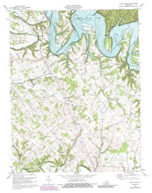
Cane Valley Topo Map Kentucky
To zoom in, hover over the map of Cane Valley
USGS Topo Quad 37085b3 - 1:24,000 scale
| Topo Map Name: | Cane Valley |
| USGS Topo Quad ID: | 37085b3 |
| Print Size: | ca. 21 1/4" wide x 27" high |
| Southeast Coordinates: | 37.125° N latitude / 85.25° W longitude |
| Map Center Coordinates: | 37.1875° N latitude / 85.3125° W longitude |
| U.S. State: | KY |
| Filename: | o37085b3.jpg |
| Download Map JPG Image: | Cane Valley topo map 1:24,000 scale |
| Map Type: | Topographic |
| Topo Series: | 7.5´ |
| Map Scale: | 1:24,000 |
| Source of Map Images: | United States Geological Survey (USGS) |
| Alternate Map Versions: |
Cane Valley KY 1953, updated 1955 Download PDF Buy paper map Cane Valley KY 1953, updated 1965 Download PDF Buy paper map Cane Valley KY 1970, updated 1972 Download PDF Buy paper map Cane Valley KY 1970, updated 1975 Download PDF Buy paper map Cane Valley KY 1970, updated 1979 Download PDF Buy paper map Cane Valley KY 1970, updated 1987 Download PDF Buy paper map Cane Valley KY 2010 Download PDF Buy paper map Cane Valley KY 2013 Download PDF Buy paper map Cane Valley KY 2016 Download PDF Buy paper map |
1:24,000 Topo Quads surrounding Cane Valley
> Back to 37085a1 at 1:100,000 scale
> Back to 37084a1 at 1:250,000 scale
> Back to U.S. Topo Maps home
Cane Valley topo map: Gazetteer
Cane Valley: Bends
Fisher Bend elevation 220m 721′Tibbs Bend elevation 216m 708′
Cane Valley: Cliffs
Buffalo Cliff elevation 219m 718′Little Bottom Cliff elevation 205m 672′
Cane Valley: Gaps
Buffalo Gap elevation 206m 675′Cane Valley: Populated Places
Absher elevation 276m 905′Cane Valley elevation 239m 784′
Coburg elevation 226m 741′
Holmes elevation 260m 853′
Kellyville elevation 231m 757′
Romine elevation 240m 787′
Cane Valley: Reservoirs
Green River Lake elevation 220m 721′Cane Valley: Ridges
Ferguson Ridge elevation 280m 918′Pike Ridge elevation 264m 866′
Cane Valley: Springs
Faulkner Sulphur Spring elevation 237m 777′Cane Valley: Streams
Butler Creek elevation 202m 662′Dry Fork elevation 206m 675′
Hutchison Branch elevation 236m 774′
Jones Branch elevation 202m 662′
Mill Creek elevation 195m 639′
Pelham Branch elevation 201m 659′
Pinch Creek elevation 182m 597′
Russell Branch elevation 202m 662′
Sandy Creek elevation 202m 662′
Sulphur Spring Branch elevation 199m 652′
White Oak Creek elevation 202m 662′
Cane Valley: Summits
Green River Hill elevation 243m 797′Cane Valley: Valleys
Ferguson Hollow elevation 202m 662′Cane Valley digital topo map on disk
Buy this Cane Valley topo map showing relief, roads, GPS coordinates and other geographical features, as a high-resolution digital map file on DVD:


