Mammoth Cave Topo Map Kentucky
To zoom in, hover over the map of Mammoth Cave
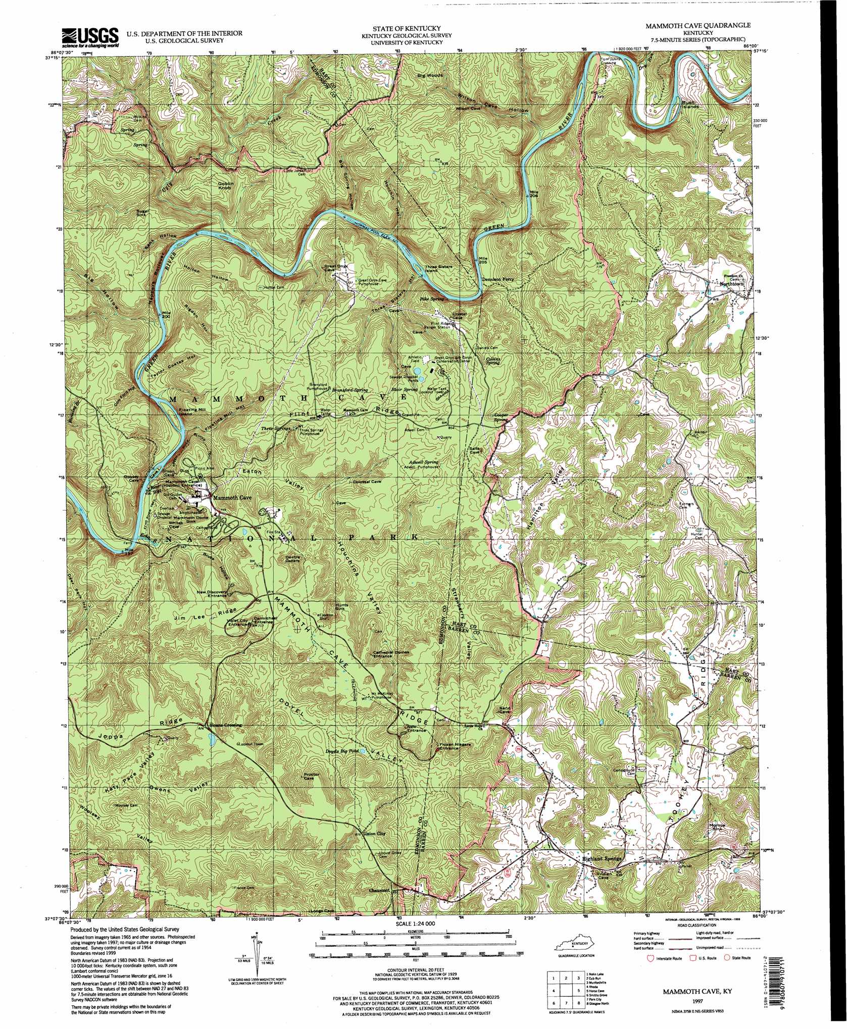
USGS Topo Quad 37086b1 - 1:24,000 scale
| Topo Map Name: | Mammoth Cave |
| USGS Topo Quad ID: | 37086b1 |
| Print Size: | ca. 21 1/4" wide x 27" high |
| Southeast Coordinates: | 37.125° N latitude / 86° W longitude |
| Map Center Coordinates: | 37.1875° N latitude / 86.0625° W longitude |
| U.S. State: | KY |
| Filename: | o37086b1.jpg |
| Download Map JPG Image: | Mammoth Cave topo map 1:24,000 scale |
| Map Type: | Topographic |
| Topo Series: | 7.5´ |
| Map Scale: | 1:24,000 |
| Source of Map Images: | United States Geological Survey (USGS) |
| Alternate Map Versions: |
Mammoth Cave KY 1965, updated 1973 Download PDF Buy paper map Mammoth Cave KY 1965, updated 1988 Download PDF Buy paper map Mammoth Cave KY 2010 Download PDF Buy paper map Mammoth Cave KY 2013 Download PDF Buy paper map Mammoth Cave KY 2016 Download PDF Buy paper map |
1:24,000 Topo Quads surrounding Mammoth Cave
Leitchfield |
Clarkson |
Millerstown |
Upton |
Hammonville |
Bee Spring |
Nolin Lake |
Cub Run |
Munfordville |
Canmer |
Brownsville |
Rhoda |
Mammoth Cave |
Horse Cave |
Park |
Bristow |
Smiths Grove |
Park City |
Glasgow North |
Hiseville |
Polkville |
Meador |
Lucas |
Glasgow South |
Temple Hill |
> Back to 37086a1 at 1:100,000 scale
> Back to 37086a1 at 1:250,000 scale
> Back to U.S. Topo Maps home
Mammoth Cave topo map: Gazetteer
Mammoth Cave: Basins
Double Cellars elevation 210m 688′Double Sinks elevation 215m 705′
Doyel Valley elevation 188m 616′
Eaton Valley elevation 180m 590′
Hamilton Valley elevation 197m 646′
Houchins Valley elevation 182m 597′
Hunts Sink elevation 207m 679′
Katy Pace Valley elevation 203m 666′
Mammoth Dome Sink elevation 176m 577′
Monroe Sink elevation 208m 682′
Owens Valley elevation 193m 633′
Strawberry Valley elevation 207m 679′
Sugar Sink elevation 169m 554′
Woolsey Valley elevation 163m 534′
Mammoth Cave: Cliffs
Nappers Rollover elevation 162m 531′Mammoth Cave: Islands
Bush Island elevation 134m 439′Cave Island elevation 134m 439′
Floating Mill Island elevation 135m 442′
Lucky Island elevation 134m 439′
Three Sisters Island elevation 132m 433′
Mammoth Cave: Lakes
Doyels Big Pond elevation 198m 649′Mammoth Cave: Populated Places
Chaumont elevation 261m 856′Highland Springs elevation 286m 938′
Mammoth Cave elevation 225m 738′
Northtown elevation 255m 836′
Sloans Crossing elevation 249m 816′
Tom Johns Crossing elevation 149m 488′
Union City elevation 268m 879′
Mammoth Cave: Ridges
Flint Ridge elevation 265m 869′Jim Lee Ridge elevation 245m 803′
Mammoth Cave Ridge elevation 260m 853′
Toohey Ridge elevation 275m 902′
Mammoth Cave: Springs
Adwell Spring elevation 237m 777′Blair Spring elevation 231m 757′
Bransford Spring elevation 228m 748′
Collins Spring elevation 237m 777′
Cooper Spring elevation 238m 780′
Pike Spring elevation 131m 429′
Three Springs elevation 226m 741′
Mammoth Cave: Streams
Dry Run elevation 134m 439′Echo River elevation 132m 433′
Piney Creek elevation 134m 439′
River Styx elevation 133m 436′
Ugly Creek elevation 133m 436′
Mammoth Cave: Summits
Goblin Knob elevation 224m 734′Mammoth Cave: Trails
Echo River Spring Trail elevation 143m 469′Green River Bluffs Trail elevation 188m 616′
Mammoth Cave: Valleys
Big Hollow elevation 134m 439′Big Spring Hollow elevation 214m 702′
Bruce Hollow elevation 179m 587′
Cow Ford Hollow elevation 139m 456′
Deer Park Hollow elevation 133m 436′
Floating Mill Hollow elevation 224m 734′
Holton Hollow elevation 140m 459′
Houchin Hollow elevation 132m 433′
Rigdon Hollow elevation 184m 603′
Sank Hollow elevation 170m 557′
Taylor Coates Hollow elevation 182m 597′
Three Sisters Hollow elevation 155m 508′
Wilson Cave Hollow elevation 138m 452′
Mammoth Cave: Woods
Big Woods elevation 225m 738′Mammoth Cave digital topo map on disk
Buy this Mammoth Cave topo map showing relief, roads, GPS coordinates and other geographical features, as a high-resolution digital map file on DVD: