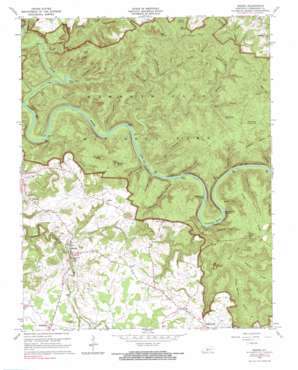
Rhoda Topo Map Kentucky
To zoom in, hover over the map of Rhoda
USGS Topo Quad 37086b2 - 1:24,000 scale
| Topo Map Name: | Rhoda |
| USGS Topo Quad ID: | 37086b2 |
| Print Size: | ca. 21 1/4" wide x 27" high |
| Southeast Coordinates: | 37.125° N latitude / 86.125° W longitude |
| Map Center Coordinates: | 37.1875° N latitude / 86.1875° W longitude |
| U.S. State: | KY |
| Filename: | o37086b2.jpg |
| Download Map JPG Image: | Rhoda topo map 1:24,000 scale |
| Map Type: | Topographic |
| Topo Series: | 7.5´ |
| Map Scale: | 1:24,000 |
| Source of Map Images: | United States Geological Survey (USGS) |
| Alternate Map Versions: |
Rhoda KY 1954, updated 1955 Download PDF Buy paper map Rhoda KY 1965, updated 1967 Download PDF Buy paper map Rhoda KY 1965, updated 1983 Download PDF Buy paper map Rhoda KY 2010 Download PDF Buy paper map Rhoda KY 2013 Download PDF Buy paper map Rhoda KY 2016 Download PDF Buy paper map |
1:24,000 Topo Quads surrounding Rhoda
> Back to 37086a1 at 1:100,000 scale
> Back to 37086a1 at 1:250,000 scale
> Back to U.S. Topo Maps home
Rhoda topo map: Gazetteer
Rhoda: Basins
Cedar Sink elevation 140m 459′Cedar Spring Valley elevation 170m 557′
Smith Valley elevation 178m 583′
Rhoda: Bends
Turnhole Bend elevation 134m 439′Rhoda: Islands
Boardcut Island elevation 134m 439′Crump Island elevation 134m 439′
Sand Cave Island elevation 134m 439′
Stice Island elevation 134m 439′
Rhoda: Lakes
First Creek Lake elevation 134m 439′Rhoda: Parks
Mammoth Cave National Park elevation 140m 459′Rhoda: Populated Places
Arthur elevation 208m 682′Chalybeate elevation 192m 629′
Elko elevation 225m 738′
Pig elevation 225m 738′
Rhoda elevation 173m 567′
Stockholm elevation 267m 875′
Rhoda: Ridges
Collie Ridge elevation 228m 748′Jappa Ridge elevation 229m 751′
Joppa Ridge elevation 238m 780′
Rhoda: Springs
Big Spring elevation 198m 649′Blue Spring elevation 191m 626′
Boiling Spring elevation 194m 636′
Good Spring elevation 206m 675′
Turnhole Spring elevation 135m 442′
Rhoda: Streams
Blair Spring Branch elevation 182m 597′Blowing Spring Branch elevation 134m 439′
Buffalo Creek elevation 130m 426′
Dry Branch elevation 132m 433′
Dry Prong Buffalo Creek elevation 130m 426′
First Creek elevation 134m 439′
Mill Branch elevation 155m 508′
Nolin River elevation 133m 436′
Pine Creek elevation 132m 433′
Running Branch elevation 132m 433′
Second Creek elevation 132m 433′
Wet Prong Buffalo Creek elevation 130m 426′
Rhoda: Summits
Brooks Knob elevation 254m 833′Crumps Knob elevation 256m 839′
Indian Hill elevation 227m 744′
Rhoda: Valleys
Carpenter Hollow elevation 133m 436′Chicken Hollow elevation 227m 744′
Cotton Gin Hollow elevation 137m 449′
Fishtrap Hollow elevation 135m 442′
McCoy Hollow elevation 134m 439′
Morrison Hollow elevation 179m 587′
Pigeon Hollow elevation 153m 501′
Poteet Hollow elevation 133m 436′
Raymer Hollow elevation 174m 570′
Raymond Hollow elevation 194m 636′
Sal Hollow elevation 134m 439′
Sand Cave Hollow elevation 167m 547′
Stillhouse Hollow elevation 132m 433′
Sugarcamp Hollow elevation 137m 449′
Sugarcamp Hollow elevation 133m 436′
Wildcat Hollow elevation 157m 515′
Rhoda digital topo map on disk
Buy this Rhoda topo map showing relief, roads, GPS coordinates and other geographical features, as a high-resolution digital map file on DVD:


