Nolin Lake Topo Map Kentucky
To zoom in, hover over the map of Nolin Lake
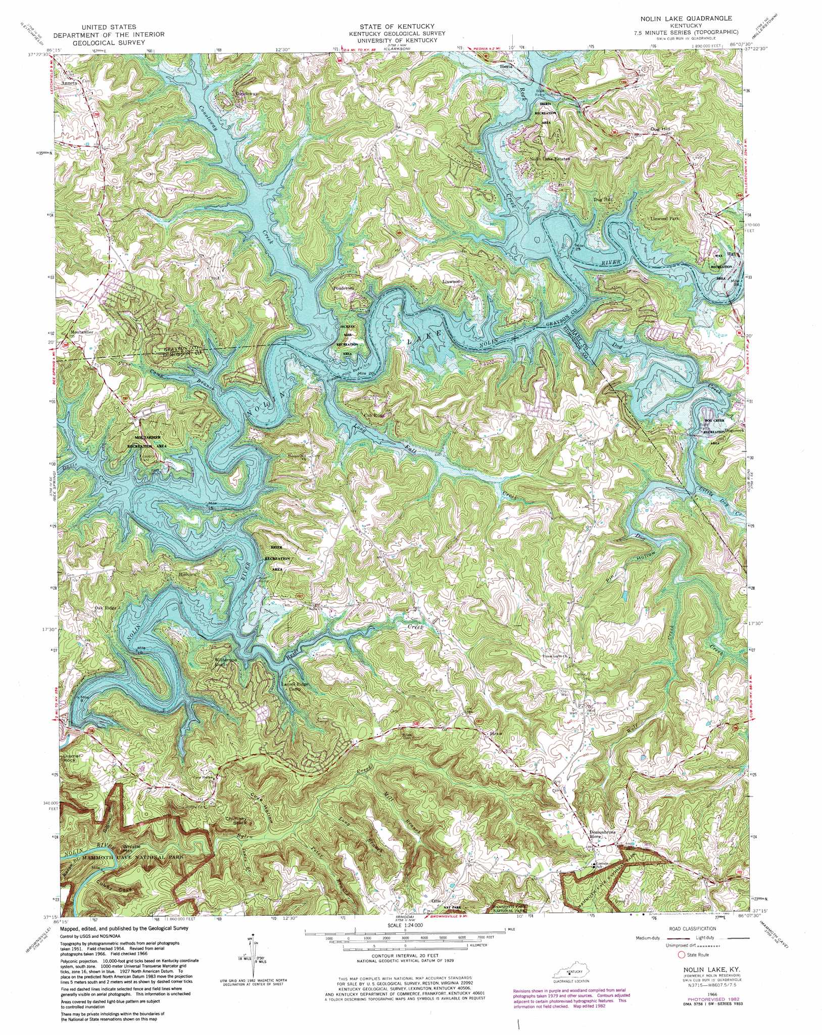
USGS Topo Quad 37086c2 - 1:24,000 scale
| Topo Map Name: | Nolin Lake |
| USGS Topo Quad ID: | 37086c2 |
| Print Size: | ca. 21 1/4" wide x 27" high |
| Southeast Coordinates: | 37.25° N latitude / 86.125° W longitude |
| Map Center Coordinates: | 37.3125° N latitude / 86.1875° W longitude |
| U.S. State: | KY |
| Filename: | o37086c2.jpg |
| Download Map JPG Image: | Nolin Lake topo map 1:24,000 scale |
| Map Type: | Topographic |
| Topo Series: | 7.5´ |
| Map Scale: | 1:24,000 |
| Source of Map Images: | United States Geological Survey (USGS) |
| Alternate Map Versions: |
Dickeys Mills KY 1954, updated 1955 Download PDF Buy paper map Dickeys Mills KY 1954, updated 1963 Download PDF Buy paper map Nolin Reservoir KY 1966, updated 1968 Download PDF Buy paper map Nolin Lake KY 1966, updated 1976 Download PDF Buy paper map Nolin Lake KY 1966, updated 1982 Download PDF Buy paper map Nolin Lake KY 2010 Download PDF Buy paper map Nolin Lake KY 2013 Download PDF Buy paper map Nolin Lake KY 2016 Download PDF Buy paper map |
1:24,000 Topo Quads surrounding Nolin Lake
Mcdaniels |
Madrid |
Big Clifty |
Summit |
Sonora |
Caneyville |
Leitchfield |
Clarkson |
Millerstown |
Upton |
Ready |
Bee Spring |
Nolin Lake |
Cub Run |
Munfordville |
Reedyville |
Brownsville |
Rhoda |
Mammoth Cave |
Horse Cave |
Bowling Green North |
Bristow |
Smiths Grove |
Park City |
Glasgow North |
> Back to 37086a1 at 1:100,000 scale
> Back to 37086a1 at 1:250,000 scale
> Back to U.S. Topo Maps home
Nolin Lake topo map: Gazetteer
Nolin Lake: Parks
Nolin Lake State Park elevation 192m 629′Nolin Lake: Pillars
Chimney Stack elevation 191m 626′Nolin Lake: Populated Places
Anneta elevation 234m 767′Conoloway elevation 197m 646′
Cub Run elevation 181m 593′
Dogcreek elevation 182m 597′
Dug Hill elevation 210m 688′
Hillview elevation 181m 593′
Iberia elevation 172m 564′
Linwood elevation 202m 662′
Linwood Park elevation 182m 597′
Moutardier elevation 218m 715′
Nolin Lake Estates elevation 181m 593′
Oak Ridge elevation 176m 577′
Ollie elevation 256m 839′
Ponderosa elevation 201m 659′
Straw elevation 245m 803′
Nolin Lake: Reservoirs
Nolin Lake elevation 171m 561′Nolin Lake: Streams
Brier Creek elevation 157m 515′Bylew Creek elevation 133m 436′
Cane Camp Branch elevation 157m 515′
Conoloway Creek elevation 157m 515′
Davis Creek elevation 157m 515′
Dog Creek elevation 157m 515′
Jones Branch elevation 141m 462′
Little Dog Creek elevation 157m 515′
Long Branch elevation 150m 492′
Long Fall Creek elevation 157m 515′
Mill Branch elevation 153m 501′
Peter Branch elevation 145m 475′
Raven Branch elevation 133m 436′
Robbins Branch elevation 132m 433′
Rock Creek elevation 157m 515′
Wolf Creek elevation 159m 521′
Nolin Lake: Summits
Dismal Rock elevation 163m 534′Dug Hill elevation 264m 866′
Whistle Mountain elevation 216m 708′
Nolin Lake: Valleys
Cove Hollow elevation 144m 472′Cubby Cove elevation 139m 456′
Pin Hollow elevation 157m 515′
Nolin Lake digital topo map on disk
Buy this Nolin Lake topo map showing relief, roads, GPS coordinates and other geographical features, as a high-resolution digital map file on DVD: