Rome Topo Map Indiana
To zoom in, hover over the map of Rome
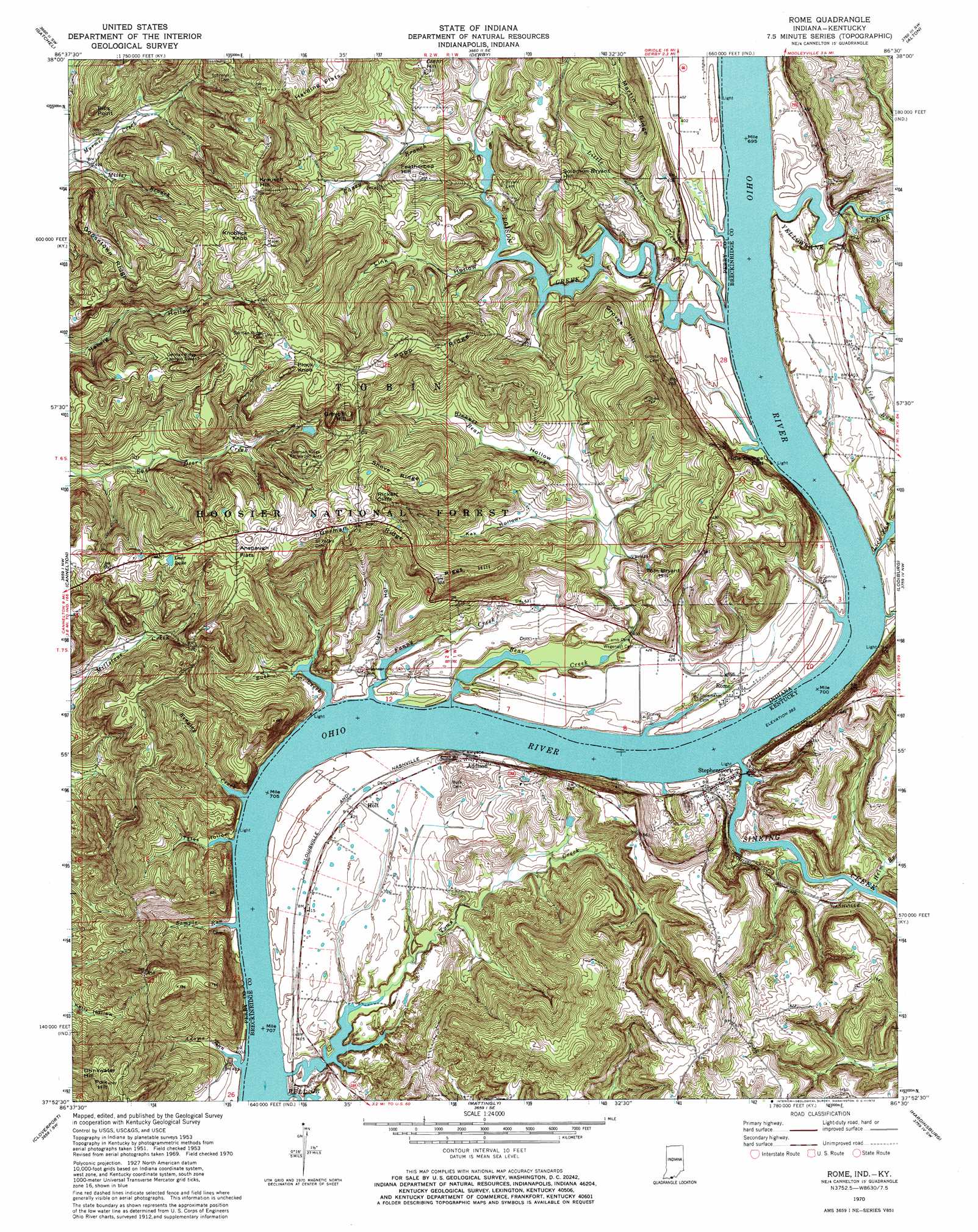
USGS Topo Quad 37086h5 - 1:24,000 scale
| Topo Map Name: | Rome |
| USGS Topo Quad ID: | 37086h5 |
| Print Size: | ca. 21 1/4" wide x 27" high |
| Southeast Coordinates: | 37.875° N latitude / 86.5° W longitude |
| Map Center Coordinates: | 37.9375° N latitude / 86.5625° W longitude |
| U.S. States: | IN, KY |
| Filename: | o37086h5.jpg |
| Download Map JPG Image: | Rome topo map 1:24,000 scale |
| Map Type: | Topographic |
| Topo Series: | 7.5´ |
| Map Scale: | 1:24,000 |
| Source of Map Images: | United States Geological Survey (USGS) |
| Alternate Map Versions: |
Rome IN 1953, updated 1955 Download PDF Buy paper map Rome IN 1953, updated 1966 Download PDF Buy paper map Rome IN 1970, updated 1972 Download PDF Buy paper map Rome IN 1993, updated 1996 Download PDF Buy paper map Rome IN 2011 Download PDF Buy paper map Rome IN 2013 Download PDF Buy paper map Rome IN 2016 Download PDF Buy paper map |
| FStopo: | US Forest Service topo Rome is available: Download FStopo PDF Download FStopo TIF |
1:24,000 Topo Quads surrounding Rome
Saint Meinrad |
Bristow |
Branchville |
Beechwood |
Leavenworth |
Fulda |
Gatchel |
Derby |
Alton |
New Amsterdam |
Tell City |
Cannelton |
Rome |
Lodiburg |
Irvington |
Pellville |
Cloverport |
Mattingly |
Hardinsburg |
Garfield |
Whitesville |
Fordsville |
Glen Dean |
Kingswood |
Custer |
> Back to 37086e1 at 1:100,000 scale
> Back to 37086a1 at 1:250,000 scale
> Back to U.S. Topo Maps home
Rome topo map: Gazetteer
Rome: Cliffs
Bills Point elevation 195m 639′Idle George Cliff elevation 169m 554′
Rickert Cliffs elevation 228m 748′
Rome: Flats
Anspaugh Flats elevation 223m 731′Harding Flats elevation 215m 705′
Rome: Populated Places
Addison elevation 128m 419′Hardingrove elevation 128m 419′
Holt elevation 130m 426′
Lauer elevation 122m 400′
Rome elevation 125m 410′
Stephensport elevation 131m 429′
Rome: Reservoirs
Deer Lake elevation 214m 702′East Deer Pond elevation 205m 672′
Gerber Pond elevation 207m 679′
Rome: Ridges
German Ridge elevation 198m 649′Goosetown Ridge elevation 207m 679′
Martin Ridge elevation 199m 652′
Popp Ridge elevation 235m 770′
Shove Ridge elevation 230m 754′
Rome: Streams
Adams Run elevation 118m 387′Bear Creek elevation 120m 393′
Buck Creek elevation 119m 390′
Bull Creek elevation 116m 380′
Caney Branch elevation 119m 390′
Fanny Creek elevation 119m 390′
Helm Branch elevation 118m 387′
Kingley Creek elevation 117m 383′
Lick Run elevation 117m 383′
Little Poison Creek elevation 116m 380′
Poison Creek elevation 116m 380′
Sample Run elevation 118m 387′
Sinking Creek elevation 116m 380′
Town Creek elevation 118m 387′
Yellowbank Creek elevation 116m 380′
Rome: Summits
Featherbed Hill elevation 163m 534′Greybill Hill elevation 245m 803′
Groves Hill elevation 183m 600′
Knoblick Knob elevation 238m 780′
Krausch Hill elevation 198m 649′
Plock Knob elevation 246m 807′
Polk Hill elevation 235m 770′
Riggs Hill elevation 223m 731′
Solomon Bryant Hill elevation 183m 600′
Tom Bryant Hill elevation 182m 597′
Rome: Valleys
Clear Lick Hollow elevation 121m 396′Kak Hollow elevation 127m 416′
Link Hollow elevation 117m 383′
Rickert Hollow elevation 126m 413′
Tates Hollow elevation 126m 413′
Rome digital topo map on disk
Buy this Rome topo map showing relief, roads, GPS coordinates and other geographical features, as a high-resolution digital map file on DVD: