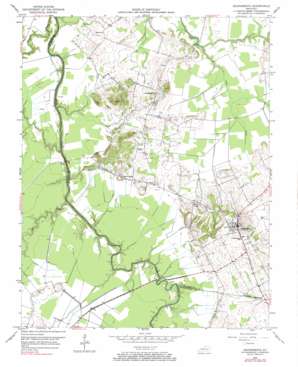
Sacramento Topo Map Kentucky
To zoom in, hover over the map of Sacramento
USGS Topo Quad 37087d3 - 1:24,000 scale
| Topo Map Name: | Sacramento |
| USGS Topo Quad ID: | 37087d3 |
| Print Size: | ca. 21 1/4" wide x 27" high |
| Southeast Coordinates: | 37.375° N latitude / 87.25° W longitude |
| Map Center Coordinates: | 37.4375° N latitude / 87.3125° W longitude |
| U.S. State: | KY |
| Filename: | o37087d3.jpg |
| Download Map JPG Image: | Sacramento topo map 1:24,000 scale |
| Map Type: | Topographic |
| Topo Series: | 7.5´ |
| Map Scale: | 1:24,000 |
| Source of Map Images: | United States Geological Survey (USGS) |
| Alternate Map Versions: |
Sacramento KY 1952, updated 1953 Download PDF Buy paper map Sacramento KY 1952, updated 1973 Download PDF Buy paper map Sacramento KY 2010 Download PDF Buy paper map Sacramento KY 2013 Download PDF Buy paper map Sacramento KY 2016 Download PDF Buy paper map |
1:24,000 Topo Quads surrounding Sacramento
> Back to 37087a1 at 1:100,000 scale
> Back to 37086a1 at 1:250,000 scale
> Back to U.S. Topo Maps home
Sacramento topo map: Gazetteer
Sacramento: Airports
Baggett Farms Airport elevation 117m 383′Shannon Field elevation 131m 429′
Sacramento: Bridges
Brazzel Bridge elevation 112m 367′Coffman Bridge elevation 114m 374′
Sacramento: Canals
Pond Drain elevation 115m 377′Sacramento: Populated Places
Poplar Grove elevation 138m 452′Sacramento elevation 150m 492′
Sacramento: Streams
Elk Creek elevation 110m 360′Narge Creek elevation 107m 351′
Sacramento digital topo map on disk
Buy this Sacramento topo map showing relief, roads, GPS coordinates and other geographical features, as a high-resolution digital map file on DVD:


