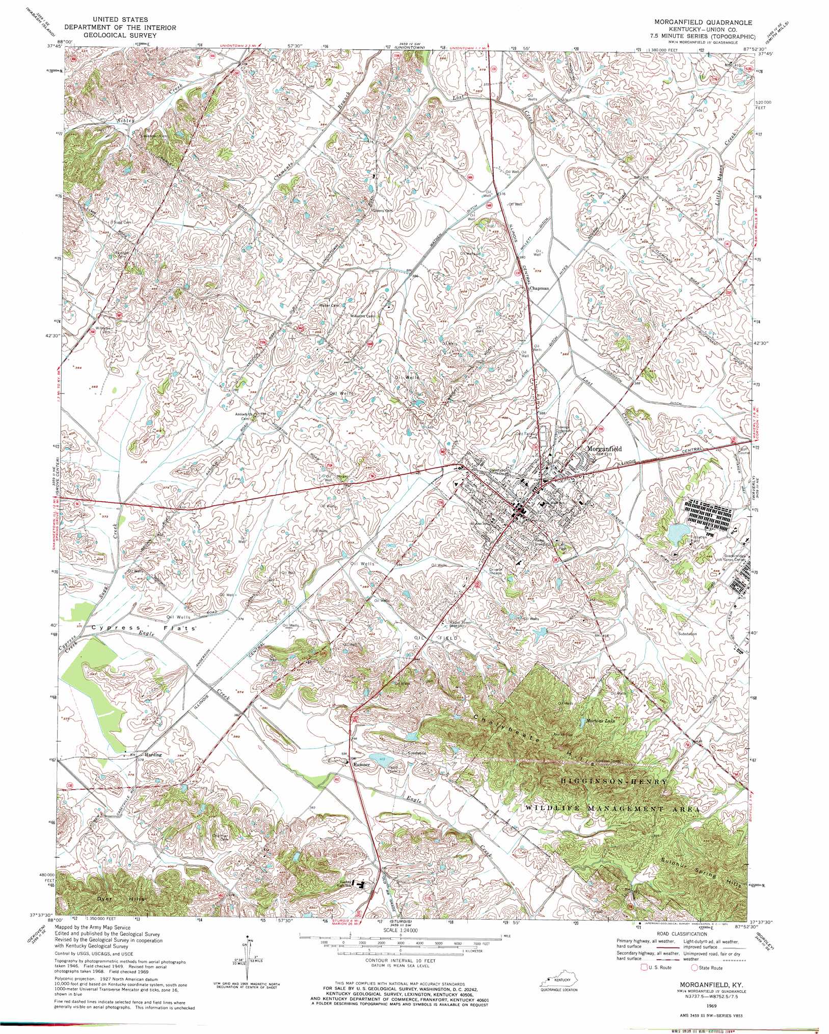
Morganfield Topo Map Kentucky
To zoom in, hover over the map of Morganfield
USGS Topo Quad 37087f8 - 1:24,000 scale
| Topo Map Name: | Morganfield |
| USGS Topo Quad ID: | 37087f8 |
| Print Size: | ca. 21 1/4" wide x 27" high |
| Southeast Coordinates: | 37.625° N latitude / 87.875° W longitude |
| Map Center Coordinates: | 37.6875° N latitude / 87.9375° W longitude |
| U.S. State: | KY |
| Filename: | o37087f8.jpg |
| Download Map JPG Image: | Morganfield topo map 1:24,000 scale |
| Map Type: | Topographic |
| Topo Series: | 7.5´ |
| Map Scale: | 1:24,000 |
| Source of Map Images: | United States Geological Survey (USGS) |
| Alternate Map Versions: |
Morganfield KY 1949, updated 1966 Download PDF Buy paper map Morganfield KY 1951 Download PDF Buy paper map Morganfield KY 1969, updated 1971 Download PDF Buy paper map Morganfield KY 2010 Download PDF Buy paper map Morganfield KY 2013 Download PDF Buy paper map Morganfield KY 2016 Download PDF Buy paper map |
1:24,000 Topo Quads surrounding Morganfield
New Haven |
Emma |
Mount Vernon |
Caborn |
West Franklin |
New Haven Sw |
Wabash Island |
Uniontown |
Smith Mills |
Wilson |
Shawneetown |
Grove Center |
Morganfield |
Waverley |
Poole |
Saline Mines |
Dekoven |
Sturgis |
Bordley |
Dixon |
Cave In Rock |
Repton |
Blackford |
Providence |
Nebo |
> Back to 37087e1 at 1:100,000 scale
> Back to 37086a1 at 1:250,000 scale
> Back to U.S. Topo Maps home
Morganfield topo map: Gazetteer
Morganfield: Canals
Higginson Ditch elevation 116m 380′Line Ditch elevation 116m 380′
Wathen Ditch elevation 115m 377′
Willett Ditch elevation 113m 370′
Morganfield: Flats
Cypress Flats elevation 113m 370′Morganfield: Parks
Higginson-Henry Wildlife Management Area elevation 184m 603′Morganfield: Populated Places
Chapman elevation 116m 380′Hamner elevation 122m 400′
Harding elevation 115m 377′
Morganfield elevation 133m 436′
Morganfield: Ranges
Chalybeate Hills elevation 190m 623′Dyer Hills elevation 142m 465′
Sulphur Spring Hills elevation 191m 626′
Morganfield: Reservoirs
Mortons Lake elevation 142m 465′Morganfield: Streams
Eagle Creek elevation 113m 370′Sugg Creek elevation 113m 370′
Morganfield digital topo map on disk
Buy this Morganfield topo map showing relief, roads, GPS coordinates and other geographical features, as a high-resolution digital map file on DVD: