Yankeetown Topo Map Indiana
To zoom in, hover over the map of Yankeetown
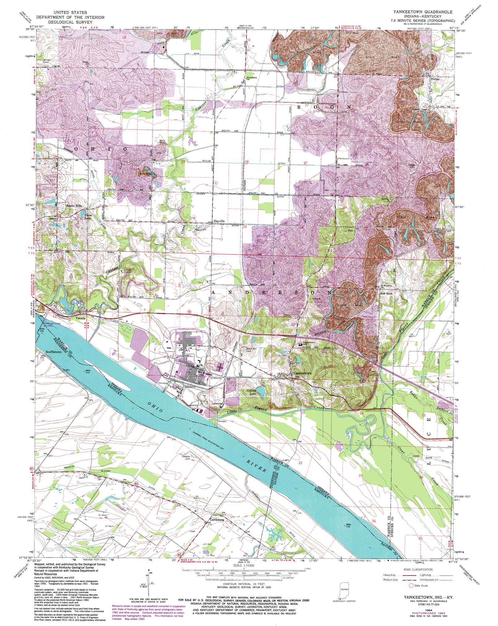
USGS Topo Quad 37087h3 - 1:24,000 scale
| Topo Map Name: | Yankeetown |
| USGS Topo Quad ID: | 37087h3 |
| Print Size: | ca. 21 1/4" wide x 27" high |
| Southeast Coordinates: | 37.875° N latitude / 87.25° W longitude |
| Map Center Coordinates: | 37.9375° N latitude / 87.3125° W longitude |
| U.S. States: | IN, KY |
| Filename: | o37087h3.jpg |
| Download Map JPG Image: | Yankeetown topo map 1:24,000 scale |
| Map Type: | Topographic |
| Topo Series: | 7.5´ |
| Map Scale: | 1:24,000 |
| Source of Map Images: | United States Geological Survey (USGS) |
| Alternate Map Versions: |
Yankeetown IN 1951, updated 1952 Download PDF Buy paper map Yankeetown IN 1964, updated 1966 Download PDF Buy paper map Yankeetown IN 1964, updated 1973 Download PDF Buy paper map Yankeetown IN 1964, updated 1981 Download PDF Buy paper map Yankeetown IN 1964, updated 1984 Download PDF Buy paper map Yankeetown IN 2010 Download PDF Buy paper map Yankeetown IN 2013 Download PDF Buy paper map Yankeetown IN 2016 Download PDF Buy paper map |
1:24,000 Topo Quads surrounding Yankeetown
Haubstadt |
Elberfeld |
Lynnville |
Folsomville |
Holland |
Evansville North |
Daylight |
Boonville |
De Gonia Springs |
Chrisney |
Evansville South |
Newburgh |
Yankeetown |
Richland City |
Rockport |
Henderson |
Spottsville |
Reed |
Owensboro West |
Owensboro East |
Robards |
Delaware |
Curdsville |
Panther |
Sutherland |
> Back to 37087e1 at 1:100,000 scale
> Back to 37086a1 at 1:250,000 scale
> Back to U.S. Topo Maps home
Yankeetown topo map: Gazetteer
Yankeetown: Canals
Griffith Slough Ditch elevation 113m 370′Horsman Ditch elevation 113m 370′
Kaiser Ditch elevation 119m 390′
Koehler Ditch elevation 119m 390′
McCool Ditch elevation 116m 380′
Mitchem Ditch elevation 117m 383′
Summer Pecka Ditch elevation 116m 380′
Taylor Ditch elevation 119m 390′
Yankeetown: Dams
U S Dam Number Four elevation 107m 351′Yankeetown: Populated Places
Carlinburg elevation 116m 380′Dayville elevation 119m 390′
Pelzer elevation 128m 419′
Pyeattville elevation 113m 370′
Red Bush elevation 125m 410′
Rustic Hills elevation 139m 456′
Scuffletown elevation 115m 377′
Vanada elevation 117m 383′
Yankeetown elevation 137m 449′
Yankeetown: Reservoirs
Chase Lake elevation 122m 400′Collins Lake elevation 131m 429′
Yankeetown: Streams
Baker Creek elevation 109m 357′Clear Creek elevation 109m 357′
Cypress Creek elevation 106m 347′
Robert Richard Drain elevation 109m 357′
Yankeetown digital topo map on disk
Buy this Yankeetown topo map showing relief, roads, GPS coordinates and other geographical features, as a high-resolution digital map file on DVD: