Golconda Topo Map Kentucky
To zoom in, hover over the map of Golconda
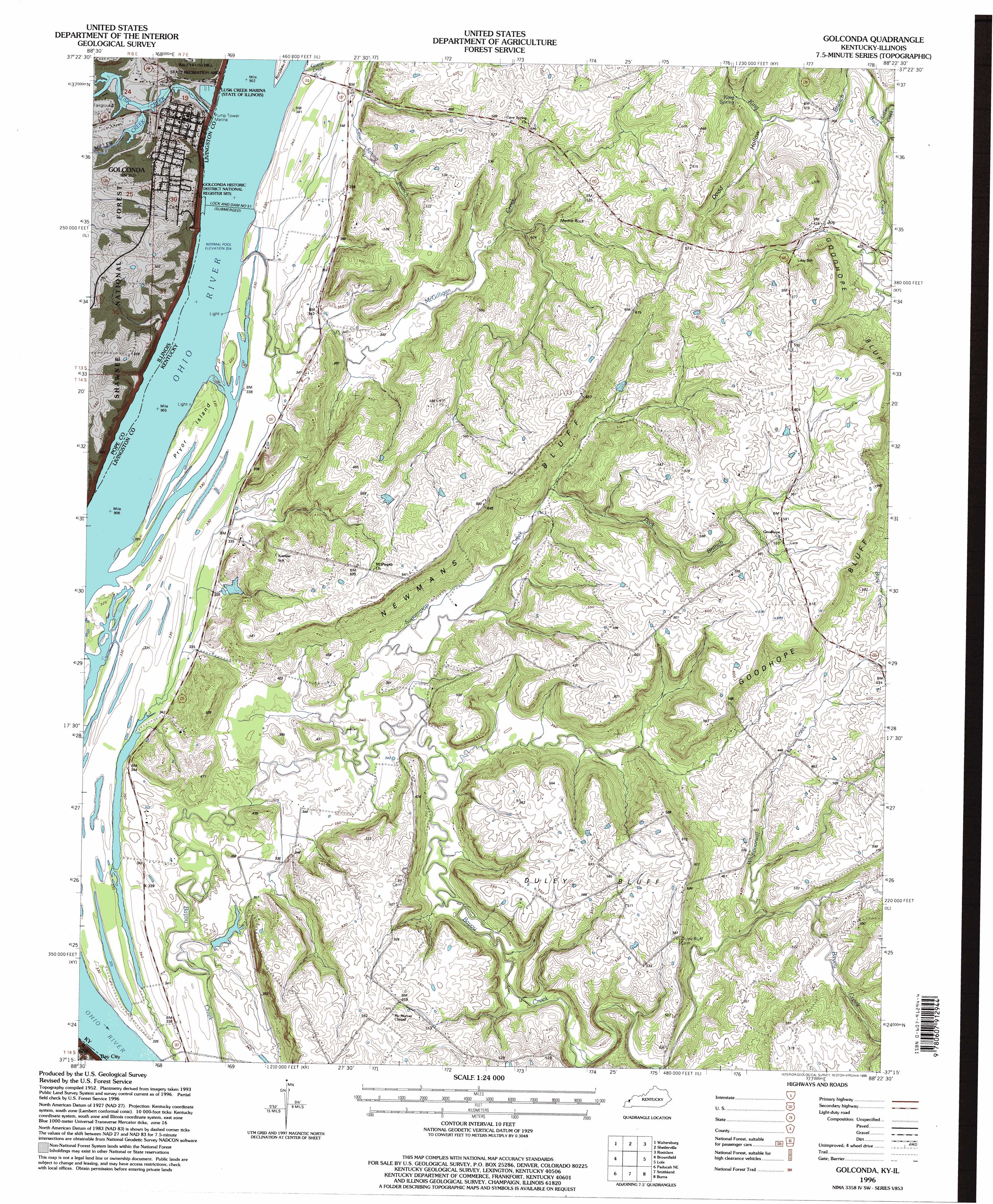
USGS Topo Quad 37088c4 - 1:24,000 scale
| Topo Map Name: | Golconda |
| USGS Topo Quad ID: | 37088c4 |
| Print Size: | ca. 21 1/4" wide x 27" high |
| Southeast Coordinates: | 37.25° N latitude / 88.375° W longitude |
| Map Center Coordinates: | 37.3125° N latitude / 88.4375° W longitude |
| U.S. States: | KY, IL |
| Filename: | o37088c4.jpg |
| Download Map JPG Image: | Golconda topo map 1:24,000 scale |
| Map Type: | Topographic |
| Topo Series: | 7.5´ |
| Map Scale: | 1:24,000 |
| Source of Map Images: | United States Geological Survey (USGS) |
| Alternate Map Versions: |
Golconda IL 1954, updated 1955 Download PDF Buy paper map Golconda IL 1954, updated 1970 Download PDF Buy paper map Golconda IL 1954, updated 1988 Download PDF Buy paper map Golconda IL 1996, updated 1998 Download PDF Buy paper map Golconda IL 2011 Download PDF Buy paper map Golconda IL 2015 Download PDF Buy paper map |
| FStopo: | US Forest Service topo Golconda is available: Download FStopo PDF Download FStopo TIF |
1:24,000 Topo Quads surrounding Golconda
Stonefort |
Eddyville |
Herod |
Karbers Ridge |
Saline Mines |
Glendale |
Waltersburg |
Shetlerville |
Rosiclare |
Cave In Rock |
Reevesville |
Brownfield |
Golconda |
Lola |
Salem |
Metropolis |
Paducah Ne |
Smithland |
Burna |
Dycusburg |
Paducah West |
Paducah East |
Little Cypress |
Calvert City |
Grand Rivers |
> Back to 37088a1 at 1:100,000 scale
> Back to 37088a1 at 1:250,000 scale
> Back to U.S. Topo Maps home
Golconda topo map: Gazetteer
Golconda: Cliffs
Duley Bluff elevation 171m 561′Goodhope Bluff elevation 170m 557′
Mantle Rock elevation 136m 446′
Newmans Bluff elevation 145m 475′
Golconda: Dams
Lock and Dam Number 51 elevation 99m 324′Lock and Dam Number 51 elevation 99m 324′
Golconda: Islands
Pryor Island elevation 100m 328′Golconda: Parks
Golconda Historic District elevation 109m 357′Golconda Historic District National Register Site elevation 99m 324′
Ohio River Recreation Area elevation 127m 416′
Golconda: Populated Places
Golconda elevation 108m 354′Joy elevation 129m 423′
Golconda: Springs
King Spring elevation 128m 419′Golconda: Streams
Givens Creek elevation 99m 324′Lusk Creek elevation 99m 324′
McGilligan Creek elevation 99m 324′
Miller Creek elevation 99m 324′
Peck Branch elevation 114m 374′
Sadler Creek elevation 115m 377′
Sugarcamp Creek elevation 101m 331′
Whippoorwill Creek elevation 124m 406′
Golconda: Summits
Rauchfuss Hill elevation 171m 561′Rauchfuss Hill elevation 171m 561′
Golconda: Valleys
Dodd Hollow elevation 117m 383′Golconda digital topo map on disk
Buy this Golconda topo map showing relief, roads, GPS coordinates and other geographical features, as a high-resolution digital map file on DVD: