Reevesville Topo Map Illinois
To zoom in, hover over the map of Reevesville
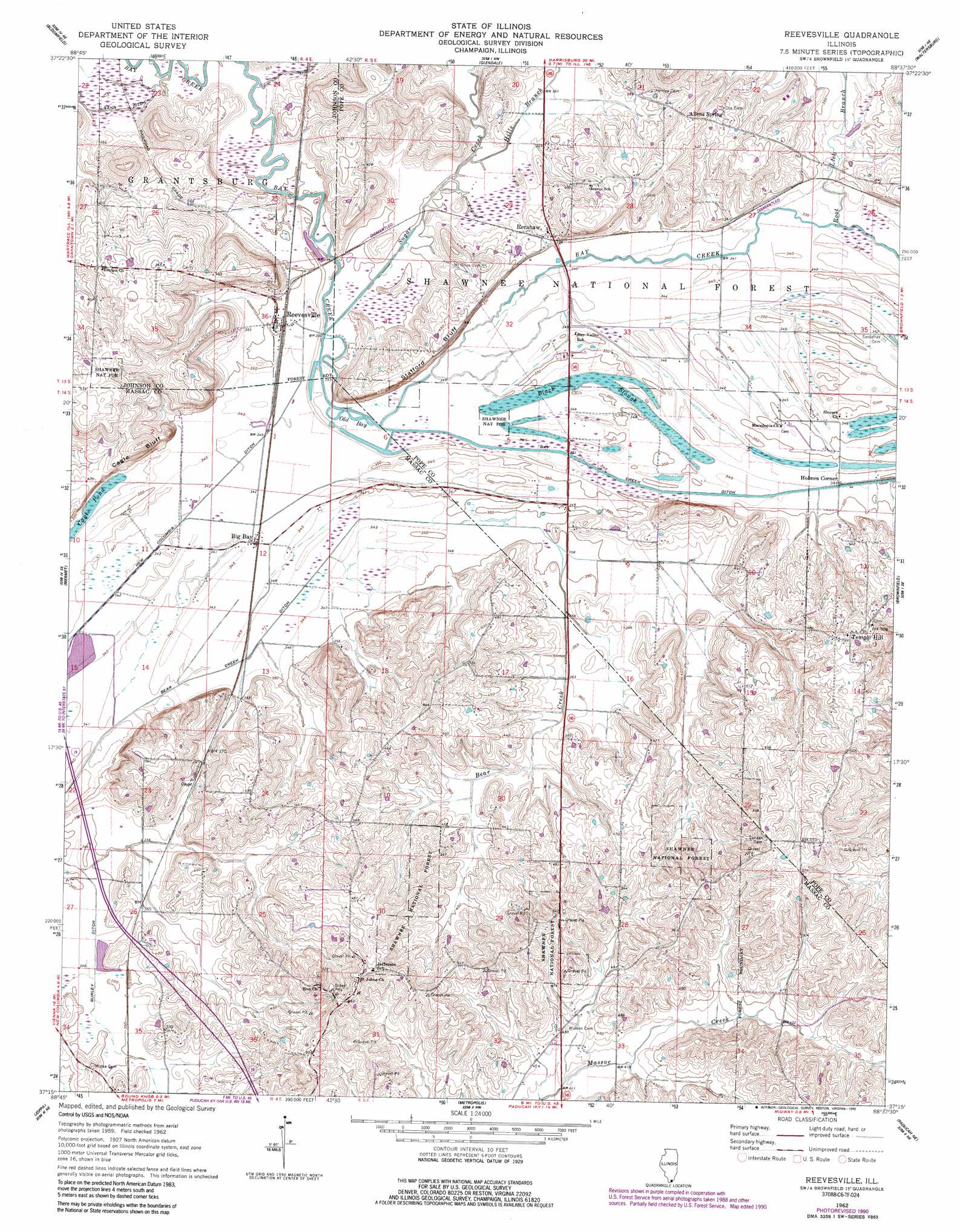
USGS Topo Quad 37088c6 - 1:24,000 scale
| Topo Map Name: | Reevesville |
| USGS Topo Quad ID: | 37088c6 |
| Print Size: | ca. 21 1/4" wide x 27" high |
| Southeast Coordinates: | 37.25° N latitude / 88.625° W longitude |
| Map Center Coordinates: | 37.3125° N latitude / 88.6875° W longitude |
| U.S. State: | IL |
| Filename: | o37088c6.jpg |
| Download Map JPG Image: | Reevesville topo map 1:24,000 scale |
| Map Type: | Topographic |
| Topo Series: | 7.5´ |
| Map Scale: | 1:24,000 |
| Source of Map Images: | United States Geological Survey (USGS) |
| Alternate Map Versions: |
Reevesville IL 1962, updated 1963 Download PDF Buy paper map Reevesville IL 1962, updated 1981 Download PDF Buy paper map Reevesville IL 1962, updated 1990 Download PDF Buy paper map Reevesville IL 1996, updated 1998 Download PDF Buy paper map Reevesville IL 2012 Download PDF Buy paper map Reevesville IL 2015 Download PDF Buy paper map |
| FStopo: | US Forest Service topo Reevesville is available: Download FStopo PDF Download FStopo TIF |
1:24,000 Topo Quads surrounding Reevesville
Goreville |
Creal Springs |
Stonefort |
Eddyville |
Herod |
Vienna |
Bloomfield |
Glendale |
Waltersburg |
Shetlerville |
Karnak |
Mermet |
Reevesville |
Brownfield |
Golconda |
Bandana |
Joppa |
Metropolis |
Paducah Ne |
Smithland |
La Center |
Heath |
Paducah West |
Paducah East |
Little Cypress |
> Back to 37088a1 at 1:100,000 scale
> Back to 37088a1 at 1:250,000 scale
> Back to U.S. Topo Maps home
Reevesville topo map: Gazetteer
Reevesville: Canals
Bay Creek Ditch elevation 103m 337′Bear Creek Ditch elevation 104m 341′
Gann Ditch elevation 107m 351′
Gurley Ditch elevation 105m 344′
Reevesville: Cliffs
Cagle Bluff elevation 112m 367′Reevesville: Guts
Black Slough elevation 102m 334′Reevesville: Lakes
Cagle Pond elevation 102m 334′Old Bay elevation 104m 341′
Reevesville: Populated Places
Allens Spring elevation 147m 482′Big Bay elevation 106m 347′
Holmes Corner elevation 106m 347′
Perkins (historical) elevation 110m 360′
Reevesville elevation 107m 351′
Renshaw elevation 115m 377′
Temple Hill elevation 157m 515′
Reevesville: Post Offices
Temple Hill Post Office elevation 162m 531′Reevesville: Streams
Bear Creek elevation 106m 347′Hills Branch elevation 104m 341′
Root Lick Branch elevation 100m 328′
Sugar Creek elevation 104m 341′
Reevesville: Summits
Stafford Bluff elevation 141m 462′Reevesville digital topo map on disk
Buy this Reevesville topo map showing relief, roads, GPS coordinates and other geographical features, as a high-resolution digital map file on DVD: