Dekoven Topo Map Kentucky
To zoom in, hover over the map of Dekoven
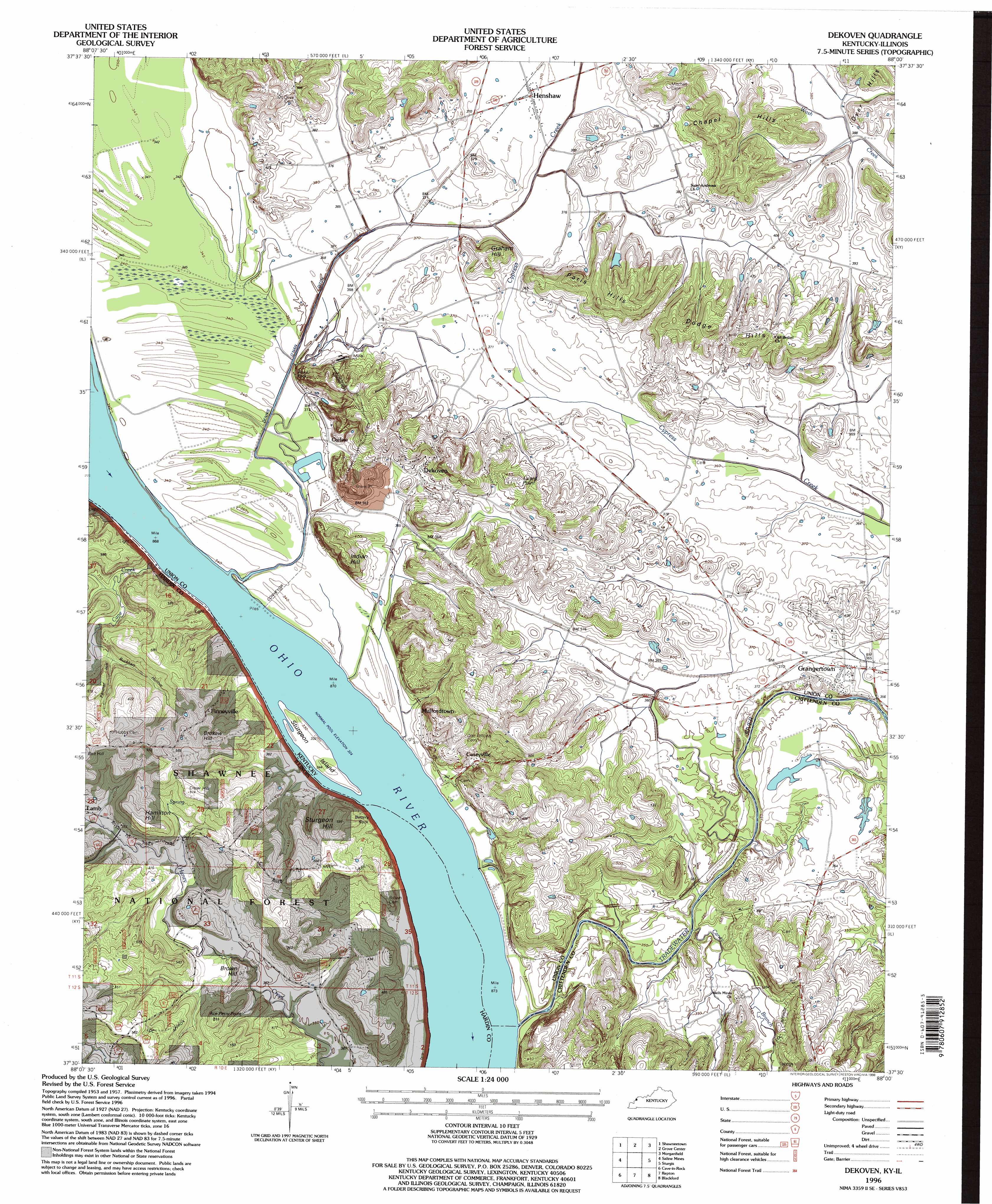
USGS Topo Quad 37088e1 - 1:24,000 scale
| Topo Map Name: | Dekoven |
| USGS Topo Quad ID: | 37088e1 |
| Print Size: | ca. 21 1/4" wide x 27" high |
| Southeast Coordinates: | 37.5° N latitude / 88° W longitude |
| Map Center Coordinates: | 37.5625° N latitude / 88.0625° W longitude |
| U.S. States: | KY, IL |
| Filename: | o37088e1.jpg |
| Download Map JPG Image: | Dekoven topo map 1:24,000 scale |
| Map Type: | Topographic |
| Topo Series: | 7.5´ |
| Map Scale: | 1:24,000 |
| Source of Map Images: | United States Geological Survey (USGS) |
| Alternate Map Versions: |
Dekoven KY 1953, updated 1954 Download PDF Buy paper map Dekoven KY 1959, updated 1960 Download PDF Buy paper map Dekoven KY 1959, updated 1977 Download PDF Buy paper map Dekoven KY 1959, updated 1991 Download PDF Buy paper map Dekoven KY 1996, updated 1998 Download PDF Buy paper map Dekoven KY 2011 Download PDF Buy paper map Dekoven KY 2013 Download PDF Buy paper map Dekoven KY 2016 Download PDF Buy paper map |
| FStopo: | US Forest Service topo Dekoven is available: Download FStopo PDF Download FStopo TIF |
1:24,000 Topo Quads surrounding Dekoven
Ridgway |
New Haven Sw |
Wabash Island |
Uniontown |
Smith Mills |
Equality |
Shawneetown |
Grove Center |
Morganfield |
Waverley |
Karbers Ridge |
Saline Mines |
Dekoven |
Sturgis |
Bordley |
Rosiclare |
Cave In Rock |
Repton |
Blackford |
Providence |
Lola |
Salem |
Marion |
Shady Grove |
Dalton |
> Back to 37088e1 at 1:100,000 scale
> Back to 37088a1 at 1:250,000 scale
> Back to U.S. Topo Maps home
Dekoven topo map: Gazetteer
Dekoven: Canals
Dennis O'Nan Ditch elevation 101m 331′Dekoven: Cliffs
Battery Rock elevation 100m 328′Dekoven: Islands
Sturgeon Island elevation 100m 328′Dekoven: Pillars
Anvil Rock elevation 117m 383′Dekoven: Populated Places
Caseyville elevation 112m 367′Curlew elevation 116m 380′
Dekoven elevation 122m 400′
Finneyville elevation 155m 508′
Grangertown elevation 112m 367′
Henshaw elevation 113m 370′
Lamb elevation 119m 390′
Mulfordtown elevation 113m 370′
Dekoven: Ranges
Chapel Hills elevation 144m 472′Dodge Hills elevation 165m 541′
Paris Hills elevation 148m 485′
Dekoven: Streams
Cane Creek elevation 100m 328′Caney Branch elevation 100m 328′
Tradewater River elevation 99m 324′
Wardens Slough elevation 99m 324′
Dekoven: Summits
Ace Perry Point elevation 168m 551′Brokaw Hill elevation 193m 633′
Brown Hill elevation 128m 419′
Crow Hill elevation 174m 570′
Graham Hill elevation 139m 456′
Hamilton Hill elevation 175m 574′
Indian Hill elevation 154m 505′
Lizard Point elevation 139m 456′
Sturgeon Hill elevation 181m 593′
Dekoven: Valleys
Buckhart Hollow elevation 109m 357′Green Chapel Hollow elevation 109m 357′
Panther Hollow elevation 110m 360′
Dekoven digital topo map on disk
Buy this Dekoven topo map showing relief, roads, GPS coordinates and other geographical features, as a high-resolution digital map file on DVD: