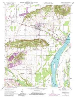
Shawneetown Topo Map Illinois
To zoom in, hover over the map of Shawneetown
USGS Topo Quad 37088f2 - 1:24,000 scale
| Topo Map Name: | Shawneetown |
| USGS Topo Quad ID: | 37088f2 |
| Print Size: | ca. 21 1/4" wide x 27" high |
| Southeast Coordinates: | 37.625° N latitude / 88.125° W longitude |
| Map Center Coordinates: | 37.6875° N latitude / 88.1875° W longitude |
| U.S. States: | IL, KY |
| Filename: | o37088f2.jpg |
| Download Map JPG Image: | Shawneetown topo map 1:24,000 scale |
| Map Type: | Topographic |
| Topo Series: | 7.5´ |
| Map Scale: | 1:24,000 |
| Source of Map Images: | United States Geological Survey (USGS) |
| Alternate Map Versions: |
Shawneetown IL 1959, updated 1960 Download PDF Buy paper map Shawneetown IL 1959, updated 1969 Download PDF Buy paper map Shawneetown IL 1959, updated 1990 Download PDF Buy paper map Shawneetown IL 1996, updated 1998 Download PDF Buy paper map Shawneetown IL 2010 Download PDF Buy paper map Shawneetown IL 2015 Download PDF Buy paper map |
| FStopo: | US Forest Service topo Shawneetown is available: Download FStopo PDF Download FStopo TIF |
1:24,000 Topo Quads surrounding Shawneetown
> Back to 37088e1 at 1:100,000 scale
> Back to 37088a1 at 1:250,000 scale
> Back to U.S. Topo Maps home
Shawneetown topo map: Gazetteer
Shawneetown: Airports
Dortch Private Strip elevation 115m 377′Shawneetown: Canals
Little Cypress Ditch elevation 107m 351′Shawneetown: Crossings
Talley Ferry (historical) elevation 99m 324′Shawneetown: Dams
Eagle Number 1 Fresh Water Lake Dam elevation 113m 370′Eagle Number 2 Lake Dam elevation 107m 351′
Fresh Water Lake Dam elevation 111m 364′
Illinois No Name Number 2017 Dam elevation 109m 357′
Shawneetown: Guts
Cypress Slough elevation 101m 331′Shawneetown: Lakes
Dixon Pond elevation 101m 331′Little Ditch Lake elevation 101m 331′
Long Pond elevation 102m 334′
Muddy Pond elevation 104m 341′
State Lake elevation 101m 331′
Shawneetown: Populated Places
Bowlesville (historical) elevation 128m 419′Junction elevation 110m 360′
Old Shawneetown elevation 107m 351′
Shawneetown elevation 122m 400′
Shawneetown: Ranges
Shawneetown Hills elevation 139m 456′Shawneetown: Reservoirs
Eagle Number 1 Fresh Water Lake elevation 113m 370′Eagle Number 2 Lake elevation 107m 351′
Fresh Water Lake elevation 111m 364′
Shawneetown: Streams
Turkey Creek elevation 101m 331′Shawneetown: Summits
Gold Hill elevation 214m 702′Shawneetown: Valleys
Kuykendall Valley elevation 113m 370′Shawneetown digital topo map on disk
Buy this Shawneetown topo map showing relief, roads, GPS coordinates and other geographical features, as a high-resolution digital map file on DVD:


