Thebes Topo Map Illinois
To zoom in, hover over the map of Thebes
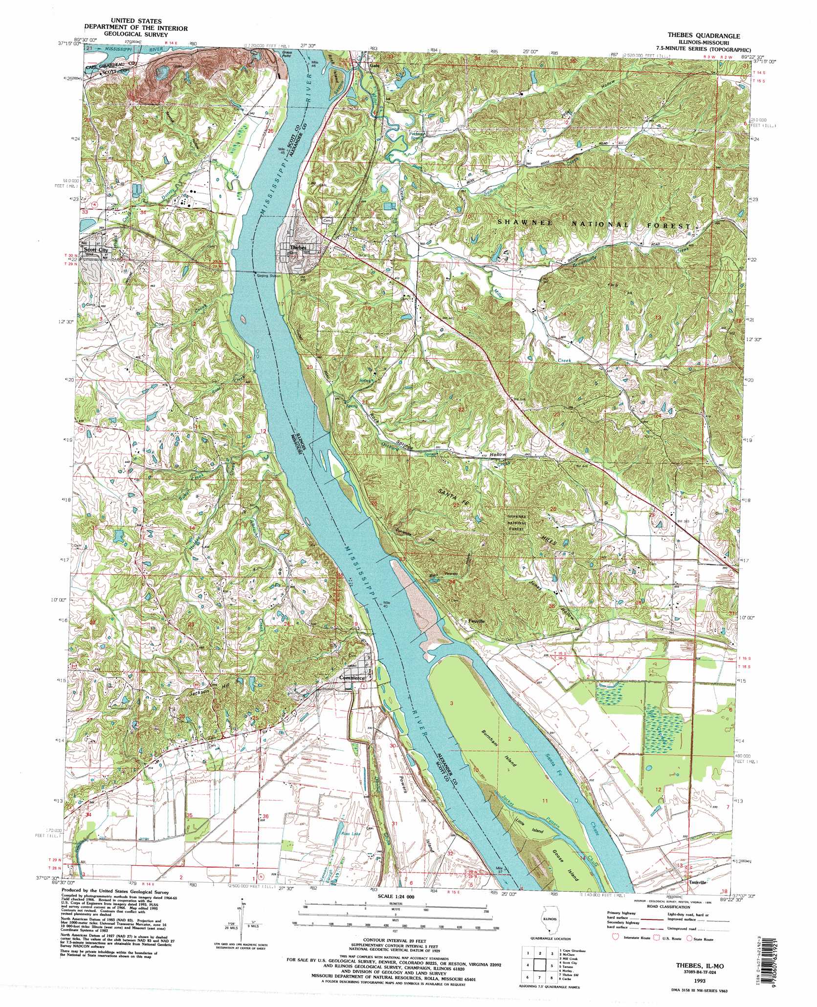
USGS Topo Quad 37089b4 - 1:24,000 scale
| Topo Map Name: | Thebes |
| USGS Topo Quad ID: | 37089b4 |
| Print Size: | ca. 21 1/4" wide x 27" high |
| Southeast Coordinates: | 37.125° N latitude / 89.375° W longitude |
| Map Center Coordinates: | 37.1875° N latitude / 89.4375° W longitude |
| U.S. States: | IL, MO |
| Filename: | o37089b4.jpg |
| Download Map JPG Image: | Thebes topo map 1:24,000 scale |
| Map Type: | Topographic |
| Topo Series: | 7.5´ |
| Map Scale: | 1:24,000 |
| Source of Map Images: | United States Geological Survey (USGS) |
| Alternate Map Versions: |
Thebes IL 1966, updated 1968 Download PDF Buy paper map Thebes IL 1966, updated 1990 Download PDF Buy paper map Thebes IL 1993, updated 1995 Download PDF Buy paper map Thebes IL 1996, updated 1998 Download PDF Buy paper map Thebes IL 2012 Download PDF Buy paper map Thebes IL 2015 Download PDF Buy paper map |
| FStopo: | US Forest Service topo Thebes is available: Download FStopo PDF Download FStopo TIF |
1:24,000 Topo Quads surrounding Thebes
Jackson |
Cape Girardeau Ne |
Ware |
Jonesboro |
Anna |
Gordonville |
Cape Girardeau |
Mcclure |
Mill Creek |
Dongola |
Chaffee |
Scott City |
Thebes |
Tamms |
Pulaski |
Oran |
Morley |
Thebes Sw |
Cache |
Cairo |
Vanduser |
Sikeston North |
Bertrand |
Charleston |
Wyatt |
> Back to 37089a1 at 1:100,000 scale
> Back to 37088a1 at 1:250,000 scale
> Back to U.S. Topo Maps home
Thebes topo map: Gazetteer
Thebes: Capes
Grays Point elevation 132m 433′Thebes: Dams
Davis Lake Dam elevation 128m 419′Thebes: Islands
Burnham Island elevation 100m 328′Cat Island elevation 105m 344′
Commerce Towhead (historical) elevation 99m 324′
Goose Island elevation 100m 328′
Little Island elevation 100m 328′
Rock Island elevation 101m 331′
Thebes: Lakes
Ross Lake elevation 100m 328′Thebes: Populated Places
Commerce elevation 99m 324′Fayville elevation 105m 344′
Gale elevation 103m 337′
Grays Point (historical) elevation 104m 341′
New York (historical) elevation 99m 324′
Shasta (historical) elevation 101m 331′
Tankville elevation 101m 331′
Thebes elevation 104m 341′
Zewapeta elevation 121m 396′
Thebes: Post Offices
Gale Post Office elevation 103m 337′Thebes: Reservoirs
Davis Lake elevation 128m 419′Thebes: Springs
Perkins Spring elevation 112m 367′Thebes: Streams
Albrecht Creek elevation 99m 324′Brownsville Creek elevation 110m 360′
Cape LaCroix Creek elevation 109m 357′
Cue Creek elevation 98m 321′
Dorrity Creek elevation 98m 321′
Hobbs Creek elevation 104m 341′
Holden Creek elevation 100m 328′
Miller Creek elevation 100m 328′
Orchard Creek elevation 100m 328′
Rose Creek elevation 98m 321′
Rubel Creek elevation 106m 347′
Sammons Creek elevation 101m 331′
Sexton Creek elevation 101m 331′
Thebes: Summits
Jackson Hill elevation 181m 593′Santa Fe Hills elevation 177m 580′
Thebes: Swamps
Big Cypress elevation 100m 328′Little Cypress Swamp (historical) elevation 106m 347′
Thebes: Valleys
Black Powder Hollow elevation 104m 341′Dynamite Hollow elevation 109m 357′
Joliet Hollow elevation 120m 393′
Jones Hollow elevation 108m 354′
Rock Springs Hollow elevation 98m 321′
Sawmill Hollow elevation 104m 341′
Thebes digital topo map on disk
Buy this Thebes topo map showing relief, roads, GPS coordinates and other geographical features, as a high-resolution digital map file on DVD: