Garwood Topo Map Missouri
To zoom in, hover over the map of Garwood
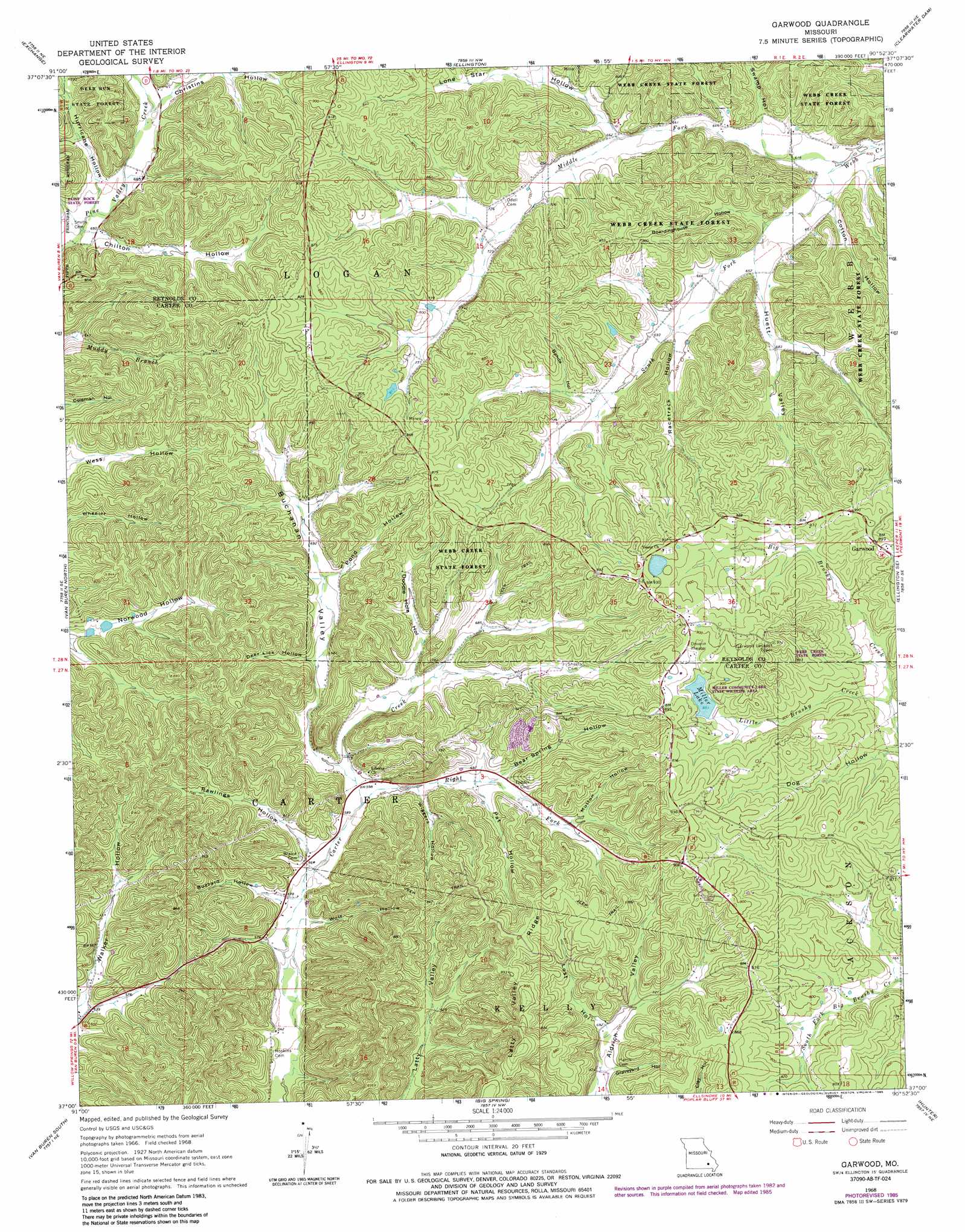
USGS Topo Quad 37090a8 - 1:24,000 scale
| Topo Map Name: | Garwood |
| USGS Topo Quad ID: | 37090a8 |
| Print Size: | ca. 21 1/4" wide x 27" high |
| Southeast Coordinates: | 37° N latitude / 90.875° W longitude |
| Map Center Coordinates: | 37.0625° N latitude / 90.9375° W longitude |
| U.S. State: | MO |
| Filename: | o37090a8.jpg |
| Download Map JPG Image: | Garwood topo map 1:24,000 scale |
| Map Type: | Topographic |
| Topo Series: | 7.5´ |
| Map Scale: | 1:24,000 |
| Source of Map Images: | United States Geological Survey (USGS) |
| Alternate Map Versions: |
Garwood MO 1968, updated 1969 Download PDF Buy paper map Garwood MO 1968, updated 1985 Download PDF Buy paper map Garwood MO 2011 Download PDF Buy paper map Garwood MO 2015 Download PDF Buy paper map |
1:24,000 Topo Quads surrounding Garwood
Midridge |
Corridon Se |
Redford |
Lesterville Se |
Des Arc |
Powder Mill Ferry |
Exchange |
Ellington |
Clearwater Dam |
Piedmont |
Stegall Mountain |
Van Buren North |
Garwood |
Ellington Se |
Mill Spring |
Fremont |
Van Buren South |
Big Spring |
Hunter |
Ellsinore |
Wilderness |
Handy |
Grandin Sw |
Grandin |
Hogan Hollow |
> Back to 37090a1 at 1:100,000 scale
> Back to 37090a1 at 1:250,000 scale
> Back to U.S. Topo Maps home
Garwood topo map: Gazetteer
Garwood: Dams
Hill and Dale East Dam elevation 191m 626′Hill and Dale West Dam elevation 189m 620′
Merrill Lake Dam elevation 259m 849′
Number 50 Dam elevation 279m 915′
Garwood: Forests
Webb Creek State Forest elevation 218m 715′Garwood: Parks
Miller Community Lake State Wildlife Area elevation 259m 849′Garwood: Populated Places
Garwood elevation 275m 902′Keeney Corner elevation 281m 921′
Garwood: Reservoirs
Miller Lake elevation 259m 849′Number 50 Lake elevation 279m 915′
Garwood: Ridges
Latty Valley Ridge elevation 283m 928′Garwood: Streams
Little Brushy Creek elevation 225m 738′Middle Fork Webb Creek elevation 183m 600′
Right Fork Carter Creek elevation 177m 580′
South Fork Webb Creek elevation 183m 600′
Garwood: Valleys
Bahda Hollow elevation 224m 734′Bear Spring Hollow elevation 196m 643′
Boardinghouse Hollow elevation 192m 629′
Buchanan Valley elevation 180m 590′
Buzzard Hollow elevation 173m 567′
Chilton Hollow elevation 197m 646′
Cotton Hollow elevation 191m 626′
Deer Lick Hollow elevation 196m 643′
Doodle Hole Hollow elevation 197m 646′
Graveyard Hollow elevation 208m 682′
Huett Valley elevation 198m 649′
Hurricane Hollow elevation 201m 659′
Lone Star Hollow elevation 201m 659′
Lost Hollow elevation 211m 692′
Mutton Hollow elevation 213m 698′
Pat Hollow elevation 192m 629′
Pine Valley elevation 198m 649′
Pond Hollow elevation 209m 685′
Racetrack Hollow elevation 207m 679′
Rawlings Hollow elevation 178m 583′
Swamp Hollow elevation 195m 639′
Wiggers Hollow elevation 186m 610′
Wolf Hollow elevation 169m 554′
Garwood digital topo map on disk
Buy this Garwood topo map showing relief, roads, GPS coordinates and other geographical features, as a high-resolution digital map file on DVD: