Patterson Topo Map Missouri
To zoom in, hover over the map of Patterson
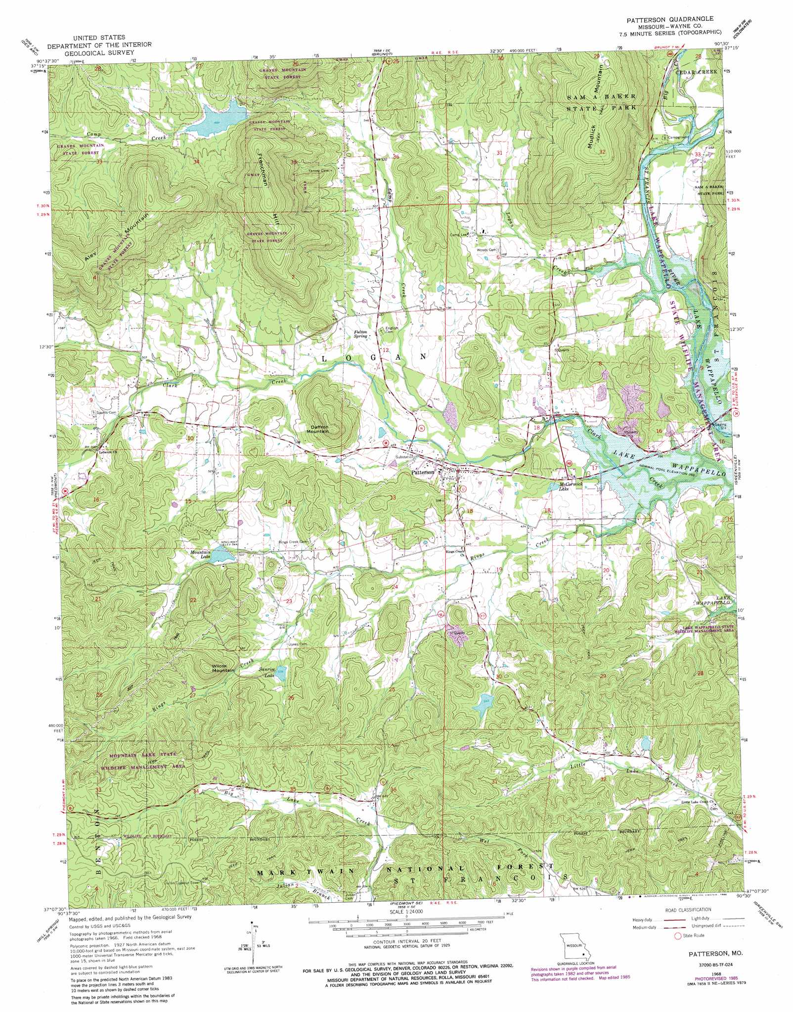
USGS Topo Quad 37090b5 - 1:24,000 scale
| Topo Map Name: | Patterson |
| USGS Topo Quad ID: | 37090b5 |
| Print Size: | ca. 21 1/4" wide x 27" high |
| Southeast Coordinates: | 37.125° N latitude / 90.5° W longitude |
| Map Center Coordinates: | 37.1875° N latitude / 90.5625° W longitude |
| U.S. State: | MO |
| Filename: | o37090b5.jpg |
| Download Map JPG Image: | Patterson topo map 1:24,000 scale |
| Map Type: | Topographic |
| Topo Series: | 7.5´ |
| Map Scale: | 1:24,000 |
| Source of Map Images: | United States Geological Survey (USGS) |
| Alternate Map Versions: |
Patterson MO 1968, updated 1969 Download PDF Buy paper map Patterson MO 1968, updated 1981 Download PDF Buy paper map Patterson MO 1968, updated 1985 Download PDF Buy paper map Patterson MO 2011 Download PDF Buy paper map Patterson MO 2015 Download PDF Buy paper map |
| FStopo: | US Forest Service topo Patterson is available: Download FStopo PDF Download FStopo TIF |
1:24,000 Topo Quads surrounding Patterson
Lesterville |
Glover |
Des Arc Ne |
Rock Pile Mountain |
Cherokee Pass |
Lesterville Se |
Des Arc |
Brunot |
Coldwater |
Cascade |
Clearwater Dam |
Piedmont |
Patterson |
Greenville |
Lowndes |
Ellington Se |
Mill Spring |
Piedmont Se |
Greenville Sw |
Shook |
Hunter |
Ellsinore |
Williamsville |
Hendrickson |
Wappapello |
> Back to 37090a1 at 1:100,000 scale
> Back to 37090a1 at 1:250,000 scale
> Back to U.S. Topo Maps home
Patterson topo map: Gazetteer
Patterson: Bridges
Black Bridge elevation 143m 469′Patterson: Dams
A O Shearrer Lake Dam elevation 159m 521′Collins Lake Section 31 Dam elevation 197m 646′
Frontier Lake Dam elevation 202m 662′
Little Hawaiis Lake Dam elevation 127m 416′
Maddox Lake Dam elevation 165m 541′
Mountain Lake Dam elevation 165m 541′
Sunrise Lake Dam elevation 169m 554′
Patterson: Lakes
McCormick Lake elevation 131m 429′Patterson: Populated Places
Damon elevation 210m 688′Patterson elevation 132m 433′
Rings elevation 149m 488′
Patterson: Reservoirs
A O Shearrer Lake elevation 159m 521′Collins Lake elevation 197m 646′
Frontier Lake elevation 202m 662′
Little Hawaiis Lake elevation 127m 416′
Maddox Lake elevation 165m 541′
Mountain Lake elevation 165m 541′
Sunrise Lake elevation 169m 554′
Patterson: Springs
Fulton Spring elevation 142m 465′Patterson: Streams
Big Creek elevation 119m 390′Camp Creek elevation 125m 410′
Logan Creek elevation 119m 390′
Peachtree Fork elevation 157m 515′
Rings Creek elevation 116m 380′
Patterson: Summits
Aley Mountain elevation 361m 1184′Daffron Mountain elevation 259m 849′
Frenchman Hill elevation 383m 1256′
Rings Creek Mountain elevation 147m 482′
Wilcox Mountain elevation 256m 839′
Patterson digital topo map on disk
Buy this Patterson topo map showing relief, roads, GPS coordinates and other geographical features, as a high-resolution digital map file on DVD: