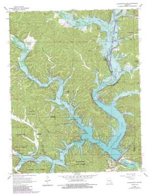
Clearwater Dam Topo Map Missouri
To zoom in, hover over the map of Clearwater Dam
USGS Topo Quad 37090b7 - 1:24,000 scale
| Topo Map Name: | Clearwater Dam |
| USGS Topo Quad ID: | 37090b7 |
| Print Size: | ca. 21 1/4" wide x 27" high |
| Southeast Coordinates: | 37.125° N latitude / 90.75° W longitude |
| Map Center Coordinates: | 37.1875° N latitude / 90.8125° W longitude |
| U.S. State: | MO |
| Filename: | o37090b7.jpg |
| Download Map JPG Image: | Clearwater Dam topo map 1:24,000 scale |
| Map Type: | Topographic |
| Topo Series: | 7.5´ |
| Map Scale: | 1:24,000 |
| Source of Map Images: | United States Geological Survey (USGS) |
| Alternate Map Versions: |
Clearwater Dam MO 1968, updated 1969 Download PDF Buy paper map Clearwater Dam MO 1968, updated 1985 Download PDF Buy paper map Clearwater Dam MO 1968, updated 1985 Download PDF Buy paper map Clearwater Dam MO 2011 Download PDF Buy paper map Clearwater Dam MO 2015 Download PDF Buy paper map |
1:24,000 Topo Quads surrounding Clearwater Dam
> Back to 37090a1 at 1:100,000 scale
> Back to 37090a1 at 1:250,000 scale
> Back to U.S. Topo Maps home
Clearwater Dam topo map: Gazetteer
Clearwater Dam: Cliffs
Brown Bluff elevation 170m 557′Charlton Bluff elevation 162m 531′
Finley Bluff elevation 182m 597′
Clearwater Dam: Dams
Clearwater Dam elevation 151m 495′Clearwater Dam: Forests
Bozarth State Forest elevation 234m 767′Graves Mountain State Forest elevation 183m 600′
Clearwater Dam: Parks
Bluff View Public Use Area elevation 163m 534′Clearwater Lake State Wildlife Management Area elevation 180m 590′
Piedmont Park Public Use Area elevation 178m 583′
River Road Public Use Area elevation 142m 465′
Thurman Point Public Use Area elevation 174m 570′
Webb Creek Public Use Area elevation 174m 570′
Clearwater Dam: Populated Places
Helvey (historical) elevation 181m 593′Riverside (historical) elevation 163m 534′
Webb (historical) elevation 181m 593′
Clearwater Dam: Reservoirs
Clearwater Lake elevation 174m 570′Clearwater Dam: Springs
Carter Spring elevation 164m 538′Lucy Spring elevation 160m 524′
Mann Spring elevation 160m 524′
Pleasant Spring elevation 162m 531′
Clearwater Dam: Streams
Doe Run Creek elevation 164m 538′Finley Branch elevation 151m 495′
Goose Creek elevation 151m 495′
Logan Creek elevation 151m 495′
North Fork Webb Creek elevation 167m 547′
Potter Branch elevation 160m 524′
Sinking Creek elevation 153m 501′
Webb Creek elevation 151m 495′
Clearwater Dam: Summits
Red Hill elevation 225m 738′Round Mountain elevation 291m 954′
Shy Mountain elevation 266m 872′
Clearwater Dam: Valleys
Brawley Hollow elevation 162m 531′Carter Hollow elevation 157m 515′
Cave Spring Hollow elevation 156m 511′
Dill Hollow elevation 160m 524′
Happy Hollow elevation 162m 531′
Mail Route Hollow elevation 170m 557′
McMillan Hollow elevation 160m 524′
Null Hollow elevation 160m 524′
Pinedale Valley elevation 169m 554′
Polecat Hollow elevation 160m 524′
Scaggs Hollow elevation 160m 524′
Seematter Hollow elevation 160m 524′
Tanbark Hollow elevation 169m 554′
Webb Valley elevation 154m 505′
Clearwater Dam digital topo map on disk
Buy this Clearwater Dam topo map showing relief, roads, GPS coordinates and other geographical features, as a high-resolution digital map file on DVD:


