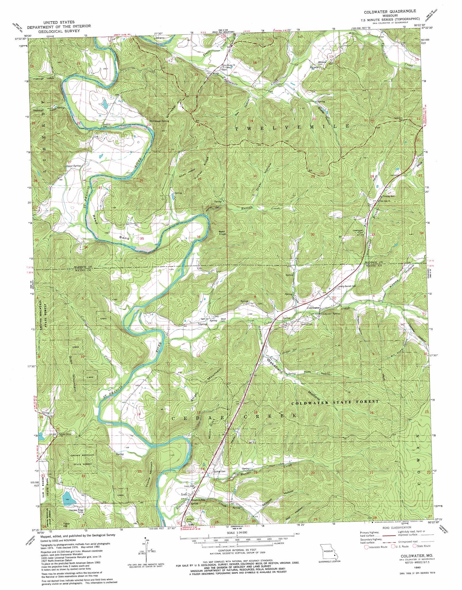
Coldwater Topo Map Missouri
To zoom in, hover over the map of Coldwater
USGS Topo Quad 37090c4 - 1:24,000 scale
| Topo Map Name: | Coldwater |
| USGS Topo Quad ID: | 37090c4 |
| Print Size: | ca. 21 1/4" wide x 27" high |
| Southeast Coordinates: | 37.25° N latitude / 90.375° W longitude |
| Map Center Coordinates: | 37.3125° N latitude / 90.4375° W longitude |
| U.S. State: | MO |
| Filename: | o37090c4.jpg |
| Download Map JPG Image: | Coldwater topo map 1:24,000 scale |
| Map Type: | Topographic |
| Topo Series: | 7.5´ |
| Map Scale: | 1:24,000 |
| Source of Map Images: | United States Geological Survey (USGS) |
| Alternate Map Versions: |
Coldwater MO 1980, updated 1980 Download PDF Buy paper map Coldwater MO 2011 Download PDF Buy paper map Coldwater MO 2015 Download PDF Buy paper map |
1:24,000 Topo Quads surrounding Coldwater
Ironton |
Lake Killarney |
Rhodes Mountain |
Fredericktown |
Higdon |
Glover |
Des Arc Ne |
Rock Pile Mountain |
Cherokee Pass |
Marquand |
Des Arc |
Brunot |
Coldwater |
Cascade |
Allbright |
Piedmont |
Patterson |
Greenville |
Lowndes |
Gipsy |
Mill Spring |
Piedmont Se |
Greenville Sw |
Shook |
Mcgee |
> Back to 37090a1 at 1:100,000 scale
> Back to 37090a1 at 1:250,000 scale
> Back to U.S. Topo Maps home
Coldwater topo map: Gazetteer
Coldwater: Bends
Reed Bend elevation 134m 439′Coldwater: Dams
Otahki Lake Dam elevation 150m 492′Coldwater: Populated Places
Coldwater elevation 149m 488′Head Ford (historical) elevation 129m 423′
Lodi elevation 130m 426′
Saco elevation 154m 505′
Shelton Ford elevation 140m 459′
Varsh Ford elevation 147m 482′
Coldwater: Ranges
Cold Water Hills elevation 219m 718′Coldwater: Reservoirs
Otahki Lake elevation 150m 492′Coldwater: Ridges
Turkey Ridge elevation 245m 803′Coldwater: Springs
Coldwater Spring elevation 152m 498′Spout Spring elevation 148m 485′
Stillhouse Spring elevation 145m 475′
Coldwater: Streams
Bennett Creek elevation 122m 400′Bennett Creek elevation 147m 482′
Cedar Creek elevation 128m 419′
Collier Creek elevation 127m 416′
Coon Creek elevation 146m 479′
Greenwood Branch elevation 152m 498′
Hunter Creek elevation 130m 426′
Huzzah Creek elevation 133m 436′
Trace Creek elevation 146m 479′
Twelvemile Creek elevation 146m 479′
Wilmore Creek elevation 143m 469′
Coldwater: Summits
Bald Knob elevation 207m 679′Gray Mountain elevation 220m 721′
Mount Glory elevation 220m 721′
Strahl Mountain elevation 233m 764′
Tater Hill elevation 237m 777′
Victoria Mountain elevation 202m 662′
Whitaker Hill elevation 264m 866′
Wilkinson Mountain elevation 224m 734′
Coldwater: Valleys
Adams Hollow elevation 160m 524′Bill Goad Hollow elevation 174m 570′
Dorsey Hollow elevation 165m 541′
Dryer Hollow elevation 183m 600′
Firebaugh Hollow elevation 141m 462′
Gregory Hollow elevation 153m 501′
Huzzah Canyon elevation 133m 436′
Jordon Hollow elevation 152m 498′
Mitchell Hollow elevation 143m 469′
Philis Hollow elevation 160m 524′
Ray Hollow elevation 152m 498′
Seabaugh Hollow elevation 140m 459′
Shafer Hollow elevation 157m 515′
Squaw Hollow elevation 157m 515′
Wakefield Hollow elevation 151m 495′
Coldwater digital topo map on disk
Buy this Coldwater topo map showing relief, roads, GPS coordinates and other geographical features, as a high-resolution digital map file on DVD: