Marquand Topo Map Missouri
To zoom in, hover over the map of Marquand
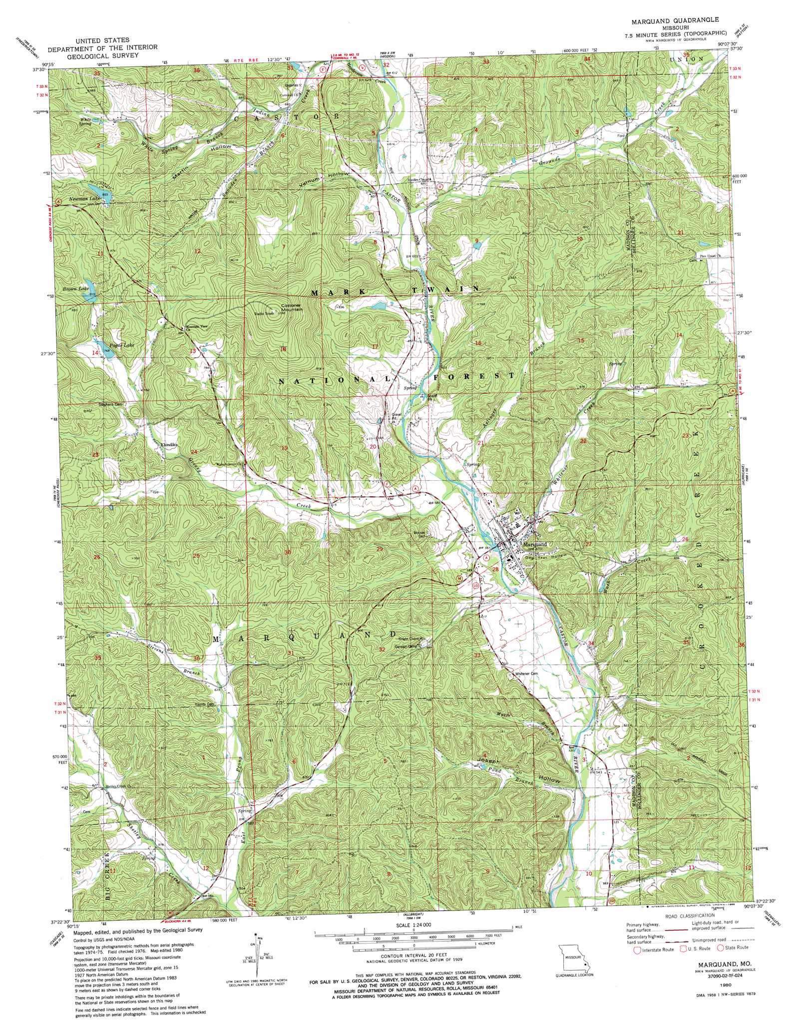
USGS Topo Quad 37090d2 - 1:24,000 scale
| Topo Map Name: | Marquand |
| USGS Topo Quad ID: | 37090d2 |
| Print Size: | ca. 21 1/4" wide x 27" high |
| Southeast Coordinates: | 37.375° N latitude / 90.125° W longitude |
| Map Center Coordinates: | 37.4375° N latitude / 90.1875° W longitude |
| U.S. State: | MO |
| Filename: | o37090d2.jpg |
| Download Map JPG Image: | Marquand topo map 1:24,000 scale |
| Map Type: | Topographic |
| Topo Series: | 7.5´ |
| Map Scale: | 1:24,000 |
| Source of Map Images: | United States Geological Survey (USGS) |
| Alternate Map Versions: |
Marquand MO 1980, updated 1980 Download PDF Buy paper map Marquand MO 1980, updated 1986 Download PDF Buy paper map Marquand MO 2000, updated 2003 Download PDF Buy paper map Marquand MO 2011 Download PDF Buy paper map Marquand MO 2015 Download PDF Buy paper map |
| FStopo: | US Forest Service topo Marquand is available: Download FStopo PDF Download FStopo TIF |
1:24,000 Topo Quads surrounding Marquand
Wachita Mountain |
Knob Lick |
Womack |
Parker Lake |
Perryville West |
Rhodes Mountain |
Fredericktown |
Higdon |
Patton |
Sedgewickville |
Rock Pile Mountain |
Cherokee Pass |
Marquand |
Hurricane |
Scopus |
Coldwater |
Cascade |
Allbright |
Glenallen |
Marble Hill |
Greenville |
Lowndes |
Gipsy |
Zalma |
Dongola |
> Back to 37090a1 at 1:100,000 scale
> Back to 37090a1 at 1:250,000 scale
> Back to U.S. Topo Maps home
Marquand topo map: Gazetteer
Marquand: Dams
Neville Dam elevation 200m 656′Newman Lake Dam elevation 246m 807′
Pogue Lake Dam elevation 265m 869′
Smittys Catfish Pond Dam elevation 270m 885′
Marquand: Mines
Cozean Mine (historical) elevation 228m 748′Starkey Mine (historical) elevation 193m 633′
Marquand: Populated Places
Klendike elevation 200m 656′Marquand elevation 175m 574′
Marquand: Reservoirs
Brown Lake elevation 248m 813′Leaky Lake elevation 200m 656′
Newman Lake elevation 280m 918′
Pogue Lake elevation 232m 761′
Pogue Pond elevation 265m 869′
Marquand: Springs
White Spring elevation 248m 813′Marquand: Streams
Ashinger Branch elevation 170m 557′East Prong Shetley Creek elevation 166m 544′
Greasy Creek elevation 168m 551′
Grounds Creek elevation 178m 583′
Henderson Creek elevation 184m 603′
Indian Creek elevation 187m 613′
Myers Branch elevation 161m 528′
Pond Branch elevation 159m 521′
Snowden Branch elevation 190m 623′
Stevens Branch elevation 195m 639′
Wash Creek elevation 165m 541′
White Spring Branch elevation 210m 688′
Whitener Creek elevation 166m 544′
Whiteners Creek elevation 161m 528′
Marquand: Summits
Cottoner Mountain elevation 376m 1233′Marquand: Valleys
Dog Trot Hollow elevation 176m 577′Joseph Hollow elevation 158m 518′
Martin Hollow elevation 208m 682′
Vernum Hollow elevation 180m 590′
Marquand digital topo map on disk
Buy this Marquand topo map showing relief, roads, GPS coordinates and other geographical features, as a high-resolution digital map file on DVD: