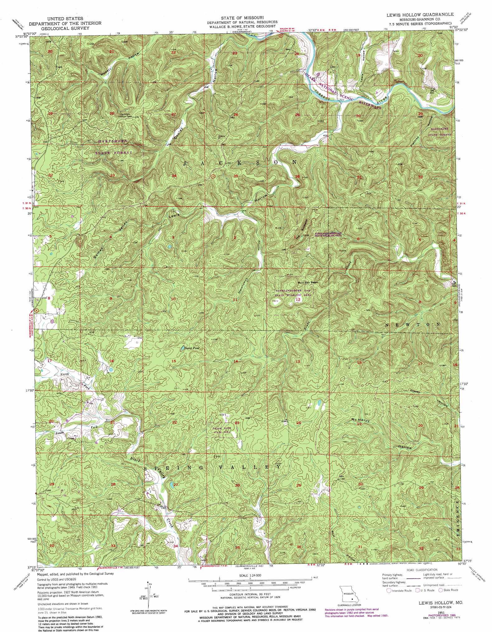
Lewis Hollow Topo Map Missouri
To zoom in, hover over the map of Lewis Hollow
USGS Topo Quad 37091c5 - 1:24,000 scale
| Topo Map Name: | Lewis Hollow |
| USGS Topo Quad ID: | 37091c5 |
| Print Size: | ca. 21 1/4" wide x 27" high |
| Southeast Coordinates: | 37.25° N latitude / 91.5° W longitude |
| Map Center Coordinates: | 37.3125° N latitude / 91.5625° W longitude |
| U.S. State: | MO |
| Filename: | o37091c5.jpg |
| Download Map JPG Image: | Lewis Hollow topo map 1:24,000 scale |
| Map Type: | Topographic |
| Topo Series: | 7.5´ |
| Map Scale: | 1:24,000 |
| Source of Map Images: | United States Geological Survey (USGS) |
| Alternate Map Versions: |
Lewis Hollow MO 1951, updated 1952 Download PDF Buy paper map Lewis Hollow MO 1951, updated 1965 Download PDF Buy paper map Lewis Hollow MO 1951, updated 1971 Download PDF Buy paper map Lewis Hollow MO 1951, updated 1985 Download PDF Buy paper map Lewis Hollow MO 1951, updated 1985 Download PDF Buy paper map Lewis Hollow MO 2011 Download PDF Buy paper map Lewis Hollow MO 2015 Download PDF Buy paper map |
1:24,000 Topo Quads surrounding Lewis Hollow
Maples |
Rhyse |
Darien |
Doss |
Stone Hill |
Licking |
Montauk |
Cedar Grove |
Gladden |
Loggers Lake |
Raymondville |
Hartshorn |
Lewis Hollow |
Round Spring |
The Sinks |
Eunice |
Summersville |
Summersville Ne |
Alley Spring |
Eminence |
Clear Springs |
Pine Crest |
Jam Up Cave |
Bartlett |
Winona |
> Back to 37091a1 at 1:100,000 scale
> Back to 37090a1 at 1:250,000 scale
> Back to U.S. Topo Maps home
Lewis Hollow topo map: Gazetteer
Lewis Hollow: Basins
Burr Oak Basin elevation 309m 1013′The Sunkland elevation 294m 964′
Lewis Hollow: Forests
Hartshorn State Forest elevation 279m 915′Lewis Hollow: Lakes
Skunk Pond elevation 366m 1200′Lewis Hollow: Parks
Skunk Pond State Wildlife Management Area elevation 372m 1220′Sunklands-Burr Oak State Wildlife Area elevation 330m 1082′
Lewis Hollow: Streams
North Fork Black Valley Creek elevation 338m 1108′South Fork Black Valley Creek elevation 338m 1108′
Lewis Hollow: Trails
Wagon Trace elevation 233m 764′Lewis Hollow: Valleys
Dooley Hollow elevation 234m 767′Fishtrap Hollow elevation 233m 764′
Hieronymus Hollow elevation 280m 918′
Lewis Hollow elevation 233m 764′
Lewis Hollow elevation 234m 767′
Sumac Valley elevation 302m 990′
Lewis Hollow digital topo map on disk
Buy this Lewis Hollow topo map showing relief, roads, GPS coordinates and other geographical features, as a high-resolution digital map file on DVD: