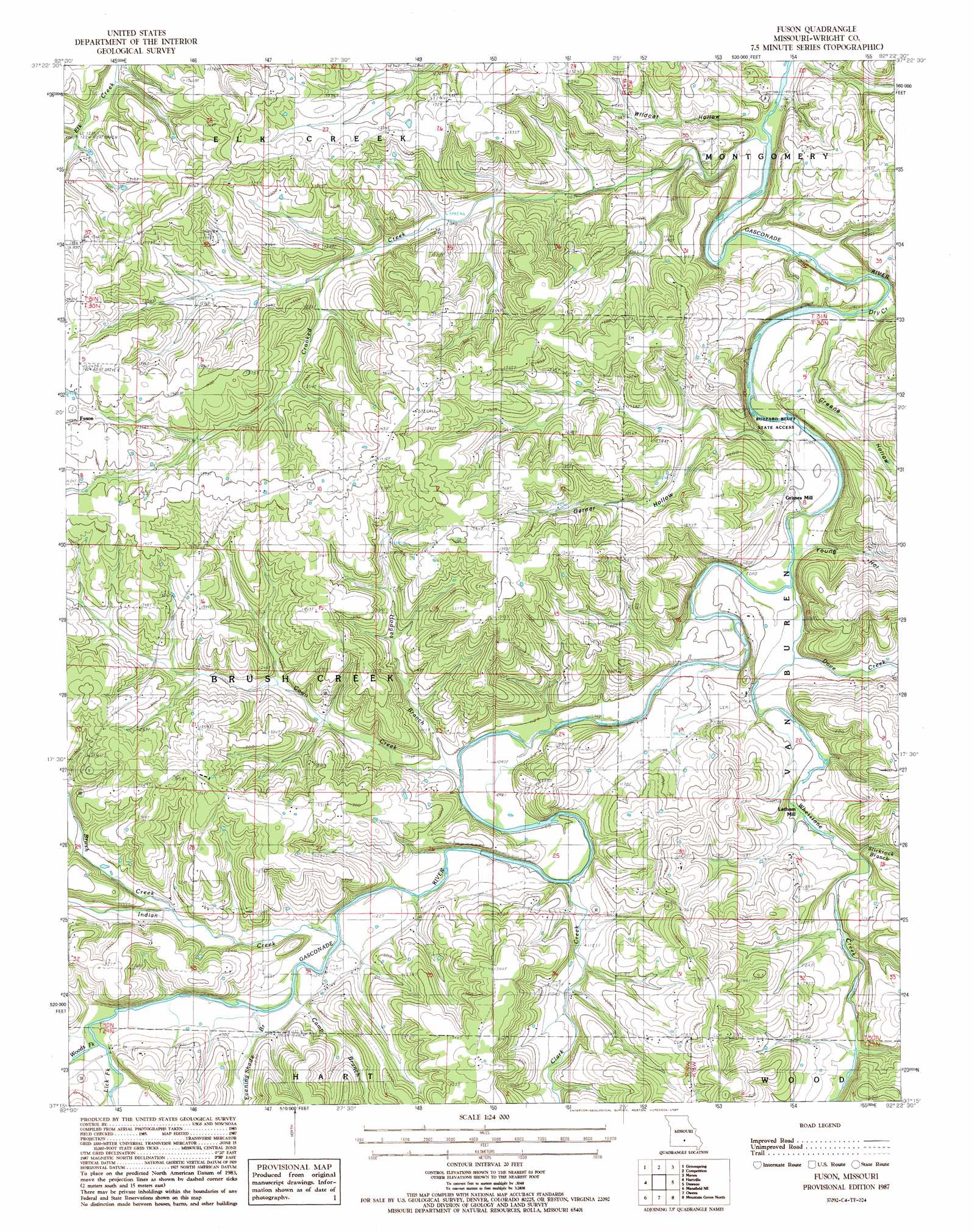
Fuson Topo Map Missouri
To zoom in, hover over the map of Fuson
USGS Topo Quad 37092c4 - 1:24,000 scale
| Topo Map Name: | Fuson |
| USGS Topo Quad ID: | 37092c4 |
| Print Size: | ca. 21 1/4" wide x 27" high |
| Southeast Coordinates: | 37.25° N latitude / 92.375° W longitude |
| Map Center Coordinates: | 37.3125° N latitude / 92.4375° W longitude |
| U.S. State: | MO |
| Filename: | o37092c4.jpg |
| Download Map JPG Image: | Fuson topo map 1:24,000 scale |
| Map Type: | Topographic |
| Topo Series: | 7.5´ |
| Map Scale: | 1:24,000 |
| Source of Map Images: | United States Geological Survey (USGS) |
| Alternate Map Versions: |
Fuson MO 1987, updated 1987 Download PDF Buy paper map Fuson MO 2011 Download PDF Buy paper map Fuson MO 2015 Download PDF Buy paper map |
1:24,000 Topo Quads surrounding Fuson
Brush Creek |
Russ |
Drew |
Winnipeg |
Roby |
Rader |
Grovespring |
Competition |
Manes |
Roubidoux |
Duncan |
Hartville |
Fuson |
Dawson |
Huggins |
Mansfield Nw |
Mansfield Ne |
Owens |
Mountain Grove North |
Cabool Nw |
Cedar Gap |
Mansfield |
Norwood |
Mountain Grove South |
Cabool Sw |
> Back to 37092a1 at 1:100,000 scale
> Back to 37092a1 at 1:250,000 scale
> Back to U.S. Topo Maps home
Fuson topo map: Gazetteer
Fuson: Areas
Needles Eye elevation 340m 1115′Fuson: Populated Places
Fuson elevation 427m 1400′Grimes Mill elevation 351m 1151′
Latham Mill elevation 337m 1105′
Talmage elevation 386m 1266′
Fuson: Post Offices
Talmage Post Office elevation 386m 1266′Fuson: Streams
Brush Creek elevation 352m 1154′Camp Branch elevation 340m 1115′
Clark Creek elevation 334m 1095′
Coon Creek elevation 329m 1079′
Crooked Creek elevation 322m 1056′
Dove Creek elevation 327m 1072′
Dry Creek elevation 325m 1066′
Evening Shade Branch elevation 342m 1122′
Hodges Branch elevation 330m 1082′
Indian Creek elevation 338m 1108′
Lick Fork Gasconade River elevation 346m 1135′
Slickrock Branch elevation 334m 1095′
Whetstone Creek elevation 325m 1066′
Woods Fork Gasconade River elevation 346m 1135′
Fuson: Valleys
Garner Hollow elevation 330m 1082′Greene Hollow elevation 327m 1072′
Wildcat Hollow elevation 326m 1069′
Young Hollow elevation 329m 1079′
Fuson digital topo map on disk
Buy this Fuson topo map showing relief, roads, GPS coordinates and other geographical features, as a high-resolution digital map file on DVD: