Slabtown Spring Topo Map Missouri
To zoom in, hover over the map of Slabtown Spring
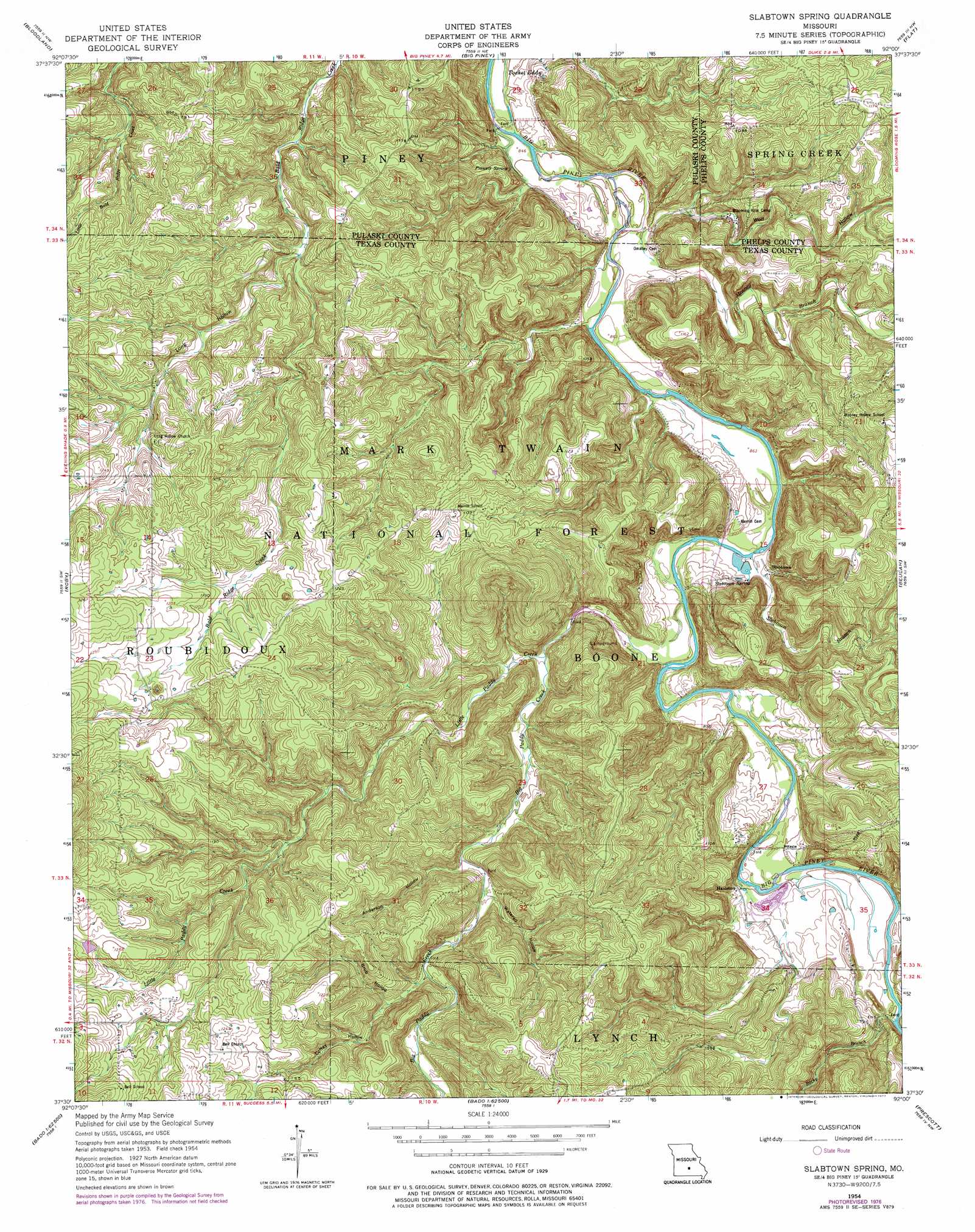
USGS Topo Quad 37092e1 - 1:24,000 scale
| Topo Map Name: | Slabtown Spring |
| USGS Topo Quad ID: | 37092e1 |
| Print Size: | ca. 21 1/4" wide x 27" high |
| Southeast Coordinates: | 37.5° N latitude / 92° W longitude |
| Map Center Coordinates: | 37.5625° N latitude / 92.0625° W longitude |
| U.S. State: | MO |
| Filename: | o37092e1.jpg |
| Download Map JPG Image: | Slabtown Spring topo map 1:24,000 scale |
| Map Type: | Topographic |
| Topo Series: | 7.5´ |
| Map Scale: | 1:24,000 |
| Source of Map Images: | United States Geological Survey (USGS) |
| Alternate Map Versions: |
Slabtown Spring MO 1954, updated 1959 Download PDF Buy paper map Slabtown Spring MO 1954, updated 1974 Download PDF Buy paper map Slabtown Spring MO 1954, updated 1977 Download PDF Buy paper map Slabtown Spring MO 2004, updated 2006 Download PDF Buy paper map Slabtown Spring MO 2012 Download PDF Buy paper map Slabtown Spring MO 2015 Download PDF Buy paper map |
| FStopo: | US Forest Service topo Slabtown Spring is available: Download FStopo PDF Download FStopo TIF |
1:24,000 Topo Quads surrounding Slabtown Spring
Ozark Springs |
Waynesville |
Devils Elbow |
Kaintuck Hollow |
Yancy Mills |
Brownfield |
Bloodland |
Big Piney |
Flat |
Edgar Springs |
Winnipeg |
Roby |
Slabtown Spring |
Beulah |
Maples |
Manes |
Roubidoux |
Success |
Prescott |
Licking |
Dawson |
Huggins |
Bucyrus |
Houston |
Raymondville |
> Back to 37092e1 at 1:100,000 scale
> Back to 37092a1 at 1:250,000 scale
> Back to U.S. Topo Maps home
Slabtown Spring topo map: Gazetteer
Slabtown Spring: Basins
Pocket Eddy elevation 280m 918′Slabtown Spring: Dams
Roby Number 1 Dam elevation 372m 1220′Slabtown Dam elevation 267m 875′
Slabtown Spring: Populated Places
Edanville elevation 267m 875′Hazleton elevation 276m 905′
Ladd elevation 340m 1115′
Slabtown elevation 271m 889′
Slabtown Spring: Reservoirs
Roby Lake elevation 372m 1220′Slabtown Lake elevation 267m 875′
Slabtown Spring: Springs
Prewett Spring elevation 287m 941′Slabtown Spring elevation 268m 879′
Slabtown Spring: Streams
Big Paddy Creek elevation 265m 869′Little Paddy Creek elevation 277m 908′
Mooney Branch elevation 259m 849′
Rocky Branch elevation 272m 892′
Slabtown Branch elevation 263m 862′
Slabtown Spring: Summits
Cabbage Head elevation 332m 1089′Slabtown Spring: Trails
Big Piney Trail elevation 320m 1049′Paddy Creek Trail elevation 296m 971′
Slabtown Bluff Trail elevation 322m 1056′
Slabtown Spring: Valleys
Anderson Hollow elevation 297m 974′Coffey Hollow elevation 305m 1000′
Grub Hollow elevation 314m 1030′
Long Hollow elevation 313m 1026′
Watered Hollow elevation 299m 980′
Wolf Hollow elevation 259m 849′
Slabtown Spring digital topo map on disk
Buy this Slabtown Spring topo map showing relief, roads, GPS coordinates and other geographical features, as a high-resolution digital map file on DVD: