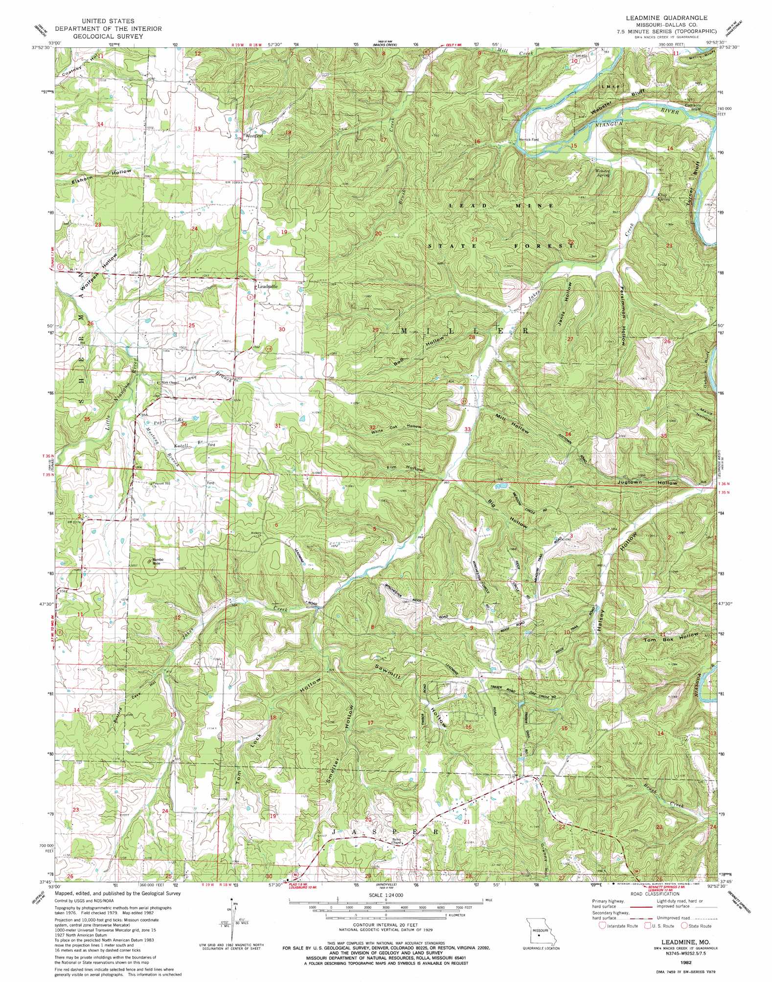
Leadmine Topo Map Missouri
To zoom in, hover over the map of Leadmine
USGS Topo Quad 37092g8 - 1:24,000 scale
| Topo Map Name: | Leadmine |
| USGS Topo Quad ID: | 37092g8 |
| Print Size: | ca. 21 1/4" wide x 27" high |
| Southeast Coordinates: | 37.75° N latitude / 92.875° W longitude |
| Map Center Coordinates: | 37.8125° N latitude / 92.9375° W longitude |
| U.S. State: | MO |
| Filename: | o37092g8.jpg |
| Download Map JPG Image: | Leadmine topo map 1:24,000 scale |
| Map Type: | Topographic |
| Topo Series: | 7.5´ |
| Map Scale: | 1:24,000 |
| Source of Map Images: | United States Geological Survey (USGS) |
| Alternate Map Versions: |
Leadmine MO 1982, updated 1983 Download PDF Buy paper map Leadmine MO 2012 Download PDF Buy paper map Leadmine MO 2015 Download PDF Buy paper map |
1:24,000 Topo Quads surrounding Leadmine
Cross Timbers |
Climax Springs |
Barnumton |
Green Bay Terrace |
Camdenton |
Preston |
Branch |
Macks Creek |
Hahatonka |
Decaturville |
Urbana |
Tunas |
Leadmine |
Eldridge West |
Eldridge East |
Buffalo Nw |
Buffalo |
Windyville |
Bennett Springs |
Lebanon |
Half Way |
Charity |
Long Lake |
Phillipsburg |
Brush Creek |
> Back to 37092e1 at 1:100,000 scale
> Back to 37092a1 at 1:250,000 scale
> Back to U.S. Topo Maps home
Leadmine topo map: Gazetteer
Leadmine: Cliffs
Osborn Bluff elevation 258m 846′Turner Bluff elevation 227m 744′
Webster Bluff elevation 276m 905′
Leadmine: Forests
Lead Mine State Forest elevation 319m 1046′Leadmine: Mines
Rambo Mine elevation 335m 1099′Leadmine: Populated Places
Berry Ford (historical) elevation 227m 744′Herrick Ford elevation 225m 738′
Leadmine elevation 333m 1092′
Westfield elevation 328m 1076′
Leadmine: Springs
King Spring elevation 242m 793′Webster Spring elevation 254m 833′
Leadmine: Streams
Brush Creek elevation 247m 810′Jakes Creek elevation 226m 741′
Katell Branch elevation 298m 977′
Lane Branch elevation 288m 944′
Mustang Branch elevation 293m 961′
Pearl Branch elevation 293m 961′
Leadmine: Valleys
Big Hollow elevation 262m 859′Bob Hollow elevation 251m 823′
Buzzard Cave Hollow elevation 298m 977′
Elm Hollow elevation 262m 859′
Jantz Hollow elevation 242m 793′
Jugtown Hollow elevation 252m 826′
Mill Hollow elevation 254m 833′
Persimmon Hollow elevation 240m 787′
Sawmill Hollow elevation 280m 918′
Smelter Hollow elevation 282m 925′
Tom Lock Hollow elevation 282m 925′
Whiteoak Hollow elevation 260m 853′
Wolfpen Hollow elevation 289m 948′
Leadmine digital topo map on disk
Buy this Leadmine topo map showing relief, roads, GPS coordinates and other geographical features, as a high-resolution digital map file on DVD: