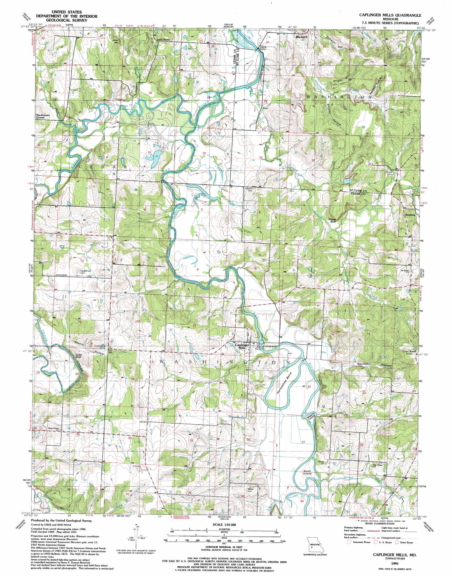
Caplinger Mills Topo Map Missouri
To zoom in, hover over the map of Caplinger Mills
USGS Topo Quad 37093g7 - 1:24,000 scale
| Topo Map Name: | Caplinger Mills |
| USGS Topo Quad ID: | 37093g7 |
| Print Size: | ca. 21 1/4" wide x 27" high |
| Southeast Coordinates: | 37.75° N latitude / 93.75° W longitude |
| Map Center Coordinates: | 37.8125° N latitude / 93.8125° W longitude |
| U.S. State: | MO |
| Filename: | o37093g7.jpg |
| Download Map JPG Image: | Caplinger Mills topo map 1:24,000 scale |
| Map Type: | Topographic |
| Topo Series: | 7.5´ |
| Map Scale: | 1:24,000 |
| Source of Map Images: | United States Geological Survey (USGS) |
| Alternate Map Versions: |
Caplinger Mills MO 1939, updated 1941 Download PDF Buy paper map Caplinger Mills MO 1939, updated 1954 Download PDF Buy paper map Caplinger Mills MO 1939, updated 1967 Download PDF Buy paper map Caplinger Mills MO 1941 Download PDF Buy paper map Caplinger Mills MO 1991, updated 1991 Download PDF Buy paper map Caplinger Mills MO 2011 Download PDF Buy paper map Caplinger Mills MO 2015 Download PDF Buy paper map |
1:24,000 Topo Quads surrounding Caplinger Mills
Rockville |
Taberville |
Monegaw Springs |
Osceola |
Iconium |
Eldorado Springs North |
Tiffin |
Roscoe |
Vista |
Weaubleau |
Eldorado Springs South |
Filley |
Caplinger Mills |
Arnica |
Humansville |
Montevallo |
Wagoner |
Stockton |
Bearcreek |
Fair Play |
Jerico Springs |
Cedarville |
Crisp |
Bona |
Aldrich |
> Back to 37093e1 at 1:100,000 scale
> Back to 37092a1 at 1:250,000 scale
> Back to U.S. Topo Maps home
Caplinger Mills topo map: Gazetteer
Caplinger Mills: Bends
Horseshoe Bend elevation 232m 761′Caplinger Mills: Cliffs
Cedar Bluff elevation 247m 810′Moore Bluff elevation 246m 807′
Caplinger Mills: Dams
Caplinger Mills Dam elevation 232m 761′Cowan Lake East Dam elevation 237m 777′
Cowan Lake West Dam elevation 240m 787′
Dorman Lake Dam elevation 241m 790′
Hickman Lake Dam elevation 255m 836′
Caplinger Mills: Guts
Younger Slough elevation 234m 767′Caplinger Mills: Islands
Keith Island elevation 235m 770′Masters Island elevation 232m 761′
Caplinger Mills: Populated Places
Blackjack elevation 232m 761′Caplinger Mills elevation 245m 803′
Fairview (historical) elevation 253m 830′
Graceland elevation 266m 872′
Hackleman Corner elevation 248m 813′
Ivy elevation 261m 856′
Rookins elevation 245m 803′
Caplinger Mills: Ranges
Coal Bank Hills elevation 314m 1030′Caplinger Mills: Reservoirs
Cowan Lake East elevation 237m 777′Cowan Lake West elevation 240m 787′
Dorman Lake elevation 241m 790′
Hackleman Corner Lake elevation 233m 764′
Hickman Lake elevation 255m 836′
Sac River Reservoir elevation 232m 761′
Caplinger Mills: Streams
Camp Creek elevation 229m 751′Cave Branch elevation 226m 741′
Cedar Creek elevation 225m 738′
Flood Branch elevation 238m 780′
Little Turkey Creek elevation 236m 774′
Silver Creek elevation 233m 764′
Stockton Branch elevation 233m 764′
Turkey Creek elevation 223m 731′
Caplinger Mills: Summits
Cave Hill elevation 261m 856′Caplinger Mills: Valleys
Bland Hollow elevation 231m 757′Church Hollow elevation 235m 770′
Panther Den Hollow elevation 253m 830′
Ritchson Hollow elevation 233m 764′
Wright Hollow elevation 242m 793′
Caplinger Mills digital topo map on disk
Buy this Caplinger Mills topo map showing relief, roads, GPS coordinates and other geographical features, as a high-resolution digital map file on DVD: